Semantic enhancement of 3D buildings with the cadastre
Most 3D city models are initially devoid of semantic information since they were generated from raw data such as LiDAR scans or imagery. However, this semantic may be necessary if we look for more than just a simple geometry in a virtual city model. We have designed a method to improve a 3D model defining city buildings using a polygonal 2D database as the cadastre map. There is indeed much accessible information defining an urban area related to databases of 2D polygons representing the concerned zones.
The building concept in a newly created 3D city model is often imprecise; however, this linkage with the cadastre will allow us to assign a 3D geometry for each building defined by a cadastral ID. We thus provide an output set of buildings. Each of these contains 3D modeling, semantic information defined in the cadastre, and any relations to external databases accessible via its cadastral ID.
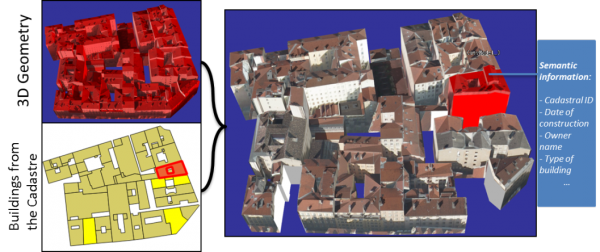
A single building from a 3D city model (top-left) and the cadastral buildings of the same area (bottom-left) are linked; a split 3D model according to the cadastre is generated by our method (right). A building is picked (highlighted in red), and some others are hidden (yellow polygons on the bottom-left). Each of these buildings has a set of semantic information collected thanks to the cadastre.