Measuring urban visibility
There is an increasing number of studies on the impact of urbanization projects on the surrounding territories. A visual impact study involves understanding the changes brought by such projects on the visibility of a city from any location, near or far from where a city is visible. The growing availability of open city data, like 3D models, is very promising to carry out such studies. However, there is a need for newer algorithms to compute the visibility of cities from multiple points of view. These algorithms must foster data interoperability by linking their results with other data and completing the study with information derived from various city models. We have developed a new method for studying visibility using a 3D model assembling several objects composing the city with the available user data in a generic manner. This method relies on a tiling process and an appropriate hierarchical strategy to apply the study over vast territories. The obtained results allow measuring the impact of an urbanization project by comparing the visibility study with and without this project or among its different versions.
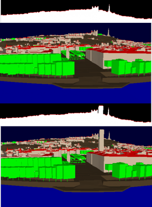

Two visibility analyses compare the skyline from a given point of view before and after the construction of an imaginary tower. We can compare, for example, the composition of this skyline: the tower reduces the proportion of vegetation on the skyline and increases that of the buildings.