What is UNIMAP?
Several providers of Location-Based Services (LBS) in the field of tourist information provide us with similar services (Google, Bing, Michelin, OpenStreetMap, Hotels.com, Booking.com, Tourist Information Centers, etc). The Points of Interest (POIs) can be different and inconsistent from one provider to another (the same POI can have different names, different locations, different properties, different representations, etc). In this context, the UNIMAP project aims at providing Location-Based Services in which data from various suppliers are integrated in order to ensure the completeness and the correction of the results for a given query.
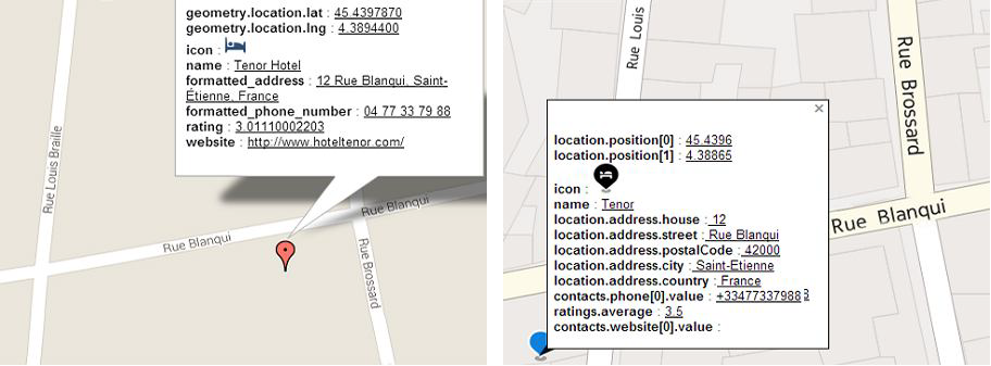
To illustrate the new cartographic integration issues, let us study the figure below which shows the same POI (Tenor Hotel, Saint-Etienne city, France) using two providers. The bold and underlined texts refer to schemata and data respectively. Schemata heterogeneity is distinguished at two levels: (i) attribute name heterogeneity such as location.position[0] and geometry.location.lat and (ii) structure heterogeneity such as location.address.house, location.address.street and formatted_address. In addition, values differ from one provider to another. In this example, the place named by the first provider is Tenor Hotel while the second provides Tenor only. Also, differences in geographic coordinates values (latitude/longitude) cause different positions for the POI, the first provider places the POI at the right side of Louis Braille street, in contrast with the second which places it on the other side of the street. And note that some values may be missing such as the contacts.website[0].value in the second provider. Finally, regarding map design, providers use different background maps, legends, colors and icons. Users who seek several providers to validate some spatial information, feel a sense of conflict because of those differences.
The above example shows that unifying LBS of multiprovider requires the integration of heterogeneous data structures, the reconciliation of different spatial data and to get accurate and meaningful representation of the unified data.
The PhD thesis associated to UNIMAP addresses this challenge in order to find solutions to integrate POIs and to represent them. While the whole project takes into account other issues such us cognitive aspects and semiology.
In order to proof the necessity of POIs integration, we invite you to visite our prototype that allows to select POIs from many providers and display them on the same map to be compared.
Prototype link: http://liris-unimap01.insa-lyon.fr/prototype_providers/places.html