2024
Conference papers
-
- titre
- Routes to a building or a room suited to the specific needs of users
- auteur
- Stéphanie Jean-Daubias, Thierry Excoffier, Otman Azziz
- resume
- OPALE is a multi-service mobile app for users of the Claude Bernard Lyon 1 University campuses, combining the discovery of practical, cultural and scientific resources with useful everyday functions. Points of interest are geolocated on a map of the campus and can be reached via an itinerary. But an itinerary to a building is not always enough to find your way around. The orientation problem often lies in the last few metres: between the entrance to the building and the room you are looking for. In this article we present OPALE, and the approach we have adopted to solve this problem of orienting users in a building. We will also show how we take into account the specific characteristics of users, particularly those with physical or cognitive disabilities.
- Accès au texte intégral et bibtex
-


2021
Conference papers
-
- titre
- Visualisation d'équipements de la maintenance à l'aide de données geospatiales
- auteur
- Clement Colin, John Samuel Samuel, Sylvie Servigne, Y Miloudi, Gilles Gesquière
- resume
- La gestion de maintenance assistée par l'ordinateur a pour objectif d'assister les agents d'administrations et d'entretiens dans leurs missions de maintiens d'équipements (bâtiment, réseau, climatisation, robinet ...). Ces équipements disposent de différentes représentations présentes dans des sources de données géospatiales. Elles peuvent permettre une meilleure compréhension d'un équipement en apportant de nouvelles informations. Dans cet article, nous proposons une solution pour mobiliser et visualiser différentes données géospatiales, (Ifc, CityGML, Obj ...) dans un même environnement de visualisation sur le web, à l'aide de flux standardisés (WFS,WMS) et de formats de géométrie standardisé (3DTiles).
- Accès au texte intégral et bibtex
-

-
- titre
- Benefit of coupling 1d-2d model over an urban area to assess runoff during a storm event
- auteur
- Nathalie Bertrand, Morgan Abily, Malo Lambert, Olivier Delestre
- resume
- Stormwater or rainwater networks are essential infrastructures in urban areas to reduce the runoff during storm events. In recent years, several storm events occurred in France especially in Mediterranean regions leading to severe urban floods, mainly due to the capacity of storm network to cope with runoff generated by extreme rainfall events. Therefore, flood risk analysis is essential to identify vulnerable areas. To do so, numerical modelling tools can be used to assess the performance and potential limitation of storm networks efficiency during heavy rainfall events. One-dimensional (1D) stormwater models are assessment tools commonly used, as they are easy to build, efficient and their computation time is fast. However, 1D model only predicts the overflow from the stormwater system which is transmitted to the surface. The runoff is not considered and therefore the vulnerability of the flood event is not assessed by a simplified approach. To overcome this limitation, tools able to couple the storm network (1D) with the surface runoff (2D) have been developed. Such tools potentially enable a better understanding of the interconnected issues in the domain of storm water management and urban runoff (network overflows, runoff inflows). The objective of the study is to evaluate the benefit of coupling 1D and 2D models to assess the flood management in an urban area. To do so, a 1D stormwater network and a 2D hydraulic runoff network will be built with InfoWorks ICM. The study compares the results obtained with modelling of pluvial and storm flooding in 1D/1D and 1D/2D models to investigate the importance of linking the surface and sub-surface drainage domain in a small area in Nice (France). The results highlight the benefice of coupled 1D/2D model in vulnerable area.
- Accès au texte intégral et bibtex
-

2020
Journal articles
-
- titre
- Desertscape Simulation
- auteur
- Axel Paris, Adrien Peytavie, Eric Guérin, Oscar Argudo, Eric Galin
- resume
- We present an interactive aeolian simulation to author hot desert scenery. Wind is an important erosion agent in deserts which, despite its importance, has been neglected in computer graphics. Our framework overcomes this and allows generating a variety of sand dunes, including barchans, longitudinal and anchored dunes, and simulates abrasion which erodes bedrock and sculpts complex landforms. Given an input time varying high altitude wind field, we compute the wind field at the surface of the terrain according to the relief, and simulate the transport of sand blown by the wind. The user can interactively model complex desert landscapes, and control their evolution throughout time either by using a variety of interactive brushes or by prescribing events along a user-defined time-line.
- Accès au texte intégral et bibtex
-

-
- titre
- Semi‐Procedural Textures Using Point Process Texture Basis Functions
- auteur
- Pascal Guehl, Rémi Allègre, Jean-Michel Dischler, Bedrich Benes, Eric Galin
- resume
- We introduce a novel semi‐procedural approach that avoids drawbacks of procedural textures and leverages advantages of data‐driven texture synthesis. We split synthesis in two parts: 1) structure synthesis, based on a procedural parametric model and 2) color details synthesis, being data‐driven. The procedural model consists of a generic Point Process Texture Basis Function (PPTBF), which extends sparse convolution noises by defining rich convolution kernels. They consist of a window function multiplied with a correlated statistical mixture of Gabor functions, both designed to encapsulate a large span of common spatial stochastic structures, including cells, cracks, grains, scratches, spots, stains, and waves. Parameters can be prescribed automatically by supplying binary structure exemplars. As for noise‐based Gaussian textures, the PPTBF is used as stand‐alone function, avoiding classification tasks that occur when handling multiple procedural assets. Because the PPTBF is based on a single set of parameters it allows for continuous transitions between different visual structures and an easy control over its visual characteristics. Color is consistently synthesized from the exemplar using a multiscale parallel texture synthesis by numbers, constrained by the PPTBF. The generated textures are parametric, infinite and avoid repetition. The data‐driven part is automatic and guarantees strong visual resemblance with inputs.
- Accès au texte intégral et bibtex
-

-
- titre
- Representation of Concurrent Points of View of Urban Changes for City Models
- auteur
- John Samuel Samuel, Sylvie Servigne, Gilles Gesquière
- resume
- Cities evolve over time and their evolution is often studied using material objects and historical documents. Based on available evidence, researchers propose various hypotheses explaining the probable evolution, both imaginary and factual. Furthermore, city models are used to model and visualize 3D structures and semantic information of the cities. With the help of versioning of city objects, it is possible to represent temporal changes of city structures. And with the support for representing scenarios, it is possible to represent different possible sequences of urban changes. In this article, we formalize a set of rules for representation of concurrent points of view of researchers related to urban changes based on standard city model. The goal is to understand how the cities have evolved, what were the key changes and allow exchange between various hypotheses (or processes). We developed a proof-ofconcept named UrbanCo2Fab based on these rules to demonstrate the highly potential use cases of our proposition.
- Accès au texte intégral et bibtex
-

-
- titre
- Describing, Comparing and Analysing Digital Urban Heritage Tools: A Methodology Designed with a Multidisciplinary Approach
- auteur
- Vincent Jaillot, Manon Istasse, Sylvie Servigne, Gilles Gesquière, Michel Rautenberg, Isabelle Lefort
- resume
- Urban cultural heritage is taking full advantage of digital technologies. This can be seen in the great number of digital tools for representing and interacting with cultural heritage (digital urban heritage tools) that are intended for the public or designed in the context of research programs anddedicated to a more limited public. These tools do not only display heritage, but also permit interaction with it, even allowing users to contribute with their own data (knowledge, memories, documents, questions, etc.). In this article, we present and apply a methodology for describing,analysing and comparing these tools. After observing the lack of such a methodology, we built DHAL (Digital urban Heritage tools AnaLysis). This methodology allows for qualitative and multidisciplinary analysis of digital urban heritage tools that combine at least two of the followingaspects: digital representation of the city, multimedia data documenting the city and its heritage, and participatory functionalities for adding to the digital city. Firstly, we introduce the methodology and the process established for building it. We then show its application, usefulness and full potential in the context our project (Fab-Pat) by testing it on twelve tools. This implementation - one possible among others - allows the positioning of the Fab-Pat tool among similar tools and a detailed description of them. We conclude with a discussion of the methodology’s advantages and potential avenues for future developments.
- Accès au texte intégral et bibtex
-

-
- titre
- Delivering time-evolving 3D city models for web visualization
- auteur
- Vincent Jaillot, Sylvie Servigne, Gilles Gesquière
- resume
- Studying and planning urban evolution is essential to understand the past and to design the cities of tomorrow. It can be facilitated by providing means for the navigation and visualization of cities’ evolution on the web. Standard formats, methods and tools exist for the visualization of large-scale 3D cities on the web. In this article, we go further by integrating the temporal dimension of cities to geospatial web delivery standard formats. We represent the temporal dimension with states and transitions between these states expressing the changes in the city. This proposal permits to achieve dynamic spatio-temporal visualization of large-scale time-evolving 3D city models on the web. A key characteristic of this article lies in the four-step generic approach proposed. First, we design a generic UML conceptual model of standard formats for delivering 3D cities on the web. Next, we integrate the temporal dimension of cities to this model. Then, we apply our generic model to the 3D Tiles standard at conceptual and technical specification level, resulting in an extension of 3D Tiles for delivering time-evolving 3D city models on the web. Finally, we propose an implementation in a 4-tiers web architecture and provide tests on datasets of the city of Lyon, France.
- Accès au texte intégral et bibtex
-

2019
Journal articles
-
- titre
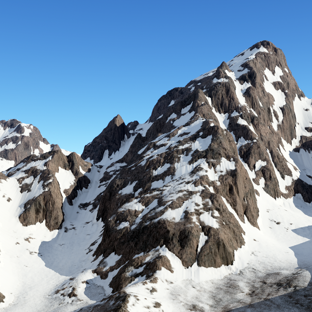
- Orometry-based Terrain Analysis and Synthesis
- auteur
- Oscar Argudo, Eric Galin, Adrien Peytavie, Axel Paris, James Gain, Eric Guérin
- resume
- Mountainous digital terrains are an important element of many virtual environments and find application in games, film, simulation and training. Unfortunately, while existing synthesis methods produce locally plausible results they often fail to respect global structure. This is exacerbated by a dearth of automated metrics for assessing terrain properties at a macro level. We address these issues by building on techniques from orometry, a field that involves the measurement of mountains and other relief features. First, we construct a sparse metric computed on the peaks and saddles of a mountain range and show that, when used for classification, this is capable of robustly distinguishing between different mountain ranges. Second, we present a synthesis method that takes a coarse elevation map as input and builds a graph of peaks and saddles respecting a given orometric distribution. This is then expanded into a fully continuous elevation function by deriving a consistent river network and shaping the valley slopes. In terms of authoring, users provide various control maps and are also able to edit, reposition, insert and remove terrain features all while retaining the characteristics of a selected mountain range. The result is a terrain analysis and synthesis method that considers and incorporates orometric properties, and is, on the basis of our perceptual study, more visually plausible than existing terrain generation methods.
- Accès au texte intégral et bibtex
-

-
- titre
- Procedural Riverscapes
- auteur
- Adrien Peytavie, Thibault Dupont, Eric Guérin, Yann Cortial, Benes Benes, James Gain, Eric Galin
- resume
- This paper addresses the problem of creating animated riverscapes through a novel procedural framework that generates the inscribing geometry of a river network and then synthesizes matching real-time water movement animation. Our approach takes bare-earth heightfields as input, derives hydrologically-inspired river network trajectories, carves riverbeds into the terrain, and then automatically generates a corresponding blend-flow tree for the water surface. Characteristics, such as the riverbed width, depth and shape, as well as elevation and flow of the fluid surface, are procedurally derived from the terrain and river type. The riverbed is inscribed by combining compactly supported elevation modifiers over the river course. Subsequently, the water surface is defined as a time-varying continuous function encoded as a blend-flow tree with leaves that are parameterized procedural flow primitives and internal nodes that are blend operators. While river generation is fully automated, we also incorporate intuitive interactive editing of both river trajectories and individual riverbed and flow primitives. The resulting framework enables the generation of a wide range of river forms, ranging from slow meandering rivers to rapids with churning water, including surface effects, such as foam and leaves carried downstream.
- Accès au texte intégral et bibtex
-

-
- titre
- A Psychophysical Evaluation of Texture Compression Masking Effects
- auteur
- Guillaume Lavoué, Michael Langer, Adrien Peytavie, Pierre Poulin
- resume
- Lossy texture compression is increasingly used to reduce GPU memory and bandwidth consumption. However, as raised by recent studies, evaluating the quality of compressed textures is a difficult problem. Indeed using Peak Signal-to-Noise Ratio (PSNR) on texture images, like done in most applications, may not be a correct way to proceed. In particular, there is evidence that masking effects apply when the texture image is mapped on a surface and combined with other textures (e.g., affecting geometry or normal). These masking effects have to be taken into account when compressing a set of texture maps, in order to have a real understanding of the visual impact of the compression artifacts on the rendered images. In this work, we present the first psychophysical experiment investigating the perceptual impact of texture compression on rendered images. We explore the influence of compression bit rate, light direction, and diffuse and normal map content on the visual impact of artifacts. The collected data reveal huge masking effects from normal map to diffuse map artifacts and vice versa, and reveal the weakness of PSNR applied on individual textures for evaluating compression quality. The results allow us to also analyze the performance and failures of image quality metrics for predicting the visibility of these artifacts. We finally provide some recommendations for evaluating the quality of texture compression and show a practical application to approximating the distortion measured on a rendered 3D shape.
- Accès au texte intégral et bibtex
-

-
- titre
- Terrain Amplification with Implicit 3D Features
- auteur
- Axel Paris, Eric Galin, Adrien Peytavie, Eric Guérin, James Gain
- resume
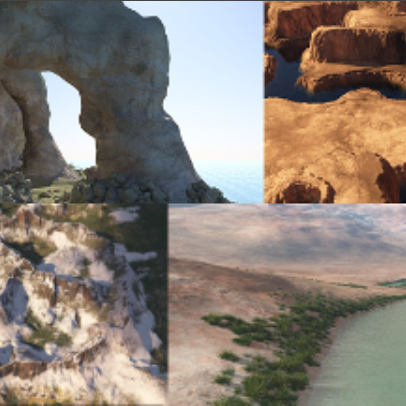
- While three-dimensional landforms, such as arches and overhangs, occupy a relatively small proportion of most computer generated landscapes, they are distinctive and dramatic and have an outsize visual impact. Unfortunately, the dominant heightfield representation of terrain precludes such features, and existing in-memory volumetric structures are too memory intensive to handle larger scenes. In this paper, we present a novel memory-optimized paradigm for representing and generating volumetric terrain based on implicit surfaces. We encode feature shapes and terrain geology using construction trees that arrange and combine implicit primitives. The landform primitives themselves are positioned using Poisson sampling, built using open shape grammars guided by stratified erosion and invasion percolation processes, and, finally, queried during polygonization. Users can also interactively author landforms using high-level modeling tools to create or edit the underlying construction trees, with support for iterative cycles of editing and simulation. We demonstrate that our framework is capable of importing existing large-scale heightfield terrains and amplifying them with such diverse structures as slot canyons, sea arches, stratified cliffs, fields of hoodoos, and complex karst cave networks.
- Accès au texte intégral et bibtex
-

-
- titre
- SPOT: Sliced Partial Optimal Transport
- auteur
- Nicolas Bonneel, David Coeurjolly
- resume
- Optimal transport research has surged in the last decade with wide applications in computer graphics. In most cases, however, it has focused on the special case of the so-called ``balanced'' optimal transport problem, that is, the problem of optimally matching positive measures of equal total mass. While this approach is suitable for handling probability distributions as their total mass is always equal to one, it precludes other applications manipulating disparate measures. Our paper proposes a fast approach to the optimal transport of constant distributions supported on point sets of different cardinality via one-dimensional slices. This leads to one-dimensional partial assignment problems akin to alignment problems encountered in genomics or text comparison. Contrary to one-dimensional balanced optimal transport that leads to a trivial linear-time algorithm, such partial optimal transport, even in 1-d, has not seen any closed-form solution nor very efficient algorithms to date. We provide the first efficient 1-d partial optimal transport solver. Along with a quasilinear time problem decomposition algorithm, it solves 1-d assignment problems consisting of up to millions of Dirac distributions within fractions of a second in parallel. We handle higher dimensional problems via a slicing approach, and further extend the popular iterative closest point algorithm using optimal transport -- an algorithm we call Fast Iterative Sliced Transport. We illustrate our method on computer graphics applications such a color transfer and point cloud registration.
- Accès au texte intégral et bibtex
-

-
- titre
- A Review of Digital Terrain Modeling
- auteur
- Eric Galin, Eric Guérin, Adrien Peytavie, Guillaume Cordonnier, Marie-Paule Cani, Bedrich Benes, James Gain
- resume
- Terrains are a crucial component of three-dimensional scenes and are present in many Computer Graphics applications. Terrain modeling methods focus on capturing landforms in all their intricate detail, including eroded valleys arising from the interplay of varied phenomena, dendritic mountain ranges, and complex river networks. Set against this visual complexity is the need for user control over terrain features, without which designers are unable to adequately express their artistic intent. This article provides an overview of current terrain modeling and authoring techniques, organized according to three categories: procedural modeling, physically-based simulation of erosion and land formation processes, and example-based methods driven by scanned terrain data. We compare and contrast these techniques according to several criteria, specifically: the variety of achievable landforms; realism from both a perceptual and geomorphological perspective; issues of scale in terms of terrain extent and sampling precision; the different interaction metaphors and attendant forms of user-control, and computation and memory performance. We conclude with an in-depth discussion of possible research directions and outstanding technical and scientific challenges.
- Accès au texte intégral et bibtex
-
-
- titre
- Procedural Tectonic Planets
- auteur
- Yann Cortial, Adrien Peytavie, Eric Galin, Eric Guérin
- resume
- We present a procedural method for authoring synthetic tectonic planets. Instead of relying on computationally demanding physically-based simulations, we capture the fundamental phenomena into a procedural method that faithfully reproduces large-scale planetary features generated by the movement and collision of the tectonic plates. We approximate complex phenomena such as plate subduction or collisions to deform the lithosphere, including the continental and oceanic crusts. The user can control the movement of the plates, which dynamically evolve and generate a variety of landforms such as continents, oceanic ridges, large scale mountain ranges or island arcs. Finally, we amplify the large-scale planet model with either procedurally-defined or real-world elevation data to synthesize coherent detailed reliefs. Our method allows the user to control the evolution of an entire planet interactively, and to trigger specific events such as catastrophic plate rifting.
- Accès au texte intégral et bibtex
-

Conference papers
-
- titre
- PC-MSDM: A quality metric for 3D point clouds
- auteur
- Gabriel Meynet, Julie Digne, Guillaume Lavoué
- resume
- In this paper, we present PC-MSDM, an objective metric for visual quality assessment of 3D point clouds. This full-reference metric is based on local curvature statistics and can be viewed as an extension for point clouds of the MSDM metric suited for 3D meshes. We evaluate its performance on an open subjective dataset of point clouds compressed by octree pruning; results show that the proposed metric outperforms its counterparts in terms of correlation with mean opinion scores.
- Accès au texte intégral et bibtex
-

- titre
- Dendry: A Procedural Model for Dendritic Patterns
- auteur
- Mathieu Gaillard, Bedrich Benes, Eric Guérin, Eric Galin, Damien Rohmer, Marie-Paule Cani
- Accès au bibtex
-
-
- titre
- mpLBP: An Extension of the Local Binary Pattern to Surfaces based on an Efficient Coding of the Point Neighbours
- auteur
- Elia Moscoso Thompson, Silvia Biasotti, Julie Digne, Raphaëlle Chaine
- resume
- The description of surface textures in terms of repeated colorimetric and geometric local surface variations is a crucial task for several applications, such as object interpretation or style identification. Recently, methods based on extensions to the surface meshes of the Local Binary Pattern (LBP) or the Scale-Invariant Feature Transform (SIFT) descriptors have been proposed for geometric and colorimetric pattern retrieval and classification. With respect to the previous works, we consider a novel LBPbased descriptor based on the assignment of the point neighbours into sectors of equal area and a non-uniform, multiple ring sampling. Our method is able to deal with surfaces represented as point clouds. Experiments on different benchmarks confirm the competitiveness of the method within the existing literature, in terms of accuracy and computational complexity.
- Accès au texte intégral et bibtex
-

Theses
-
- titre
- Local surface analysis with the Wavejets function basis : definition of new integral invariants and application to geometric details amplification
- auteur
- Yohann Béarzi
- resume
- Surface analysis is a challenging research topic, which has gathered a lot of interest over the last few decades. When surface data is given as a set of points, which are the typical output of 3D laser scanners, the lack of structure makes it even more challenging. In this thesis, we tackle surface analysis by introducing a new function basis: the Wavejets. This basis allows to decompose locally the surface into a radial polynomial component and an angular frequency component. Stability properties with regards to a bad normal direction are demonstrated. By linking Wavejets coefficients to a high order differential tensor, we also define high order principal directions on the surface. Furthermore, locally splitting surfaces with respect to frequencies leads us to define new integral invariants, permitting to locally describe the surface. Such descriptors are quite robust since they result from an integration process. Finally, we develop an application of these new integral invariants for geometric detail amplification, either based on point position or on normal direction modification, creating in this case the illusion of a surface change
- Accès au texte intégral et bibtex
-

-
- titre
- Procedural generation of atmospheric effects
- auteur
- Antoine Webanck
- resume
- This thesis focusses on the synthetization of natural landscapes, and more particularly on their celestial part. The aspect of the sky is governed by plenty of atmospheric phenomena, among which clouds play a major role for they are recurrent and widespread. Even without directly considering the sky, the density of the clouds allows them to intensely modify the global illumination of a landscape. The work of this thesis thus focuses mainly on the editing, modelling and animation of cloud areas of landscape dimensions.Because the thermodynamic simulation of cloud formation is hard to control and its maximum resolution quickly limits the details of the simulated volume, we propose instead a procedural generation method. We build a lightweight cloudscape model as a hierarchy of functions. The finest details are obtained by composing procedural noises and reproduce the specific shapes of different kinds of clouds. The large-scale cloud presence is described at a high level and at different times by maps drawn by the user. These discrete maps are transformed into implicit static primitives and then interpolated by morphing, accounting for relief and winds in order to produce coherent trajectories. The implicit field obtained by mixing the interpolating primitives represents the spatiotemporal field of cloud density. Images are finally synthesized by rendering of the atmospheric participative medium according to our own implementation, executed in parallel on a graphic card
- Accès au texte intégral et bibtex
-

2018
Journal articles
- titre
- Visualisation and personalisation of multi-representations city models
- auteur
- Jérémy Gaillard, Adrien Peytavie, Gilles Gesquière
- Accès au bibtex
-
-
- titre
- Mumford-Shah Mesh Processing using the Ambrosio-Tortorelli Functional
- auteur
- Nicolas Bonneel, David Coeurjolly, Pierre Gueth, Jacques-Olivier Lachaud
- resume
- The Mumford-Shah functional approximates a function by a piecewise smooth function. Its versatility makes it ideal for tasks such as image segmentation or restoration, and it is now a widespread tool of image processing. Recent work has started to investigate its use for mesh segmentation and feature lines detection, but we take the stance that the power of this functional could reach far beyond these tasks and integrate the everyday mesh processing toolbox. In this paper, we discretize an Ambrosio-Tortorelli approximation via a Discrete Exterior Calculus formulation. We show that, combined with a new shape optimization routine, several mesh processing problems can be readily tackled within the same framework. In particular, we illustrate applications in mesh denoising, normal map embossing, mesh inpainting and mesh segmentation.
- Accès au texte intégral et bibtex
-

- titre
- UrbanCo2Fab: Comprehension of Concurrent Viewpoints of Urban Fabric Based on Git
- auteur
- John Samuel Samuel, Sylvie Servigne, Gilles Gesquière
- resume
- The study of urban evolution requires representation and management of concurrent points of view using interoperable standards. An extension to CityGML has been recently proposed (Chaturvedi et al., 2017) to represent urban evolution. In this article, we further extend this work to represent different possible scenarios . The key characteristic of our approach is that it makes the most of existing technologies like version control system so that users can easily work with our proposed extension. Our approach also lets the users add and even modify information to versions and version transitions of scenarios in a given workspace.
- Accès au bibtex
-
-
- titre
- Sparse Geometric Representation Through Local Shape Probing
- auteur
- Julie Digne, Sébastien Valette, Raphaëlle Chaine
- resume
- We propose a new shape analysis approach based on the non-local analysis of local shape variations. Our method relies on a novel description of shape variations, called Local Probing Field (LPF), which describes how a local probing operator transforms a pattern onto the shape. By carefully optimizing the position and orientation of each descriptor, we are able to capture shape similarities and gather them into a geometrically relevant dictionary over which the shape decomposes sparsely. This new representation permits to handle shapes with mixed intrinsic dimensionality (e.g. shapes containing both surfaces and curves) and to encode various shape features such as boundaries. Our shape representation has several potential applications; here we demonstrate its efficiency for shape resampling and point set denoising for both synthetic and real data. Index Terms—Shape similarity-Local shape descriptor-Point set denoising and resampling.
- Accès au texte intégral et bibtex
-

-
- titre
- Sculpting Mountains: Interactive Terrain Modeling Based on Subsurface Geology
- auteur
- Guillaume Cordonnier, Marie-Paule Cani, Bedrich Benes, Jean Braun, Eric Galin
- resume
- Most mountain ranges are formed by the compression and folding of colliding tectonic plates. Subduction of one plate causes large-scale asymmetry while their layered composition (or stratigraphy) explains the multi-scale folded strata observed on real terrains. We introduce a novel interactive modeling technique to generate visually plausible, large scale terrains that capture these phenomena. Our method draws on both geological knowledge for consistency and on sculpting systems for user interaction. The user is provided hands-on control on the shape and motion of tectonic plates, represented using a new geologically-inspired model for the Earth crust. The model captures their volume preserving and complex folding behaviors under collision, causing mountains to grow. It generates a volumetric uplift map representing the growth rate of subsurface layers. Erosion and uplift movement are jointly simulated to generate the terrain. The stratigraphy allows us to render folded strata on eroded cliffs. We validated the usability of our sculpting interface through a user study, and compare the visual consistency of the earth crust model with geological simulation results and real terrains.
- Accès au texte intégral et bibtex
-

-
- titre
- Wavejets: A Local Frequency Framework for Shape Details Amplification
- auteur
- Yohann Béarzi, Julie Digne, Raphaëlle Chaine
- resume
- Detail enhancement is a well-studied area of 3D rendering and image processing, which has few equivalents for 3D shape processing. To enhance details, one needs an efficient analysis tool to express the local surface dynamics. We introduce Wavejets, a new function basis for locally decomposing a shape expressed over the local tangent plane, by considering both angular oscillations of the surface around each point and a radial polynomial. We link the Wavejets coefficients to surface derivatives and give theoretical guarantees for their precision and stability with respect to an approximate tangent plane. The coefficients can be used for shape details amplification, to enhance, invert or distort them, by operating either on the surface point positions or on the normals. From a practical point of view, we derive an efficient way of estimating Wavejets on point sets and demonstrate experimentally the amplification results with respect to noise or basis truncation.
- Accès au texte intégral et bibtex
-

-
- titre
- Interactive Generation of Time-evolving, Snow-Covered Landscapes with Avalanches
- auteur
- Guillaume Cordonnier, Pierre Ecormier, Eric Galin, James Gain, Bedrich Benes, Marie-Paule Cani
- resume
- We introduce a novel method for interactive generation of visually consistent, snow-covered landscapes and provide control of their dynamic evolution over time. Our main contribution is the real-time phenomenological simulation of avalanches and other user-guided events, such as tracks left by Nordic skiing, which can be applied to interactively sculpt the landscape. The terrain is modeled as a height field with additional layers for stable, compacted, unstable, and powdery snow, which behave in combination as a semi-viscous fluid. We incorporate the impact of several phenomena, including sunlight, temperature, prevailing wind direction, and skiing activities. The snow evolution includes snow-melt and snowdrift, which affect stability of the snow mass and the probability of avalanches. A user can shape landscapes and their evolution either with a variety of interactive brushes, or by prescribing events along a winter season time-line. Our optimized GPU-implementation allows interactive updates of snow type and depth across a large (10 × 10 km) terrain, including real-time avalanches, making this suitable for visual assets in computer games. We evaluate our method through perceptual comparison against exiting methods and real snow-depth data.
- Accès au texte intégral et bibtex
-
-
- titre
- Procedural Cloudscapes
- auteur
- Antoine Webanck, Yann Cortial, Eric Guérin, Eric Galin
- resume
- We present a phenomenological approach for modeling and animating cloudscapes. We propose a compact procedural model for representing the different types of cloud over a range of altitudes. We define primitive-based field functions that allow the user to control and author the cloud cover over large distances easily. Our approach allows us to animate cloudscapes by morphing: instead of simulating the evolution of clouds using a physically-based simulation, we compute the movement of clouds using key-frame interpolation and tackle the morphing problem as an Optimal Transport problem. The trajectories of the cloud cover primitives are generated by solving an Anisotropic Shortest Path problem with a cost function that takes into account the elevation of the terrain and the parameters of the wind field.
- Accès au texte intégral et bibtex
-

-
- titre
- Super-resolution of Point Set Surfaces using Local Similarities
- auteur
- Azzouz Hamdi-Cherif, Julie Digne, Raphaëlle Chaine
- resume
- 3D scanners provide a virtual representation of object surfaces at some given precision that depends on many factors such as the object material, the quality of the laser-ray or the resolution of the camera. This precision may even vary over the surface, depending for example on the distance to the scanner which results in uneven and unstructured point sets, with an uncertainty on the coordinates. To enhance the quality of the scanner output, one usually resorts to local surface interpolation between measured points. However, object surfaces often exhibit interesting statistical features such as repetitive geometric textures. Building on this property, we propose a new approach for surface super-resolution that detects repetitive patterns or self-similarities and exploits them to improve the scan resolution by aggregating scattered measures. In contrast with other surface super-resolution methods, our algorithm has two important advantages. First, when handling multiple scans, it does not rely on surface registration. Second, it is able to produce super-resolution from even a single scan. These features are made possible by a new local shape description able to capture differential properties of order above 2. By comparing those descriptors, similarities are detected and used to generate a high-resolution surface. Our results show a clear resolution gain over state-of-the-art interpolation methods.
- Accès au texte intégral et bibtex
-

Conference papers
-
- titre
- Amplification de Terrains avec des caractéristiques implicites 3D
- auteur
- Axel Paris, Eric Galin, Adrien Peytavie, Eric Guérin, J Gain
- resume
- While three-dimensional landforms, such as arches and overhangs, occupy a relatively small proportion of most computer-generated landscapes, they are distinctive and dramatic and have an outsize visual impact. Unfortunately, the dominant heightfield representation of terrain precludes such features, and existing in-memory volumetric structures are too memory intensive to handle larger scenes. In this paper, we present a novel memory-optimized paradigm for representing and generating volumetric terrain based on implicit surfaces. We encode feature shape and terrain geology using construction trees that arrange and combine implicit primitives. The landform primitives themselves are positioned using Poisson sampling, built using open shape grammars guided by stratified erosion and invasion percolation processes, and, finally, queried during polygonization.
- Accès au texte intégral et bibtex
-

-
- titre
- Correcting Motion Distortions in Time-of-Flight Imaging
- auteur
- Beatrix-Emőke Fülöp-Balogh, Nicolas Bonneel, Julie Digne
- resume
- Time-of-flight point cloud acquisition systems have grown in precision and robustness over the past few years. However, even subtle motion can induce significant distortions due to the long acquisition time. In contrast, there exists sensors that produce depth maps at a higher frame rate, but they suffer from low resolution and accuracy. In this paper, we correct distortions produced by small motions in time-of-flight acquisitions and even output a corrected animated sequence by combining a slow but high-resolution time-of-flight LiDAR system and a fast but low-resolution consumer depth sensor. We cast the problem as a curve-to-volume registration, by seeing a LiDAR point cloud as a curve in a 4-dimensional spacetime and the captured low-resolution depth video as a 4-dimensional spacetime volume. Our approach starts by registering both captured sequences in 4D, in a coarse-to-fine approach. It then computes an optical flow between the low-resolution frames and finally transfers high-resolution details by advecting along the flow. We demonstrate the efficiency of our approach on both synthetic data, on which we can compute registration errors, and real data.
- Accès au texte intégral et bibtex
-

Habilitation à diriger des recherches
-
- titre
- Optimal Transport for Computer Graphics and Temporal Coherence of Image Processing Algorithms
- auteur
- Nicolas Bonneel
- Accès au texte intégral et bibtex
-

-
- titre
- Contributions to local and non-local surface analysis
- auteur
- Julie Digne
- resume
- Following the recent progress of surface acquisition systems, geometry processing algorithms quickly evolve to deal with the variety of data types and acquisition quality. This habilitation manuscript details some recent approaches to tackle this challenge. First, for low-quality data, it is necessary to improve the measure by denoising or super-resolution algorithms. Self-similarity analysis yields efficient methods for improving the acquisition quality either for real object surfaces, or generalized shapes (shapes whose intrinsic dimension is not constant). Beyond low-resolution acquisition, taking this similarity into account also permits to compress point set surfaces, that can then be resampled during decompression. While geometric data are \emph{per se} a research topic, additional image data or other type of measures can be acquired simultaneously, which allows to complete or augment the geometric information through a joint analysis. This manuscript addresses this multi-captor data problem to augment urban scenes point sets by using a collection of pictures, which permits to colorize point clouds, once images are accurately registered. Finally, for specific purposes, it is interesting to represent surfaces as polygonal meshes potentially replacing several points by a single planar facet. To do so, this manuscript describes an Optimal Transportation metric between the initial point cloud and a mesh. The reconstruction and optimization of the mesh can then be driven by the minimization of this distance.
- Accès au texte intégral et bibtex
-

Preprints, Working Papers, ...
-
- titre
- Mumford-Shah Mesh Processing using the Ambrosio-Tortorelli Functional
- auteur
- Nicolas Bonneel, David Coeurjolly, Pierre Gueth, Jacques-Olivier Lachaud
- resume
- The Mumford-Shah functional approximates a function by a piecewise smooth function. Its versatility makes it ideal for tasks such as image segmentation or restoration, and it is now a widespread tool of image processing. Recent work has started to investigate its use for mesh segmentation and feature lines detection, but we take the stance that the power of this functional could reach far beyond these tasks and integrate the everyday mesh processing toolbox. In this paper, we discretize an Ambrosio-Tortorelli approximation via a Discrete Exterior Calculus formulation. We show that, combined with a new shape optimization routine, several mesh processing problems can be readily tackled within the same framework. In particular, we illustrate applications in mesh denoising, normal map embossing, mesh inpainting and mesh segmentation.
- Accès au texte intégral et bibtex
-

2017
Journal articles
-
- titre
- Authoring Landscapes by Combining Ecosystem and Terrain Erosion Simulation
- auteur
- Guillaume Cordonnier, Eric Galin, James Gain, Bedrich Benes, Eric Guérin, Adrien Peytavie, Marie-Paule Cani
- resume
- We introduce a novel framework for interactive landscape authoring that supports bi-directional feedback between erosion and vegetation simulation. Vegetation and terrain erosion have strong mutual impact and their interplay innuences the overall realism of virtual scenes. Despite their importance, these complex interactions have been neglected in computer graphics. Our framework overcomes this by simulating the eeect of a variety of geomor-phological agents and the mutual interaction between diierent material and vegetation layers, including rock, sand, humus, grass, shrubs, and trees. Users are able to exploit these interactions with an authoring interface that consistently shapes the terrain and populates it with details. Our method, validated through side-by-side comparison with real terrains, can be used not only to generate realistic static landscapes, but also to follow the temporal evolution of a landscape over a few centuries.
- Accès au texte intégral et bibtex
-

- titre
- Le transport optimal pour des applications en informatique graphique
- auteur
- Nicolas Bonneel
- resume
- Le transport optimal est une théorie mathématique qui permet de comparer deux histogrammes. Ceci dit, pourquoi s'intéresser aux histogrammes ?
- Accès au bibtex
-
-
- titre
- Intrinsic Decompositions for Image Editing
- auteur
- Nicolas Bonneel, Balazs Kovacs, Sylvain Paris, Kavita Bala
- resume
- Intrinsic images are a mid-level representation of an image that decompose the image into reflectance and illumination layers. The reflectance layer captures the color/texture of surfaces in the scene, while the illumination layer captures shading effects caused by interactions between scene illumination and surface geometry. Intrinsic images have a long history in computer vision and recently in computer graphics, and have been shown to be a useful representation for tasks ranging from scene understanding and reconstruction to image editing. In this report, we review and evaluate past work on this problem. Specifically, we discuss each work in terms of the priors they impose on the intrinsic image problem. We introduce a new synthetic ground-truth dataset that we use to evaluate the validity of these priors and the performance of the methods. Finally, we evaluate the performance of the different methods in the context of image-editing applications.
- Accès au texte intégral et bibtex
-

-
- titre
- Consistent Video Filtering for Camera Arrays
- auteur
- Nicolas Bonneel, James Tompkin, Deqing Sun, Oliver Wang, Kalyan Sunkavalli, Sylvain Paris, Hanspeter Pfister
- resume
- Visual formats have advanced beyond single-view images and videos: 3D movies are commonplace, researchers have developed multi-view navigation systems, and VR is helping to push light field cameras to mass market. However, editing tools for these media are still nascent, and even simple filtering operations like color correction or stylization are problematic: naively applying image filters per frame or per view rarely produces satisfying results due to time and space inconsistencies. Our method preserves and stabilizes filter effects while being agnostic to the inner working of the filter. It captures filter effects in the gradient domain, then uses \emph{input} frame gradients as a reference to impose temporal and spatial consistency. Our least-squares formulation adds minimal overhead compared to naive data processing. Further, when filter cost is high, we introduce a filter transfer strategy that reduces the number of per-frame filtering computations by an order of magnitude, with only a small reduction in visual quality. We demonstrate our algorithm on several camera array formats including stereo videos, light fields, and wide baselines.
- Accès au texte intégral et bibtex
-

-
- titre
- Fine scale image registration in large-scale urban LIDAR point sets
- auteur
- Maximilien Guislain, Julie Digne, Raphaëlle Chaine, Gilles Monnier
- resume
- Urban scenes acquisition is very often performed using laser scanners onboard a vehicle. In parallel, color information is also acquired through a set of coarsely aligned camera pictures. The question of combining both measures naturally arises for adding color to the 3D points or enhancing the geometry, but it faces important challenges. Indeed, 3D geometry acquisition is highly accurate while the images suffer from distortion and are only coarsely registered to the geometry. In this paper, we introduce a two-step method to register images to large-scale complex point clouds. Our method performs the image-to-geometry registration by iteratively registering the real image to a synthetic image obtained from the estimated camera pose and the point cloud, using either reflectance or normal information. First a coarse registration is performed by generating a wide-angle synthetic image and considering that small pitch and yaw rotations can be estimated as translations in the image plane. Then a fine registration is performed using a new image metric which is adapted to the difference of modality between the real and synthetic images. This new image metric is more resilient to missing data and large transformations than standard Mutual Information. In the process, we also introduce a method to generate synthetic images from a 3D point cloud that is adapted to large-scale urban scenes with occlusions and sparse areas. The efficiency of our algorithm is demonstrated both qualitatively and quantitatively on datasets of urban scans and associated images.
- Accès au texte intégral et bibtex
-

-
- titre
- The Bilateral Filter for Point Clouds
- auteur
- Julie Digne, Carlo de Franchis
- resume
- Point sets obtained by 3D scanners are often corrupted with noise, that can have several causes, such as a tangential acquisition direction, changing environmental lights or a reflective object material. It is thus crucial to design efficient tools to remove noise from the acquired data without removing important information such as sharp edges or shape details. To do so, Fleish-man et al. introduced a bilateral filter for meshes adapted from the bilateral filter for gray level images. This anisotropic filter denoises a point with respect to its neighbors by considering not only the distance from the neighbors to the point but also the distance along a normal direction. This simple fact allows for a much better preservation of sharp edges. In this paper, we analyze a parallel implementation of the bilateral filter adapted for point clouds. Source Code The ANSI C++ source code permitting to reproduce results from the on-line demo is available on the web page of the article 1 .
- Accès au texte intégral et bibtex
-

-
- titre
- Reconstructing 3D Building Models with the 2D Cadastre for Semantic Enhancement
- auteur
- Frédéric Pedrinis, Gilles Gesquière
- resume
- Virtual city models are increasingly used in urban land management processes, which involve the use of different sources of spatial information. This heterogeneous data is, however, often complementary and it may be necessary to give the possibility to join information provided by different sources. This paper presents a method to enhance 3D buildings by using usual 2D vectorial polygon database. These polygons may represent districts, building footprints, or any seg-mentation of the urban area that adds information to the city model. The enhancement consists in using this polygon database to split the 3D buildings into a set of city objects where each element possesses a 3D geometry and the semantic information of the polygon it is linked to. In this paper, for an illustration purpose, we will present how to create this link between 3D buildings and the cadastre map, in order to create a set of semantically rich 3D building models.
- Accès au texte intégral et bibtex
-

-
- titre
- Interactive Example-Based Terrain Authoring with Conditional Generative Adversarial Networks
- auteur
- Eric Guérin, Julie Digne, Eric Galin, Adrien Peytavie, Christian Wolf, Bedrich Benes, Benoît Martinez
- resume
- Authoring virtual terrains presents a challenge and there is a strong need for authoring tools able to create realistic terrains with simple user-inputs and with high user control. We propose an example-based authoring pipeline that uses a set of terrain synthesizers dedicated to specific tasks. Each terrain synthesizer is a Conditional Generative Adversarial Network trained by using real-world terrains and their sketched counterparts. The training sets are built automatically with a view that the terrain synthesizers learn the generation from features that are easy to sketch. During the authoring process, the artist first creates a rough sketch of the main terrain features, such as rivers, valleys and ridges, and the algorithm automatically synthesizes a terrain corresponding to the sketch using the learned features of the training samples. Moreover, an erosion synthesizer can also generate terrain evolution by erosion at a very low computational cost. Our framework allows for an easy terrain authoring and provides a high level of realism for a minimum sketch cost. We show various examples of terrain synthesis created by experienced as well as inexperienced users who are able to design a vast variety of complex terrains in a very short time.
- Accès au texte intégral et bibtex
-

-
- titre
- Coherent multi-layer landscape synthesis
- auteur
- Oscar Argudo, Carlos Andujar, Antonio Chica, Eric Guérin, Julie Digne, Adrien Peytavie, Eric Galin
- resume
- We present an efficient method for generating coherent multi-layer landscapes. We use a dictionary built from exemplars to synthesize high-resolution fully featured terrains from input low-resolution elevation data. Our example-based method consists in analyzing real-world terrain examples and learning the procedural rules directly from these inputs. We take into account not only the elevation of the terrain, but also additional layers such as the slope, orientation, drainage area, the density and distribution of vegetation, and the soil type. By increasing the variety of terrain exemplars, our method allows the user to synthesize and control different types of landscapes and biomes, such as temperate or rain forests, arid deserts and mountains.
- Accès au texte intégral et bibtex
-

Conference papers
-
- titre
- Modélisation procédurale de nuages multigenre
- auteur
- Yann Cortial, Antoine Webanck, Eric Guérin, Adrien Peytavie, Eric Galin
- resume
- La modélisation et le rendu de phénomènes atmosphériques reste un problème ouvert en informatique graphique. L'étendue spatiale ainsi que la complexité des effets lumineux sont particulièrement difficiles à modéliser et à simuler. Dans ce travail, nous proposons un nouveau modèle de représentation de nuages multigenre par com-binaison de bruits complexes. Le rendu est assuré par une méthode de single scattering qui prend en compte les nuages ainsi que l'atmosphère, avec une contribution ambiante du ciel environnant ainsi que la traversée des nuages. Nous utilisons une approximation analytique de la fonction de phase des nuages issue des travaux en physique. Cette approche procédurale se prête bien à l'animation et offre un bon niveau de contrôle utilisateur : nous le démontrons par la mise en place et le rendu d'un front météorologique complet combinant des cirrus, cirrostratus, altostratus, altocumulus, stratocumulus, cumulus et cumulonimbus.
- Accès au texte intégral et bibtex
-

-
- titre
- Optimal transport-based dictionary learning and its application to Euclid-like Point Spread Function representation
- auteur
- Morgan A Schmitz, Matthieu Heitz, Nicolas Bonneel, Fred Maurice Ngolè Mboula, David Coeurjolly, Marco Cuturi, Gabriel Peyré, Jean-Luc Starck
- resume
- Optimal Transport theory enables the definition of a distance across the set of measures on any given space. This Wasserstein distance naturally accounts for geometric warping between measures (including, but not exclusive to, images). We introduce a new, Optimal Transport-based representation learning method in close analogy with the usual Dictionary Learning problem. This approach typically relies on a matrix dot-product between the learned dictionary and the codes making up the new representation. The relationship between atoms and data is thus ultimately linear. By reconstructing our data as Wasserstein barycenters of learned atoms instead, our approach yields a representation making full use of the Wasserstein distance's attractive properties and allowing for non-linear relationships between the dictionary atoms and the datapoints. We apply our method to a dataset of Euclid-like simulated PSFs (Point Spread Function). ESA's Euclid mission will cover a large area of the sky in order to accurately measure the shape of billions of galaxies. PSF estimation and correction is one of the main sources of systematic errors on those galaxy shape measurements. PSF variations across the field of view and with the incoming light's wavelength can be highly non-linear, while still retaining strong geometrical information, making the use of Optimal Transport distances an attractive prospect. We show that our representation does indeed succeed at capturing the PSF's variations.
- Accès au texte intégral et bibtex
-

-
- titre
- A generic approach for sunlight and shadow impact computation on large city models
- auteur
- Vincent Jaillot, Frédéric Pedrinis, Sylvie Servigne, Gilles Gesquière
- resume
- Study of sunlight and shadow effects on the city has become more accessible with the development of 3D city models. It allows measuring when and how an object is exposed to the sunlight, which enables conducting many related studies such as energy analyses or urban planning. While many works have been done for this purpose, it may be interesting to know which objects (terrain, buildings, trees, etc.) prevent other objects from being exposed to the sunlight. In this paper we propose a method which detects the sunlit zones on a city model and the shadow impact of its objects. As these objects can be of various natures and as the acquisition processes varies from one city to another, they are not all necessarily available in each city model. Since an object’s shadow can impact other very distant objects, we must have a method that handles efficiently large areas, especially knowing that city models can have fine geometric and semantic definitions. The generic approach we propose can manage these different city models by supporting every type of the above-mentioned objects and by relying on the use of standards. This paper presents a generic method which allows sunlight and shadow computation on arbitrarily large 3D city models for impact analyses of each city object on its surroundings (close and far). This means that besides checking if a city object is shaded or not, we know which objects are responsible for the shade, thus allowing various impact analyses on cities.
- Accès au texte intégral et bibtex
-

-
- titre
- Semantic correspondence across 3D models for example-based modeling
- auteur
- Vincent Léon, Vincent Itier, Nicolas Bonneel, Guillaume Lavoué, Jean-Philippe Vandeborre
- resume
- Modeling 3D shapes is a specialized skill not affordable to most novice artists due to its complexity and tediousness. At the same time, databases of complex models ready for use are becoming widespread, and can help the modeling task in a process called example-based modeling. We introduce such an example-based mesh modeling approach which, contrary to prior work, allows for the replacement of any localized region of a mesh by a region of similar semantics (but different geometry) within a mesh database. For that, we introduce a selection tool in a space of semantic descriptors that co-selects areas of similar semantics within the database. Moreover, this tool can be used for part-based retrieval across the database. Then, we show how semantic information improves the assembly process. This allows for modeling complex meshes from a coarse geometry and a database of more detailed meshes, and makes modeling accessible to the novice user.
- Accès au texte intégral et bibtex
-

Book sections
-
- titre
- Managing Versions and History Within Semantic 3D City Models for the Next Generation of CityGML
- auteur
- Kanishk Chaturvedi, Carl Stephen Smyth, Gilles Gesquière, Tatjana Kutzner, Thomas H. Kolbe
- resume
- Semantic 3D city models describe city entities by objects with thematic and spatial attributes and their interrelationships. Today, more and more cities worldwide are representing their 3D city models according to the CityGML standard issued by the Open Geospatial Consortium (OGC). Various application areas of 3D city models such as urban planning or architecture require that authorities or stakeholders manage parallel alternative versions of city models and their evolution over time, which is currently not supported by the CityGML standard 2.0. In this paper, we propose a concept and a data model extending CityGML by denoting versions of models or model elements as planning alternatives. We support transitions between these versions to manage history or evolution of the city models over time. This approach facilitates the interoperable integration and exchange ofdifferent versions of a 3D city model within one dataset, including a possibly complex history of a repository. Such an integrated dataset can be used by different software systems to visualize and work with all the versions. The versions and version transitions in our proposed data model are bi-temporal in nature. They are defined as separate feature types, which allow the users to manage versioning and to perform queries about versions using an OGC Web Feature Service. We apply this data model to a use case of planning concurrent versions and demonstrate it with example instance data. The concept is general in the sense that it can be directly applied to other GML-based application schemas including the European INSPIRE data themes and national standards for topography and cadasters like the British Ordnance Survey Mastermap or the German cadaster standard ALKIS.
- Accès au texte intégral et bibtex
-

Habilitation à diriger des recherches
-
- titre
- Virtual land modeling
- auteur
- Eric Guérin
- Accès au texte intégral et bibtex
-

Other publications
- titre
- Representation and visualization of Documented Virtual Cities. LDAC2017 - 5th Linked Data in Architecture and Construction Workshop, Dijon, France, 13-15 November, 2017 - http://linkedbuildingdata.net/ldac2017/files/LDAC2017Report.pdf
- auteur
- John Samuel Samuel, Gilles Gesquière, Sylvie Servigne
- Accès au bibtex
-
Theses
-
- titre
- Joint point clouds and images processing for the analysis and visualization of 3D models
- auteur
- Maximilien Guislain
- resume
- Recent years saw a rapid development of city digitization technologies. Acquisition campaigns covering entire cities are now performed using LiDAR (Light Detection And Ranging) scanners embedded aboard mobile vehicles. These acquisition campaigns yield point clouds, composed of millions of points, representing the buildings and the streets, and may also contain a set of images of the scene. The subject developed here is the improvement of the point cloud using the information contained in the camera images. This thesis introduces several contributions to this joint improvement. The position and orientation of acquired images are usually estimated using devices embedded with the LiDAR scanner, even if this information is inaccurate. To obtain the precise registration of an image on a point cloud, we propose a two-step algorithm which uses both Mutual Information and Histograms of Oriented Gradients. The proposed method yields an accurate camera pose, even when the initial estimations are far from the real position and orientation. Once the images have been correctly registered, it is possible to use them to color each point of the cloud while using the variability of the point of view. This is done by minimizing an energy considering the different colors associated with a point and the potential colors of its neighbors. Illumination changes can also change the color assigned to a point. Notably, this color can be affected by cast shadows. These cast shadows are changing with the sun position, it is therefore necessary to detect and correct them. We propose a new method that analyzes the joint variation of the reflectance value obtained by the LiDAR and the color of the points. By detecting enough interfaces between shadow and light, we can characterize the luminance of the scene and to remove the cast shadows. The last point developed in this thesis is the densification of a point cloud. Indeed, the local density of a point cloud varies and is sometimes insufficient in certain areas. We propose a directly applicable approach to increase the density of a point cloud using multiple images
- Accès au texte intégral et bibtex
-

2016
Journal articles
-
- titre
- Integration of Multiple Heterogeneous and Autonomous Web Services using Mediation Approach: Open Challenges
- auteur
- John Samuel Samuel, Christophe Rey
- resume
- Regular users and enterprises are now increasingly dependent on web services. This growing dependence on one hand has simplified routine tasks, but on the other hand it has resulted in loss of direct control over the data. Nevertheless, both users and enterprises require simplified and generic solutions to access their data. The classical mediation approach from the data integration field provides a uniform query interface to diverse data sources hiding the underlying heterogeneity. But using this approach over multiple heterogeneous and autonomous web services has several open challenges. In this article, we will take a look at some of these challenges that need to be addressed for achieving a fully automated solution.
- Accès au texte intégral et bibtex
-

-
- titre
- Efficient modeling of entangled details for natural scenes
- auteur
- Eric Guérin, Eric Galin, François Grosbellet, Adrien Peytavie, Jean-David Genevaux
- resume
- Digital landscape realism often comes from the multitude of details that are hard to model such as fallen leaves, rock piles or entangled fallen branches. In this article, we present a method for augmenting natural scenes with a huge amount of details such as grass tufts, stones, leaves or twigs. Our approach takes advantage of the observation that those details can be approximated by replications of a few similar objects and therefore relies on mass-instancing. We propose an original structure, the Ghost Tile, that stores a huge number of overlapping candidate objects in a tile, along with a pre-computed collision graph. Details are created by traversing the scene with the Ghost Tile and generating instances according to user-defined density fields that allow to sculpt layers and piles of entangled objects while providing control over their density and distribution.
- Accès au texte intégral et bibtex
-

-
- titre
- Heterogeneous Sensor Data Exploration and Sustainable Declarative Monitoring Architecture: Application to Smart Building
- auteur
- Sylvie Servigne, Yann Gripay, Ozgun Pinarer, John Samuel Samuel, Atay Ozgovde, Jacques Jay
- resume
- Concerning energy consumption and monitoring architectures, our goal is to develop a sustainable declarative monitoring architecture for lower energy consumption taking into account the monitoring system itself. Our second is to develop theoretical and practical tools to model, explore and exploit heterogeneous data from various sources in order to understand a phenomenon like energy consumption of smart building vs inhabitants' social behaviours. We focus on a generic model for data acquisition campaigns based on the concept of generic sensor. The concept of generic sensor is centered on acquired data and on their inherent multi- dimensional structure, to support complex domain-specific or field-oriented analysis processes. We consider that a methodological breakthrough may pave the way to deep understanding of voluminous and heterogeneous scientific data sets. Our use case concerns energy efficiency of buildings to understand relationship between physical phenomena and user behaviors. The aim of this paper is to give a presentation of our methodology and results concerning architecture and user-centric tools.
- Accès au texte intégral et bibtex
-

-
- titre
- Volumetric Spot Noise for Procedural 3D Shell Texture Synthesis
- auteur
- Nicolas Pavie, Guillaume Gilet, Jean-Michel Dischler, Eric Galin, Djamchid Ghazanfarpour
- resume
- In this paper, we present an extension of the Locally Controlled Spot Noise and a visualization pipeline for volumetric fuzzy details synthesis. We extend the noise model to author volumetric fuzzy details using filtered 3D quadratic kernel functions convolved with a projective non-uniform 2D distribution of impulses. We propose a new method based on order independent splatting to compute a fast view dependent approximation of shell noise at interactive rates. Our method outperforms ray marching techniques and avoids aliasing artifacts, thus improving interactive content authoring feedback. Moreover, generated surface details share the same properties as procedural noise: they extend on potentially infinite surfaces, are defined in an extremely compact way, are non-repetitive, continuous (no discrete voxel-artifacts when zooming) and independent of the definition of the underlying surface (no surface parameterization is required).
- Accès au texte intégral et bibtex
-

- titre
- Sparse representation of terrains for procedural modeling
- auteur
- Eric Guérin, Julie Digne, Eric Galin, Adrien Peytavie
- resume
- In this paper, we present a simple and efficient method to represent terrains as elevation functions built from linear combinations of landform features (atoms). These features can be extracted either from real world data-sets or procedural primitives, or from any combination of multiple terrain models. Our approach consists in representing the elevation function as a sparse combination of primitives, a concept which we call Sparse Construction Tree, which blends the different landform features stored in a dictionary. The sparse representation allows us to represent complex terrains using combinations of atoms from a small dictionary, yielding a powerful and compact terrain representation and synthesis tool. Moreover, we present a method for automatically learning the dictionary and generating the Sparse Construction Tree model. We demonstrate the efficiency of our method in several applications: inverse procedural modeling of terrains, terrain amplification and synthesis from a coarse sketch.
- Accès au bibtex
-
-
- titre
- Large Scale Terrain Generation from Tectonic Uplift and Fluvial Erosion
- auteur
- Guillaume Cordonnier, Jean Braun, Marie-Paule Cani, Bedrich Benes, Eric Galin, Adrien Peytavie, Eric Guérin
- resume
- At large scale, landscapes result from the combination of two major processes: tectonics which generate the main relief through crust uplift, and weather which accounts for erosion. This paper presents the first method in computer graphics that combines uplift and hydraulic erosion to generate visually plausible terrains. Given a user-painted uplift map, we generate a stream graph over the entire domain embedding elevation information and stream flow. Our approach relies on the stream power equation introduced in geology for hydraulic erosion. By combining crust uplift and stream power erosion we generate large realistic terrains at a low computational cost. Finally, we convert this graph into a digital elevation model by blending landform feature kernels whose parameters are derived from the information in the graph. Our method gives high-level control over the large scale dendritic structures of the resulting river networks, watersheds, and mountains ridges.
- Accès au texte intégral et bibtex
-

-
- titre
- Wasserstein Barycentric Coordinates: Histogram Regression Using Optimal Transport
- auteur
- Nicolas Bonneel, Gabriel Peyré, Marco Cuturi
- resume
- This article defines a new way to perform intuitive and geometrically faithful regressions on histogram-valued data. It leverages the theory of optimal transport, and in particular the definition of Wasserstein barycenters, to introduce for the first time the notion of barycentric coordinates for histograms. These coordinates take into account the underlying geometry of the ground space on which the histograms are defined, and are thus particularly meaningful for applications in graphics to shapes, color or material modification. Beside this abstract construction, we propose a fast numerical optimization scheme to solve this backward problem (finding the barycentric coordinates of a given histogram) with a low computational overhead with respect to the forward problem (computing the barycenter). This scheme relies on a backward algorithmic differentiation of the Sinkhorn algorithm which is used to optimize the entropic regularization of Wasserstein barycenters. We showcase an illustrative set of applications of these Wasserstein coordinates to various problems in computer graphics: shape approximation, BRDF acquisition and color editing.
- Accès au texte intégral et bibtex
-

-
- titre
- Environmental Objects for Authoring Procedural Scenes
- auteur
- François Grosbellet, Adrien Peytavie, Eric Guérin, Eric Galin, Stéphane Mérillou, Bedrich Benes
- resume
- We propose a novel approach for authoring large scenes with automatic enhancement of objects to create geometric decoration details such as snow cover, icicles, fallen leaves, grass tufts or even trash. We introduce environmental objects that extend an input object geometry with a set of procedural effects that defines how the object reacts to the environment, and by a set of scalar fields that defines the influence of the object over of the environment. The user controls the scene by modifying environmental variables, such as temperature or humidity fields. The scene definition is hierarchical: objects can be grouped and their behaviours can be set at each level of the hierarchy. Our per object definition allows us to optimize and accelerate the effects computation, which also enables us to generate large scenes with many geometric details at a very high level of detail. In our implementation, a complex urban scene of 10 000 m², represented with details of less than 1 cm, can be locally modified and entirely regenerated in a few seconds.
- Accès au texte intégral et bibtex
-

-
- titre
- Continuous semantic description of 3D meshes
- auteur
- Vincent Léon, Nicolas Bonneel, Guillaume Lavoué, Jean-Philippe Vandeborre
- resume
- We propose a novel high-level signature for continuous semantic description of 3D shapes. Given an approximately segmented and labeled 3D mesh, our descriptor consists of a set of geodesic distances to the different semantic labels. This local multidimensional signature effectively captures both the semantic information (and relationships between labels) and the underlying geometry and topology of the shape. We illustrate its benefits on two applications: automatic semantic labeling, seen as an inverse problem along with supervised-learning, and semantic-aware shape editing for which the isocurves of our harmonic description are particularly relevant .
- Accès au texte intégral et bibtex
-

-
- titre
- Temporally Coherent Sculpture of Composite Objects
- auteur
- Artur P. Sampaio, Raphaëlle Chaine, Creto A.Vidal, Joaquim B. Cavalcante-Neto
- resume
- We address the problem of virtual sculpting and deformation of shapes composed of small, randomly placed objects. Objects may be tightly packed-such as pebbles, pills, seeds and grains, or be sparsely distributed with an overarching shape-such as flocks of birds or schools of fish. Virtual sculpture has rapidly become a standard in the entertainment industry. Composites, though, are still usually created in a static way by individually placing each object or by sculpting a support surface and procedurally populating the final shape. That raises problems for the generalisation to evolving shapes with visual continuity of the components. Large amounts of geometrical data are generated, and must be maintained and processed, both by the CPU and by the GPU. Whenever the shape is deformed, one has to define how these compositing objects should turn, displace or disappear inside the volume, as well as how new instances should become visible to the outside. It is difficult to rely on a physical system to perform that task in real time. The system we suggest can be constructed upon any uniform mesh-based representation that can be deformed and whose connectivity can be updated by operations such as edge splits, collapses, and flips. The mesh remains populated with an aperiodic distribution of composing elements that are automatically updated under deformation. The idea is to sculpt the shape as if it were filled with little objects, without handling the complexity of manipulating volumetric shapes. For this purpose, we suggest exploiting the properties of the uniform sampling of the surface. We show that we are able to properly handle virtual sculpting of composites in real-time and maintaining temporal continuity. This system also uses GPU optimisations to render individual elements efficiently. To our knowledge, no previous sculpting system allows the user to simultaneously see and sculpt agglomerates in such a fast and reliable fashion.
- Accès au texte intégral et bibtex
-

Conference papers
-
- titre
- An Automatic Comparison Approach to Detect Errors on 3D City Models
- auteur
- Benjamin Gorszczyk, Guillaume Damiand, Sylvie Servigne, Abdoulaye Abou Diakité, Gilles Gesquière
- resume
- 3D building models are needed in several professional domains. To provide better results, these models must be errors-freeand that is why it is required to have a way to detect and to correct errors. These errors can be geometric, topological orsemantic. By using a topological structure called EBM-LCC that allows to model buildings, we create a new tool that allowsto detect these three type of errors in 3D city models. The solution we propose is an algorithm that compares two EBM-LCC.This algorithm can be used to compare two different models, for example acquired with two different processes, or resultingfrom two different acquisition campaigns. It is also an interesting tool to compare and validate algorithms. In this work, wecompare an EBM-LCC loaded directly from a CityGML model with an EBM-LCC reconstructed from a soup of polygons only.Then we can use the result of this comparison to outline possible differences or to correct one of the two models by using theinformation of the other one. This algorithm allowed to automatically detect and correct semantic errors on several models thatare currently used by professionals. This shows the interest of EBM-LCC for the city modeling domain as it helps to reach anerror-free model.
- Accès au texte intégral et bibtex
-

-
- titre
- Visualization of Documented 3D Cities
- auteur
- Clément Chagnaud, John Samuel Samuel, Sylvie Servigne, Gilles Gesquière
- resume
- Documents whether historical photographs or urban regulations are important for understanding the urban past as well as for urban planning. CityGML is an open standard used to represent 3D structure and thematic information of the cities. In this article, we briefly present how the recent extension to CityGML to represent documents has been integrated to the 4D virtual urban environment. We will then focus on different visualization techniques of documents in this environment and the various metrics used to evaluate them.
- Accès au texte intégral et bibtex
-

-
- titre
- A data model for simulation models relying on spatio-temporal urban data
- auteur
- G G Langlois, Vincent Tourre, Myriam Servières, G G Gervais, Gilles Gesquière
- resume
- To understand the complexity of modern cities and anticipate their expansion, experts from various fields conceive simulation models that can be very different. Those simulation models work with a variety of data with their own organization. Furthermore, because the urban objects are studied in the context of the evolution of a city or urban area, they carry temporal and spatial information. In this paper, we present the base classes of a common data model robust and flexible enough to serve the identified use cases. We then introduce a mechanism that allows to add thematic information to those classes. We also present some possibilities of the use of the data model. We end this paper by evoking the future improvements of the data model.
- Accès au texte intégral et bibtex
-

-
- titre
- Automated Production of Interactive 3D Temporal Geovisualizations so as to Enhance Flood Risk Awareness
- auteur
- Florence Jacquinod, Frédéric Pedrinis, Jérémy Edert, Gilles Gesquière
- resume
- The FLOOD AR project originates from an explicitly expressed need for digital 3D temporal georeferenced models that can be largely diffused among riverside residents through computers and mobile devices, in order to support the raising of public awareness concerning flood risk along the Rhône river. This project is led by a multidisciplinary consortium of researchers from several fields who are working together to develop usable tools and models as well as recommendations regarding visual content, interfaces and context of use for those 3D models. As far as computer science is concerned, given the practical difficulties of resorting to 3D georeferenced technologies for practitioners and the current limitations of commonly used GIS data formats and tools, automatic tools allowing any interested parties to produce 3D temporal models in order to support flood risk awareness' enhancement were developed in the first phase of the project. The storage of those 3D models in an interoperable format (CityGML) ensures that those 3D temporal models are available for other purposes in relation to flood mitigation (regarding flood risk mitigation planning and public consultations or visual analysis for instance). Automating the production of 3D temporal models guarantees that those models can be produced for any territory along the Rhône river. A tool to visualize those 3D temporal models interactively will also be made available as an open source tool as part of the project.
- Accès au texte intégral et bibtex
-

-
- titre
- Surface derivatives computation using Fourier Transform
- auteur
- Yohann Béarzi, Julie Digne
- resume
- We present a method for computing high order derivatives on a smooth surface S at a point p by analyzing the vibrations of the surface along circles in the tangent plane, centered at p. By computing the Discrete Fourier Transform of the deviation of S from the tangent plane restricted to those circles, a linear relation between the Fourier coefficients and the derivatives can be expressed. Thus, given a smooth scalar field defined on the surface, all its derivatives at p can be computed simultaneously. The originality of this method is that no direct derivation process is applied to the data. Instead, integration is performed through the Discrete Fourier Transform, and the result is expressed as a one dimensional polynomial. We derive two applications of our framework namely normal correction and curvature estimation which we demonstrate on synthetic and real data.
- Accès au texte intégral et bibtex
-

-
- titre
- Detecting and Correcting Shadows in Urban Point Clouds and Image Collections
- auteur
- Maximilien Guislain, Julie Digne, Raphaëlle Chaine, Dimitri Kudelski, Pascal Lefebvre-Albaret
- resume
- LiDAR (Light Detection And Ranging) acquisition is a widespread method for measuring urban scenes, be it a small town neighborhood or an entire city. It is even more interesting when this acquisition is coupled with a collection of pictures registered with the data, permitting to recover the color information of the points. Yet, this added color can be perturbed by shadows that are very dependent on the sun direction and weather conditions during the acquisition. In this paper, we focus on the problem of automatically detecting and correcting the shadows from the LiDAR data by exploiting both the images and the point set laser reflectance. Building on the observation that shadow boundaries are characterized by both a significant color change and a stable laser reflectance, we propose to first detect shadow boundaries in the point set and then segment ground shadows using graph cuts in the image. Finally using a simplified illumination model we correct the shadows directly on the colored point sets. This joint exploitation of both the laser point set and the images renders our approach robust and efficient, avoiding user interaction.
- Accès au texte intégral et bibtex
-

-
- titre
- A Data Structure for Progressive Visualisation and Edition of Vectorial Geospatial Data
- auteur
- Jérémy Gaillard, Adrien Peytavie, Gilles Gesquière
- resume
- 3D mock-ups of cities are becoming an increasingly common tool for urban planning. Sharing the mock-up is still a challenge since the volume of data is so high. Furthermore, the recent surge in low-end, mobile devices requires developers to carefully control the amount of data they process. In this paper, we present a hierarchical data structure that allows the streaming of vectorial data. Loosely based on a quadtree, the structure stores the data in tiles and is organised following a weight function which allows the most relevant data to be displayed first. The relevance of a feature can be measured by its geometry and semantic attributes, and can vary depending on the application or client type. Tiles can be limited in size (number of features or triangles) for the client to be able to control resource consumption. The article also presents algorithms for the addition or removal of features in the data structure, opening the path for the interactive edition of city data stored in a database.
- Accès au texte intégral et bibtex
-

-
- titre
- Interactive Multicut Video Segmentation
- auteur
- Evgeny E Levinkov, James Tompkin, Nicolas Bonneel, Steffen Kirchhoff, Bjoern E Andres, Hanspeter Pfister
- resume
- Video segmentation requires separating foreground from background, but the general problem extends to more complicated scene segmentations of different objects and their multiple parts. We develop a new approach to interactive multi-label video segmentation where many objects are segmented simultaneously with consistent spatio-temporal boundaries, based on intuitive multi-colored brush scribbles. From these scribbles, we derive constraints to define a combinatorial problem known as the multicut—a problem notoriously difficult and slow to solve. We describe a solution using efficient heuristics to make multi-label video segmentation interactive. As our solution generalizes typical binary segmentation tasks, while also improving efficiency in multi-label tasks, our work shows the promise of multicuts for interactive video segmentation.
- Accès au texte intégral et bibtex
-

-
- titre
- Representation and Visualization of Urban Fabric through Historical Documents
- auteur
- John Samuel, Clémentine Périnaud, Georges Gay, Sylvie Servigne, Gilles Gesquière
- resume
- Documents serve an important role in understanding change in urban fabric. The available multidimensional (spatial, temporal and thematic) information in these documents narrate not only the various features of the elements of the urban fabric but also notifies their changes during time. CityGML standard is used to spatially and temporally represent the city objects. But it misses features to represent city lifecycle and its linked documents. The first part has been addressed recently. In this article, we propose an extension to CityGML standard to integrate city objects and relevant associated documents. Proposing a solution based on standards permits data interoperability. We also briefly describe how these documents are visualized in our current 3D urban environment prototype built over CityGML
- Accès au texte intégral et bibtex
-

- titre
- Challenges in Integrating Multiple Heterogeneous and Autonomous Web Services using Mediation Approach
- auteur
- John Samuel Samuel, Christophe Rey
- resume
- The use of diverse web services has simplified routine tasks but it has resulted in loss of direct control over the data. This shift from traditional self-controlled databases to heterogeneous, autonomous web services can be increasingly seen among small and medium scale enterprises. Enterprises depen- dent on web services require a generic approach to integrate with multiple web services. The classical mediation approach from the data integration field provides a uniform query interface to diverse data sources hiding the underlying heterogeneity, but its utilization with current generation web services API has several research and industrial challenges which will be described in this article.
- Accès au bibtex
-
- titre
- A Declarative Approach to Information Extraction Using Web Service API
- auteur
- John Samuel Samuel, Christophe Rey
- resume
- The number of diverse web services that we use regularly is significantly increasing. Most of these services are managed by autonomous service providers. However it has become very difficult to get a unified view of this widespread data, which in all likelihood is substantially important to enterprises. A classical approach followed by the enterprises is to write applications using imperative languages making use of the web service API. Such an approach is not scalable and is difficult to maintain considering the ever-evolving web services landscape. This tutorial explores a semi-automated declarative approach to information extraction from the web services using a classical virtual data integration approach, namely mediation, that relies on a well-known query rewriting algorithm, namely the inverse-rules algorithm. It is targeted to audience from both industry as well as academia and requires a basic understanding of database principles and web technologies.
- Accès au bibtex
-
- titre
- Assessing the privatization of skylines using 3D modelling: the case of Lyon
- auteur
- Florence Jacquinod, Gilles Gesquière, Frédéric Pedrinis
- Accès au bibtex
-
Other publications
- titre
- Recalage d'image dans des nuages de points de scènes urbaines
- auteur
- Maximilien Guislain, Julie Digne, Raphaëlle Chaine, Gilles Monnier
- Accès au bibtex
-
Poster communications
- titre
- FLOOD AR : utiliser des modèles 3D temporels interactifs pour la sensibilisation au risque d’inondation
- auteur
- Florence Jacquinod, Jérémy Edert, Gilles Gesquière, Marcel Vogt, Julia Bonaccorsi
- Accès au bibtex
-
- titre
- Generic Web Service Wrapper for Mediation based Data Warehousing
- auteur
- John Samuel Samuel, Christophe Rey
- resume
- The growing availability of specialized web services targeting only a particular niche has resulted in the use of multiple web services by enterprises for their daily activities. It is significantly difficult for resource-crunched small enterprises to write applications to integrate with each and every dependent web service. Overcoming the missing wide scale adoption of machine readable standards (WSDL, WADL, SAWSDL), we explore the capability to integrate with numerous web services using only the basic web standards (HTTP, JSON, XML, XSD, XSLT) and declarative languages (SQL, datalog queries). In this paper, we specifically focus on the role of a generic web service wrapper to support this declarative approach to describe, query and extract enterprise data from web services.
- Accès au bibtex
-
2015
Journal articles
-
- titre
- An Implementation and Parallelization of the Scale-Space Meshing Algorithm
- auteur
- Julie J. Digne
- resume
- Creating an interpolating mesh from an unorganized set of oriented points is a difficult problem which is often overlooked. Most methods focus indeed on building a watertight smoothed mesh by defining some function whose zero level set is the surface of the object. However in some cases it is crucial to build a mesh that interpolates the points and does not fill the acquisition holes: either because the data are sparse and trying to fill the holes would create spurious artifacts or because the goal is to explore visually the data exactly as they were acquired without any smoothing process. In this paper we detail a parallel implementation of the Scale-Space Meshing algorithm, which builds on the scale-space framework for reconstructing a high precision mesh from an input oriented point set. This algorithm first smoothes the point set, producing a singularity free shape. It then uses a standard mesh reconstruction technique, the Ball Pivoting Algorithm, to build a mesh from the smoothed point set. The final step consists in back-projecting the mesh built on the smoothed positions onto the original point set. The result of this process is an interpolating, hole-preserving surface mesh reconstruction. Source Code The ANSI C++ source code permitting to reproduce results from the on-line demo is available at the IPOL web page of this article 1. The scale-space meshing algorithm uses the Ball Pivoting Algorithm which is linked to patent US6968299B1. It is made available for the exclusive aim of serving as a scientific tool to verify the soundness and completeness of the algorithm description.
- Accès au texte intégral et bibtex
-

-
- titre
- Blind video temporal consistency
- auteur
- Nicolas Bonneel, James Tompkin, Kalyan Sunkavalli, Deqing Sun, Sylvain Paris, Hanspeter Pfister
- resume
- Extending image processing techniques to videos is a non-trivial task; applying processing independently to each video frame often leads to temporal inconsistencies, and explicitly encoding temporal consistency requires algorithmic changes. We describe a more general approach to temporal consistency. We propose a gradient-domain technique that is blind to the particular image processing algorithm. Our technique takes a series of processed frames that suffers from flickering and generates a temporally-consistent video sequence. The core of our solution is to infer the temporal regularity from the original unprocessed video, and use it as a temporal consistency guide to stabilize the processed sequence. We formally characterize the frequency properties of our technique, and demonstrate , in practice, its ability to stabilize a wide range of popular image processing techniques including enhancement and stylization of color and tone, intrinsic images, and depth estimation.
- Accès au texte intégral et bibtex
-

-
- titre
- CGALmesh: a Generic Framework for Delaunay Mesh Generation
- auteur
- Clément Jamin, Pierre Alliez, Mariette Yvinec, Jean-Daniel Boissonnat
- resume
- CGALmesh is the mesh generation software package of the Computational Geometry Algorithm Library (CGAL). It generates isotropic simplicial meshes -- surface triangular meshes or volume tetrahedral meshes -- from input surfaces, 3D domains as well as 3D multi-domains, with or without sharp features. The underlying meshing algorithm relies on restricted Delaunay triangulations to approximate domains and surfaces, and on Delaunay refinement to ensure both approximation accuracy and mesh quality. CGALmesh provides guarantees on approximation quality as well as on the size and shape of the mesh elements. It provides four optional mesh optimization algorithms to further improve the mesh quality. A distinctive property of CGALmesh is its high flexibility with respect to the input domain representation. Such a flexibility is achieved through a careful software design, gathering into a single abstract concept, denoted by the oracle, all required interface features between the meshing engine and the input domain. We already provide oracles for domains defined by polyhedral and implicit surfaces.
- Accès au texte intégral et bibtex
-

-
- titre
- Terrain Modelling from Feature Primitives
- auteur
- Jean-David Génevaux, Eric Galin, Adrien Peytavie, Eric Guérin, Cyril Briquet, François Grosbellet, Bedrich Benes
- resume
- We introduce a compact hierarchical procedural model that combines feature-based primitives to describe complex terrains with varying level of detail. Our model is inspired by skeletal implicit surfaces and defines the terrain elevation function by using a construction tree. Leaves represent terrain features and they are generic parametrized skeletal primitives, such as mountains, ridges, valleys, rivers, lakes or roads. Inner nodes combine the leaves and subtrees by carving, blending or warping operators. The elevation of the terrain at a given point is evaluated by traversing the tree and by combining the contributions of the primitives. The definition of the tree leaves and operators guarantees that the resulting elevation function is Lipschitz, which speeds up the sphere tracing used to render the terrain. Our model is compact and allows for the creation of large terrains with a high level o detail using a reduced set of primitives. We show the creation of different kinds of landscapes and demonstrate that our model allows to efficiently control the shape and distribution of landform features.
- Accès au texte intégral et bibtex
-

- titre
- Change Detection of Cities
- auteur
- Frédéric Pedrinis, Maxime Morel, Gilles Gesquière
- resume
- Today, many cities have at their disposal a digital model useful in many applications such as decision making in urban planning. 3D data representing objects in the city such as land and buildings often comes from successive acquisition campaigns. Unfortunately, digital models of cities can have many versions of the same area. Having tools to detect changes becomes a necessity. It is then possible to highlight any differences between multiple versions of the same area in 3D. A second application can be related to the possibility of making a temporal representation by taking into account the detected changes. In this paper, we propose a set of tools to detect changes. The use case is done on buildings. Our method is based on CityGML and cadastre files. The output is a CityGML file containing a representation of the evolution over time of the objects in the city.
- Accès au bibtex
-
-
- titre
- Sliced and Radon Wasserstein Barycenters of Measures
- auteur
- Nicolas Bonneel, Julien Rabin, Gabriel Peyré, Hanspeter Pfister
- resume
- This article details two approaches to compute barycenters of measures using 1-D Wasserstein distances along radial projections of the input measures. The first me- thod makes use of the Radon transform of the measures, and the second is the solution of a convex optimization problem over the space of measures. We show several properties of these barycenters and explain their relationship. We show numerical approximation schemes based on a discrete Radon transform and on the resolution of a non-convex optimization problem. We explore the respective merits and drawbacks of each approach on applications to two image processing problems: color transfer and texture mixing.
- Accès au texte intégral et bibtex
-

Conference papers
-
- titre
- Efficient Decomposition of Image and Mesh Graphs by Lifted Multicuts
- auteur
- M Keuper, E Levinkov, Nicolas Bonneel, Guillaume Lavoué, T Brox, B Andres
- resume
- Formulations of the Image Decomposition Problem as a Multicut Problem (MP) w.r.t. a superpixel graph have received considerable attention. In contrast, instances of the MP w.r.t. a pixel grid graph have received little attention, firstly, because the MP is NP-hard and instances w.r.t. a pixel grid graph are hard to solve in practice, and, secondly, due to the lack of long-range terms in the objective function of the MP. We propose a generalization of the MP with long-range terms (LMP). We design and implement two efficient algorithms (primal feasible heuristics) for the MP and LMP which allow us to study instances of both problems w.r.t. the pixel grid graphs of the images in the BSDS-500 benchmark. The decompositions we obtain do not differ significantly from the state of the art, suggesting that the LMP is a competitive formulation of the Image Decomposition Problem. To demonstrate the generality of the LMP, we apply it also to the Mesh Decomposition Problem posed by the Princeton benchmark, obtaining state-of-the-art decompositions.
- Accès au texte intégral et bibtex
-

- titre
- Assessing the impact of tall buildings in the skyline using 3D models
- auteur
- Cyril Briquet, Frédéric Pedrinis, Florence Jacquinod, Manuel Appert, Gilles Gesquière
- Accès au bibtex
-
-
- titre
- Exploration of the changing structure of cities: Challenges for temporal city models
- auteur
- Clémentine Périnaud, Georges Gay, Gilles Gesquière
- resume
- The ALARIC project (Incremental Urban Change Research Project) is dedicated to the production of geo-historical information concerning two formerly industrial cities of the Lyon-Saint-Etienne region (19 th and 20 th century). The exploration of the incremental nature of urban change implies identifying when certain historical processes took place, such as the shift from one-off to systematic construction and changes in urban planning strategies. Specifically, the case study investigates the emergence of local urban projects to compare the transformation processes of the urban fabric and to specify the pace of urban change. Historical records will be accessed through a virtual mapping environment based on the temporal reconstitution of cities in two dimensions, and sometimes for special cases in three dimensions. This paper presents methodological principles to reconstruct former cities in order to inquire urban change and requirements for effective sharing of hypotheses on the various states of the past urban landscape and associated transformation processes.
- Accès au texte intégral et bibtex
-

-
- titre
- Urban data visualisation in a web browser
- auteur
- Jérémy Gaillard, Alexandre Vienne, Rémi Baume, Frédéric Pedrinis, Adrien Peytavie, Gilles Gesquière
- resume
- CityGML is a recent standard developed to describe, store and exchange virtual city models. Numerous software programmes have been proposed to construct, edit, modify and visualize city models, but visualisation in a web browser is still challenging. In this paper we propose a framework based on standards for visualising a large amount of 3D city data. CityGML files are processed automatically to provide a city model composed of geometries, textures and semantics. Exchanges follow the pending Open Geospatial standard named 3D portrayal. In this paper, we also demonstrate that a solution where semantics and geometries are exchanged together is possible. An effort has been made to show that an approach based on progressive textures may also be possible.
- Accès au texte intégral et bibtex
-

-
- titre
- Patch-based Terrain Synthesis
- auteur
- Leandro Cruz, Luiz Velho, Eric Galin, Adrien Peytavie, Eric Guérin
- resume
- In this paper, we present an intuitive and controllable patch-based technique for terrain synthesis. Our method is based on classical patch-based texture synthesis approaches. It generates a new terrain model by combining patches extracted from a given set of exemplars, providing a control performed by a low frequency guide, a categorization of exemplars, and a map for distributing these categories. Furthermore, we propose criteria to validate the input, some structures to accelerate the patch choice, and a metric based on the process, these structures, and some specificities of the data.
- Accès au texte intégral et bibtex
-

-
- titre
- Joint synchronization and high capacity data hiding for 3D meshes
- auteur
- Vincent Itier, William Puech, Gilles Gesquière, Jean-Pierre Pedeboy
- resume
- Three-dimensional (3-D) meshes are already profusely used in lot of domains. In this paper, we propose a new high capacity data hiding scheme for vertex cloud. Our approach is based on very small displacements of vertices, that produce very low distortion of the mesh. Moreover this method can embed three bits per vertex relying only on the geometry of the mesh. As an application, we show how we embed a large binary logo for copyright purpose. © (2015) COPYRIGHT Society of Photo-Optical Instrumentation Engineers (SPIE). Downloading of the abstract is permitted for personal use only.
- Accès au texte intégral et bibtex
-

Book sections
- titre
- Neighborhood Filters and the Recovery of 3D Information
- auteur
- Julie Digne, Mariella Dimiccoli, Neus Sabater, Philippe Salembier
- resume
- Following their success in image processing (see Chapter Local Smoothing Neighborhood Filters), neighborhood filters have been extended to 3D surface processing. This adaptation is not straightforward. It has led to several variants for surfaces depending on whether the surface is defined as a mesh, or as a raw data point set. The image gray level in the bilateral similarity measure is replaced by a geometric information such as the normal or the curvature. The first section of this chapter reviews the variants of 3D mesh bilateral filters and compares them to the simplest possible isotropic filter, the mean curvature motion.In a second part, this chapter reviews applications of the bilateral filter to a data composed of a sparse depth map (or of depth cues) and of the image on which they have been computed. Such sparse depth cues can be obtained by stereovision or by psychophysical techniques. The underlying assumption to these applications is that pixels with similar intensity around a region are likely to have similar depths. Therefore, when diffusing depth information with a bilateral filter based on locality and color similarity, the discontinuities in depth are assured to be consistent with the color discontinuities, which is generally a desirable property. In the reviewed applications, this ends up with the reconstruction of a dense perceptual depth map from the joint data of an image and of depth cues.
- Accès au bibtex
-
Theses
-
- titre
- Representation, modelisation and procedural generation of terrains
- auteur
- Jean-David Génevaux
- resume
- This PhD (entitled "Representation, modelisation and procedural generation of terrains") is related to movie and videogames digital content creation, especially natural scenes. Our work is dedicated to handle and to generate landscapes efficently. We propose a new model based on a construction tree inside which the user can handle parts of the terrain intuitively. We also present techniques to efficently visualize such model. Finally, we present a new algorithm for generating large-scale terrains exhibiting hierarchical structures based on their hydrographic networks: elevation is generated in a broad compliance to water-tansport principles without having to resort on costly hydraulic simulations.
- Accès au texte intégral et bibtex
-

2014
Journal articles
-
- titre
- Interactive intrinsic video editing
- auteur
- Nicolas Bonneel, Kalyan Sunkavalli, James Tompkin, Deqing Sun, Sylvain Paris, Hanspeter Pfister
- resume
- Separating a photograph into its reflectance and illumination intrinsic images is a fundamentally ambiguous problem, and state-of-the-art algorithms combine sophisticated reflectance and illumination priors with user annotations to create plausible results. However, these algorithms cannot be easily extended to videos for two reasons: first, naively applying algorithms designed for single images to videos produce results that are temporally incoherent; second, effectively specifying user annotations for a video requires interactive feedback , and current approaches are orders of magnitudes too slow to support this. We introduce a fast and temporally consistent algorithm to decompose video sequences into their reflectance and illumination components. Our algorithm uses a hybrid formulation that separates image gradients into smooth illumination and sparse reflectance gradients using look-up tables. We use a multi-scale parallelized solver to reconstruct the reflectance and illumination from these gradients while enforcing spatial and temporal reflectance constraints and user annotations. We demonstrate that our algorithm automatically produces reasonable results, that can be interactively refined by users, at rates that are two orders of magnitude faster than existing tools, to produce high-quality decompositions for challenging real-world video sequences. We also show how these decompositions can be used for a number of video editing applications including recoloring, retexturing, illumination editing, and lighting-aware compositing.
- Accès au texte intégral et bibtex
-

- titre
- Semantic Interoperability of Knowledge in Feature-based CAD Models
- auteur
- Samer Abdul Ghafour, Parisa Ghodous, Behzad Shariat, Eliane Perna, Farzad Khosrowshahi
- resume
- A major issue in product development is the exchange and sharing of product knowledge among many actors. This knowledge includes many concepts such as design history, component structure, features, parameters, constraints, and more. Regarding CAD models, most of the current CAD systems provide feature-based design for the construction of solid models and to carry, semantically, product information throughout its life cycle. Unfortunately, existing solutions and standards, such as STEP, for exchanging product information, are limited to the process of geometrical data, where semantics assigned to product model are completely lost during the translation process. Moreover, STEP does not provide a sound basis to reason with knowledge. The work described in this paper is part of our approach based on the development of OWL ontologies to preserve semantics associated with product data. In this work, we will focus on the semantic integration of these ontologies by defining axioms and rules. The integration process relies basically on reasoning capabilities provided by description logics in order to recognize automatically additional mappings among ontologies entities. Furthermore, the mapping process is enhanced with a semantic similarity measure to detect similar design features. Similarity measure integrates all aspects of OWL DL language. Thus, similarity functions are defined for each type of entity to involve all the features that make its definition. However, this will enable data analysis, as well as manage and discover implicit relationships among product data based on semantic modeling and reasoning.
- Accès au bibtex
-
- titre
- Time-Lapse Photometric Stereo and Applications
- auteur
- Fangyang Shen, Kalyan Sunkavalli, Nicolas Bonneel, Szymon Rusinkiewicz, Hanspeter Pfister, Xin Tong
- resume
- This paper presents a technique to recover geometry from time-lapse sequences of outdoor scenes. We build upon photometric stereo techniques to recover approximate shadowing, shading and normal components allowing us to alter the material and normals of the scene. Previous work in analyzing such images has faced two fundamental difficulties: 1. the illumination in outdoor images consists of time-varying sunlight and skylight, and 2. the motion of the sun is restricted to a near-planar arc through the sky, making surface normal recovery unstable. We develop methods to estimate the reflection component due to skylight illumination. We also show that sunlight directions are usually non-planar, thus making surface normal recovery possible. This allows us to estimate approximate surface normals for outdoor scenes using a single day of data. We demonstrate the use of these surface normals for a number of image editing applications including reflectance, lighting, and normal editing.
- Accès au bibtex
-
-
- titre
- Functional Balance between the Hemagglutinin and Neuraminidase of Influenza A(H1N1)pdm09 HA D222 Variants
- auteur
- Jean-Sébastien Casalegno, Olivier Ferraris, Vanessa Escuret, Maude Bouscambert, Corinne Bergeron, Laetitia Linès, Thierry Excoffier, Martine Valette, Emilie Frobert, Sylvie Pillet, Bruno Pozzetto, Bruno Lina, Michèle Ottmann
- resume
- D222G/N substitutions in A(H1N1)pdm09 hemagglutinin may be associated with increased binding of viruses causing low respiratory tract infections and human pathogenesis. We assessed the impact of such substitutions on the balance between hemagglutinin binding and neuraminidase cleavage, viral growth and in vivo virulence.Seven viruses with differing polymorphisms at codon 222 (2 with D, 3 G, 1 N and 1 E) were isolated from patients and characterized with regards hemagglutinin binding affinity (Kd) to α-2,6 sialic acid (SAα-2,6) and SAα-2,3 and neuraminidase enzymatic properties (Km, Ki and Vmax). The hemagglutination assay was used to quantitatively assess the balance between hemagglutinin binding and neuraminidase cleavage. Viral growth properties were compared in vitro in MDCK-SIAT1 cells and in vivo in BALB/c mice. Compared with D222 variants, the binding affinity of G222 variants was greater for SAα-2,3 and lower for SAα-2,6, whereas that of both E222 and N222 variants was greater for both SAα-2,3 and SAα-2,6. Mean neuraminidase activity of D222 variants (16.0 nmol/h/10(6)) was higher than that of G222 (1.7 nmol/h/10(6) viruses) and E/N222 variants (4.4 nmol/h/10(6) viruses). The hemagglutination assay demonstrated a deviation from functional balance by E222 and N222 variants that displayed strong hemagglutinin binding but weak neuraminidase activity. This deviation impaired viral growth in MDCK-SIAT1 cells but not infectivity in mice. All strains but one exhibited low infectious dose in mice (MID50) and replicated to high titers in the lung; this D222 strain exhibited a ten-fold higher MID50 and replicated to low titers. Hemagglutinin-neuraminidase balance status had a greater impact on viral replication than hemagglutinin affinity strength, at least in vitro, thus emphasizing the importance of an optimal balance for influenza virus fitness. The mouse model is effective in assessing binding to SAα-2,3 but cannot differentiate SAα-2,3- from SAα-2,6- preference, nor estimate the hemagglutinin-neuraminidase balance in A(H1N1)pdm09 strains.
- Accès au texte intégral et bibtex
-

- titre
- An analysis and implementation of a parallel ball pivoting algorithm
- auteur
- Julie Digne
- resume
- The problem of surface reconstruction from a set of 3D points given by their coordinates and oriented normals is a difficult problem, which has been tackled with many different approaches. In 1999, Bernardini and colleagues [BMR+ 99] introduced a very elegant and efficient reconstruction method that uses a ball pivoting around triangle edges and adds new triangles if the ball is incident to three points and contains no other points. This paper details an implementation and parallelization of this algorithm.
- Accès au bibtex
-
-
- titre
- Numerical analysis of differential operators on raw point clouds
- auteur
- Julie J. Digne, Jean-Michel Morel
- resume
- 3D acquisition devices acquire object surfaces with growing accuracy by obtaining 3D point samples of the surface. This sampling depends on the geometry of the device and of the scanned object and is therefore very irregular. Many numerical schemes have been proposed for applying PDEs to regularly meshed 3D data. Nevertheless, for high precision applications it remains necessary to compute differential operators on raw point clouds prior to any meshing. Indeed differential operators such as the mean curvature or the principal curvatures provide crucial information for the orientation and meshing process itself. This paper reviews a half dozen local schemes which have been proposed to compute discrete curvature-like shape indicators on raw point clouds. All of them will be analyzed mathematically in a unified framework by computing their asymptotic form when the size of the neighborhood tends to zero. They are given in terms of the principal curvatures or of higher order intrinsic differential operators which, in return, characterize the discrete operators. All considered local schemes are of two kinds: either they perform a polynomial local regression, or they compute directly local moments. But the polynomial regression of order 1 is demonstrated to play a special role, because its iterations yield a scale space. This analysis is completed with numerical experiments comparing the accuracies of these schemes. We demonstrate that this accuracy is enhanced for all operators by applying previously the scale space.
- Accès au texte intégral et bibtex
-

- titre
- Auto-similarité pour la compression haute précision des surfaces échantillonnées.
- auteur
- Julie Digne, Raphaëlle Chaine, Sébastien Valette
- resume
- La plupart des objets qui nous entourent sont caractérisés par une forte auto-similarité de leur surface, qui diffère suivant qu’il s’agisse d’une œuvre d’art en pierre ou en bronze ou bien d’un objet mécanique. Cette propriété est liée à l’essence même des formes naturelles dont l’homme s’inspire, mais aussi à leur processus de fabrication, comme la régularité du geste du sculpteur ou de la machine-outil, ou bien les mécanismes d’érosion. Dans cet article, nous nous proposons d’exploiter l’auto-similarité sous-jacente à chaque forme, pour comprimer les surfaces échantillonnées avec une haute précision, pouvant produire des nuages de plusieurs millions de points. Notre approche rééchantillonne la forme de manière à mettre en évidence l’auto-similarité de sa surface, mais demeure respectueuse de la forme originale et de la précision du scanner. L’auto-similarité peut alors être utilisée pour créer un dictionnaire adéquat, sur lequel les voisinages locaux seront représentés de manière parcimonieuse, offrant ainsi la perspective d’une représentation économique de la surface globale. Nous illustrons la validité de notre approche sur plusieurs nuages de points issus de la numérisation de statues ou d’objets mécaniques, mais aussi de scènes urbaines. De plus, nous montrons que notre approche permet d’obtenir un filtrage du bruit dont l’amplitude est plus petite que la précision du scanner. Cette communication est une traduction de [Digne, Chaine, Valette, Eurographics 2014]
- Accès au bibtex
-
-
- titre
- Self-similarity for accurate compression of point sampled surfaces
- auteur
- Julie Digne, Raphaëlle Chaine, Sébastien Valette
- resume
- Most surfaces, be it from a fine-art artifact or a mechanical object, are characterized by a strong self-similarity. This property finds its source in the natural structures of objects but also in the fabrication processes: regularity of the sculpting technique, or machine tool. In this paper, we propose to exploit the self-similarity of the underlying shapes for compressing point cloud surfaces which can contain millions of points at a very high precision. Our approach locally resamples the point cloud in order to highlight the self-similarity of the shape, while remaining consistent with the original shape and the scanner precision. It then uses this self-similarity to create an ad hoc dictionary on which the local neighborhoods will be sparsely represented, thus allowing for a light-weight representation of the total surface. We demonstrate the validity of our approach on several point clouds from fine-arts and mechanical objects, as well as a urban scene. In addition, we show that our approach also achieves a filtering of noise whose magnitude is smaller than the scanner precision.
- Accès au texte intégral et bibtex
-

Conference papers
-
- titre
- Modélisation de terrains par primitives
- auteur
- Jean-David Génevaux, François Grosbellet, Eric Galin, Adrien Peytavie, Eric Guérin, Cyril Briquet, Bedřich Beneš
- resume
- Nous proposons un modèle de terrain hiérarchique et compact permettant de représenter des scènes complexes. Ce modèle de représentation s'inspire des surfaces implicites à squelettes et définit une fonction d'élévation sous la forme d'un arbre de construction. Les feuilles sont des primitives décrivant des morceaux de terrains à différentes échelles (montagnes, fleuves, ...) et les noeuds internes sont des opérateurs de combinaison. L'élévation d'un point est calculée en traversant la structure d'arbre et en combinant les contributions de chaque primitive. La définition des feuilles et des opérateurs garantit que la fonction d'élévation résultante est Lipschitzienne, ce qui permet d'accélérer les calculs de visualisation en utilisant un algorithme de sphere tracing. Mots Clés : modélisation de terrains, phénomènes naturels, modélisation procédurale, surface implicite We propose a compact hierarchical procedural model that combines feature-based primitives to create complex continuous terrains. Our model is inspired by skeletal implicit surfaces and defines the terrain elevation by using a construction tree whose leaves are primitives describing terrain fragments, and whose inner nodes include operations that combine its sub-trees. The elevation of a point is evaluated by traversing the tree and by combining the contributions of each primitive. The definition of both leaves and operators guarantees that the resulting elevation function is Lipschitz which enables us to speed up sphere tracing and surface adaptive tesselation algorithms.
- Accès au texte intégral et bibtex
-

-
- titre
- Automatic Semantic Labelling of 3D Buildings Based on Geometric and Topological Information
- auteur
- Abdoulaye Abou Diakité, Guillaume Damiand, Gilles Gesquière
- resume
- The lack of suitable information in 3D models of buildings and cities is still a strong limitation for the increasing number of applications requiring the 3D data. The latter are often obtained from acquisition or modeling processes during which the geometry is well preserved, but the topological and semantic information are lost. We present a new approach to enrich a purely geometric model with topological information. The reconstructed topology combined to the geometry is helpful to several operations like guided building simplification, model correction, etc. In this work we recover the semantic information based on a propagation approach guided by heuristic rules. All the process is automatic and designed such that any user can bring and customize as many rules as needed to supervise the semantic labelling. As example we propose few rules applied to both Building Information Models (BIM) and 3D Geometric Information Systems (GIS) data.
- Accès au texte intégral et bibtex
-

- titre
- Landscape Specification Resizing
- auteur
- Leandro Cruz, Luiz Velho, Djalma Lucio, Eric Galin, Adrien Peytavie, Eric Guérin
- resume
- In this work, we introduce a method for resizing a landscape specification, i.e., a vector model containing a set of objects present in a virtual environment. Our goal is to change the landscape dimensions while keeping its overall appearance. Our method is based on the insertion and removal of objects in the specification, followed by some adjustments of the scene adapting the initial model to these changes. Besides the proposed approach for the positioning the objects, this method can be easily extended to use techniques of the state of the art for spreading objects in the landscape. The adjustment of the scene components consists in performing vertical or horizontal translations onto the position of the objects. It is based on a removal or insertion of paths in the grid created over the scene space using dynamic programming. In spite of dealing with a vector model, all proposed operations are performed in the pixel space. This technique is an adaptation of the Seam Carving for the context of vector landscapes specification. This model is simpler than common images, and thus, we can achieve results as good as those obtained in the image context, using simpler metrics.
- Accès au bibtex
-
- titre
- Managing Temporal Change of Cities with CityGML
- auteur
- Maxime Morel, Gilles Gesquière
- resume
- An increasing number of cities are developing digital models. It becomes thus necessary to take into account changes over time. Interoperability and thus the use of standards is also recommended. In this paper,we propose a new method, based on CityGML to take into account changes in the objects which compose the city.This method is efficient for any kind of changes of the city objects(semantic,geometry,topology or appearance).We then propose an extension of our method in order to consider more frequent changes as it is the case with sensors data that can be linked with part of city objects.
- Accès au bibtex
-
- titre
- Multi-Resolution Stereophotoclinometry by Deformation, a New 3D Shape Reconstruction Method Applied to ROSETTA/OSIRIS Images
- auteur
- C. Capanna, L. Jorda, Gilles Gesquière, R.~w. Gaskell, O. Groussin, Pedro J. Gutiérrez, S.~f. Hviid, Philippe Lamy, F. Preusker, S. Rodionov, F. Scholten, D. Vibert
- resume
- no abstract
- Accès au bibtex
-
Reports
-
- titre
- CGALmesh: a Generic Framework for Delaunay Mesh Generation
- auteur
- Clément Jamin, Pierre Alliez, Mariette Yvinec, Jean-Daniel Boissonnat
- resume
- CGALmesh is the mesh generation software package of the Computational Geometry Algorithm Library (CGAL). It generates isotropic simplicial meshes -- surface triangular meshes or volume tetrahedral meshes -- from input surfaces, 3D domains as well as 3D multi-domains, with or without sharp features. The underlying meshing algorithm relies on restricted Delaunay triangulations to approximate domains and surfaces, and on Delaunay refinement to ensure both approximation accuracy and mesh quality. CGALmesh provides guarantees on approximation quality, as well as on size and shape of the mesh elements. It provides four optional mesh optimization algorithms to further improve the mesh quality. A distinctive property of CGALmesh is its high flexibility with respect to the input domain representation. Flexibility is achieved through a careful software design, gathering into a single abstract concept, denoted by the oracle, all required interface features between the meshing engine and the input domain. We already provide oracles for domains defined by polyhedral and implicit surfaces.
- Accès au texte intégral et bibtex
-

Theses
-
- titre
- Modeling and Parallel Computation for 3D WebGIS
- auteur
- Fabien Cellier
- resume
- This thesis focuses on displaying and manipulating 3D models from Geographic Information Systems (GIS) in interactive time directly in a web browser. Its main contributions are the visualization of high resolution 3D terrains, the simplification of irregular meshes on the GPU, and the creation of a new API for performing heavy and effective computing in the browser (parallelism GP/GPU) without compromising safety. The first approach proposed for the visualization of terrain models is built on recent browsers efforts to become a versatile platform. With the new 3D pluginless APIs, we have created a visualization client for terrain models “streamed” through HTTP. It fits perfectly into the current Web-GIS ecosystem (desktop and mobile) by the use of the standard protocols provided by OGC Open Geospatial Consortium. This prototype is part of an industrial partnership between ATOS Wordline and its GIS customer, and particularly the IGN (French National Geographic Institute) with the Geoportail application (http://www.geoportail.gouv.fr) and its mapping APIs. The 3D embedded in browsers brings its own challenges which are different from what we know in heavy applications: restrictions and constraints from JavaScript but also problems of data transfer. These constraints, detailed in the next paragraph, led us to rethink the standard algorithms for 3D visualization to take into account the browser specificities. Thus, we have taken advantage of network latency to dynamically manage the connections between the different parts of the mesh without significantly impacting the rendering speed. Beyond 3D visualization, and even if the JavaScript language allows task parallelism, data parallelism remains absent from Web browsers. This observation, added to the slowness of JavaScript processing, constituted a major obstacle in our goal to define a complete and powerful GIS platform integrated in the browser. That is why we have designed and developed the WebCLWorkers, a GP/GPU Web API for high performance computing that meets the criteria of simplicity and security inherent to the Web. We tried to find a trade-off for a language close to the script but secure and efficient, based on the OpenCL API at runtime. This approach is opposite to the existing ones, which are either based on precompiled code or disregard performances. Our API proposal interested the Mozilla Foundation which asked us to participate in the development of the WebCL standard by integrating the Khronos Group (Mozilla, Samsung, Nokia, Google, AMD, and so on). Exploiting these new computing resources, we then suggested an algorithm for parallel simplification of irregular meshes. While the state of the art was mainly based on regular grids for parallelism (and did not take into account Web browsers restrictions) or on simplification and kd-tree clustering, no solution could allow both parallel simplification and progressive visualization using irregular grids. Our solution is based on a three-step algorithm using implicit priorities and local minima to achieve simplification, and its degree of parallelism is linearly related to the number of points and triangles in the mesh to process. We have proposed in the thesis an innovative approach for 3D WebGIS pluglinless visualization, offering tools that bring to the browser a comfortable GP/GPU computing power, and designing a method for irregular meshes parallel simplification allowing to visualize level of details directly in Web browsers. Based on these initial results, it becomes possible to carry all the rich functionalities of desktop GIS clients to Web browsers, on PC as well as mobile phones and tablets
- Accès au texte intégral et bibtex
-

Preprints, Working Papers, ...
- titre
- Modélisation et calcul parallèle pour le Web SIG 3D
- auteur
- Fabien Cellier
- resume
- Cette thèse est centrée sur l'affichage et la manipulation en temps interactif au sein d'un navigateur Internet de modèles 3D issus de Systèmes d'Informations Géographiques (SIG). Ses principales contributions sont la visualisation de terrains 3D haute résolution, la simplification de maillages irréguliers sur GPU, et la création d'une nouvelle API-navigateur permettant de réaliser des traitements lourds et efficaces (parallélisme GP/GPU) sans compromettre la sécurité. La première approche proposée pour la visualisation de modèles de terrain s'appuie sur les récents efforts des navigateurs pour devenir une plateforme versatile. Grâce aux nouvelles APIs 3D sans plugin, nous avons pu créer un client de visualisation de terrains "streamés" à travers HTTP. Celui-ci s'intègre parfaitement dans les écosystèmes Web-SIG actuels (desktop et mobile) par l'utilisation des protocoles standards du domaine (fournis par l'OGC, Open Geospatial Consortium). Ce prototype s'inscrit dans le cadre des partenariats industriels entre ATOS Worldline et ses clients SIG, au premier rang desquels se situe l'IGN (institut national de l'information géographique et forestière) avec le Géoportail (http://www.geoportail.gouv.fr) et ses APIs cartographiques. La 3D dans les navigateurs possèdent ces prôpres défis qui sont différents de ce que l'on connaît dans les applications lourdes : aux problèmes de transfert de données s'ajoutent les restrictions et contraintes du JavaScript. Ces contraintes définies plus précisément dans le paragraphe suivant nous ont poussé à repenser les algorithmes de référence de visualisation de terrain afin de prendre en compte les spécificités dûes aux navigateurs. Ainsi, nous avons su profiter de la latence du réseau pour gérer dynamiquement les liaisons entre les parties du maillage sans impacter significativement la vitesse du rendu. Au-delà de la visualisation 3D, et bien que le langage JavaScript autorise le parallélisme de tâches, le parallélisme de données reste quasi inexistant au sein des navigateurs Web. Ce constat, couplé à la faiblesse de traitement du JavaScript, constituait un frein majeur dans notre objectif de définir une plateforme SIG complète et performante intégrée au navigateur. C'est pour cette raison que nous avons conçu et développé, à travers les WebCLWorkers, une API Web de calcul GP/GPU haute performance répondant aux critères de simplicité et de sécurité inhérents au Web. Contrairement à l'existant qui se base sur des codes déjà précompilés ou met de côté les performances, nous avons tenté de trouver le bon compromis pour avoir un langage proche du script, mais sécurisé et performant en utilisant les API OpenCL comme moteur d'exécution. Notre proposition d'API a intéressé la fondation Mozilla qui nous a ensuite demandé de participer à l'élaboration du standard WebCL dans la cadre du groupe Khronos, (aux côtés de Mozilla mais aussi de Samsung, Nokia, Goole, AMD, etc.). Grâce aux nouvelles ressources de calcul ainsi obtenues, nous avons alors proposé un algorithme de simplification parallèle de maillages irréguliers. Alors que l'état de l'art repose essentiellement sur des grilles régulières pour le parallélisme (hors Web) ou sur la simplification via clusterisation et kd-tree, aucune solution ne permettait d'avoir à la fois une simplification parallèle et des modèles intermédiaires utilisables pour la visualisation progressive en utilisant des grilles irrégulières. Notre solution repose sur un algorithme en trois étapes utilisant des priorités implicites et des minima locaux afin de réaliser la simplification, et dont le degré de parallélisme est linéairement lié au nombre de points et de triangles du maillage à traiter. Nous avons donc mis en place au cours de cette thèse une approche innovante pour la visualisation 3D Web-SIG sans plugin, en concevant des outils conférant au navigateur une confortable puissance de calcul parallèle GP/GPU, et en proposant une méthode de simplification parallèle de maillages irréguliers permettant un affichage en niveaux de détails directement dans les navigateurs Web. Sur la base de ces premiers résultats, il devient possible de porter toute la richesse fonctionnelle des clients SIG sur desktop au sein des navigateurs Web, aussi bien sur PC que sur mobiles et tablettes.
- Accès au bibtex
-
2013
Journal articles
-
- titre
- A comprehensive process of reverse engineering from 3D meshes to CAD models
- auteur
- Roseline Bénière, Gilles Gesquière, François Le Breton, William Puech, Gérard Subsol
- resume
- In an industrial context, most manufactured objects are designed using CAD (Computer-Aided Design) software. For visualization, data exchange or manufacturing applications, the geometric model has to be discretized into a 3D mesh composed of a finite number of vertices and edges. However, the initial model may sometimes be lost or unavailable. In other cases, the 3D discrete representation may be modified, e.g. after numerical simulation, and no longer corresponds to the initial model. A retro-engineering method is then required to reconstruct a 3D continuous representation from the discrete one. In this paper, we present an automatic and comprehensive retro-engineering process dedicated mainly to 3D meshes obtained initially by mechanical object discretization. First, several improvements in automatic detection of geometric primitives from a 3D mesh are presented. Then a new formalism is introduced to define the topology of the object and compute the intersections between primitives. The proposed method is validated on 3D industrial meshes.
- Accès au texte intégral et bibtex
-

-
- titre
- Sculpting multi-dimensional nested structures
- auteur
- Lucian Stanculescu, Raphaëlle Chaine, Marie-Paule Cani, Karan Singh
- resume
- Solid shape is typically segmented into surface regions to define the appearance and function of parts of the shape; these regions in turn use curve networks to represent boundaries and creases, and feature points to mark corners and other shape landmarks. Conceptual modeling requires these multi-dimensional nested structures to persist throughout the modeling process, an aspect not supported, up to now, in free-form sculpting systems. We present the first shape sculpting framework that preserves and controls the evolution of such nested shape features. We propose a range of geometric and topological behaviors (such as rigidity or mutability) applied hierarchically to points, curves or surfaces in response to a set of typical free-form sculpting operations, such as stretch, shrink, split or merge. Our method is illustrated within a free-form sculpting system for self-adaptive quasi-uniform polygon meshes, where geometric and topology changes resulting from sculpting operations are applied to points, edges and triangular facets. We thus facilitate, for example, the persistence of sharp features that automatically split or merge with variable rigidity, even when the shape changes genus. Sculpting nested structures expands the capabilities of most conceptual design workflows, as exhibited by a suite of models created by our system.
- Accès au texte intégral et bibtex
-
-
- titre
- Terrain Generation Using Procedural Models Based on Hydrology
- auteur
- Jean-David Genevaux, Eric Galin, Eric Guérin, Adrien Peytavie, Bedrich Benes
- resume
- We present a framework that allows quick and intuitive modeling of terrains using concepts inspired by hydrology. The terrain is generated from a simple initial sketch, controlled by a few parameters, and can be considered hydrographically realistic and visually plausible. Our terrain representation is both analytic and continuous, and can be rendered using varying level of detail. The terrain data is stored in a novel data structure: a construction tree whose internal nodes define a combination of operations, and whose leaves represent terrain features. The framework uses rivers as modeling elements and it first creates a hierarchical drainage network that is represented as a geometric graph over a given input domain. The network is then analyzed to construct watersheds and to characterize the different types and trajectories of rivers. The terrain is finally generated by combining procedural terrain and river patches with blending and carving operators.
- Accès au texte intégral et bibtex
-

- titre
- Three-dimensional reconstruction using multiresolution photoclinometry by deformation
- auteur
- Claire Capanna, Gilles Gesquière, Laurent Jorda, Philippe Lamy, Didier Vibert
- resume
- We present a new photoclinometric reconstruction method based on the deformation of a 3D mesh. The optimization process of our method relies on a maximum likelihood estimation with a density function measuring discrepancies between observed images and the correspondingsynthetic images calculated from the progressively deformed 3D mesh. An input mesh is necessary and can be obtained from other methods or created by implementing a multiresolution scheme. We present a 3D shape model of an asteroid obtained by this method and compare it with the models obtained with two high-resolution 3D reconstruction techniques, stereophotogrammetry, and stereophotoclinometry.
- Accès au bibtex
-
-
- titre
- Feature-Preserving Surface Reconstruction and Simplification from Defect-Laden Point Sets
- auteur
- Julie Digne, David Cohen-Steiner, Pierre Alliez, Fernando de Goes, Mathieu Desbrun
- resume
- We introduce a robust and feature-capturing surface reconstruction and simpli cation method that turns an input point set into a low triangle-count simplicial complex. Our approach starts with a (possibly non-manifold) simplicial complex ltered from a 3D Delaunay triangulation of the input points. This initial approximation is iteratively simpli ed based on an error metric that measures, through optimal transport, the distance between the input points and the current simplicial complex|both seen as mass distributions. Our approach is shown to exhibit both robustness to noise and outliers, as well as preservation of sharp features and boundaries. Our new feature-sensitive metric between point sets and triangle meshes can also be used as a post-processing tool that, from the smooth output of a reconstruction method, recovers sharp features and boundaries present in the initial point set.
- Accès au texte intégral et bibtex
-
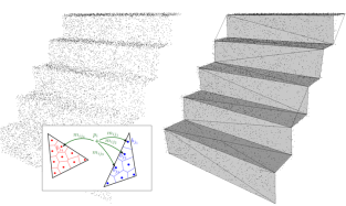
Conference papers
- titre
- Changements d’apparences au cours des saisons
- auteur
- François Grosbellet, Adrien Peytavie, Eric Guérin, Eric Galin, Stéphane Mérillou, Bedrich Benes
- Accès au bibtex
-
- titre
- Changement d’apparence au cours des saisons
- auteur
- François Grosbellet, Adrien Peytavie, Eric Guérin, Eric Galin, Stéphane Mérillou, Bedrich Benes
- resume
- Dans cet article, nous proposons un framework procédural permettant de modifier automatiquement l'apparence de grandes scènes en fonction des saisons. Ce framework est basé sur deux types de composants qui communiquent entre eux. En premier lieu les objets environnementaux, qui en réagissant à leur environnement, génèrent leurs variations d'apparence (couche de neige, de glace, de feuilles). L'environnement, qui décrit spatialement et quantitativement les différents phénomènes, est modélisé par un ensemble de champs d'influence. Cette approche offre une grand liberté de contrôle aux utilisateurs, permet un calcul rapide des différents phénomènes, et autorise la création de grandes scènes dont la surface est environ cent fois supérieur à celle des scènes produites par les méthodes existantes.
- Accès au bibtex
-
- titre
- Construction of a unique robust hamiltonian path for a vertex cloud
- auteur
- Vincent Itier, William Puech, Jean-Pierre Pedeboy, Gilles Gesquière
- resume
- Efficient data synchronization for 3D mesh models is a new major challenge. 3D models are also now being used to an increasing extent and with current network technology, 3D model compression, visualization and protection demand increases. However, there is still no perfect method to achieve this data synchronization while being blind and robust against various attacks. We propose a blind method based on a Hamiltonian path to synchronize vertex clouds, and particularly on 3D meshes. We experimentally show that it is fast and robust against Gaussian noise. This novel approach can generate better results than meshbased methods because it does not use vertex connectivity.
- Accès au bibtex
-
-
- titre
- Identifying Perceptually Salient Features on 2D Shapes
- auteur
- Lisa Larsson, Géraldine Morin, Antoine Begault, Raphaëlle Chaine, Jeannine Abiva, Evelyne Hubert, Monica Hurdal, Mao Li, Beatriz Paniagua, Giang Tran, Marie-Paule Cani
- resume
- Maintaining the local style and scale of 2D shape features during deformation, such as when elongating, compressing, or bending a shape, is essential for interactive shape editing. To achieve this, a necessary first step is to develop a robust classification method able to detect salient shape features, if possible in a hierarchical manner. Our aim is to overcome the limitations of existing techniques, which are not always able to detect what a user immediately identifies as a shape feature. Therefore, we first conduct a user study enabling us to learn how shape features are perceived. We then propose and compare several algorithms, all based on the medial axis transform or similar skeletal representations, to identify relevant shape features from this perceptual viewpoint. We discuss the results of each algorithm and compare them with those of the user study, leading to a practical solution for computing hierarchies of salient features on 2D shapes.
- Accès au texte intégral et bibtex
-

- titre
- Détermination d'une séquence de bascules d'arêtes entre deux triangulations de même genre topologique
- auteur
- J. Espinas, Raphaëlle Chaine, P.-M. Gandoin
- resume
- Etant données deux triangulations connexes T1 et T2 de même genre topologique et contenant un même nombre de sommets, nous présentons un algorithme direct et efficace permettant de changer la connectivité de T1 (c'est-à-dire le graphe sous-jacent) en celle de T2 en utilisant une unique opération, la bascule d'arête, et sans avoir à connaître le genre topologique commun à T1 et T2. Nous utilisons également une correspondance entre les sommets des deux maillages, qui, si elle est non fournie, peut être choisie de manière totalement aléatoire.
- Accès au bibtex
-
- titre
- The surface nanostructurations by means of near field enhancement with nanospheres
- auteur
- Ph Delaporte, D. Grojo, L. Boarino, L. Charmasson, N. de Leo, K. L. N. Deepak, M. Laus, G. Panzarasa, A. Pereira, R. Rocci, K. Sparnacci, O. Uteza
- resume
- Laser-matter interaction is a unique and simple approach to structure materials or locally modify their properties at the micro and nanoscale level. Playing with the pulse duration and the laser wavelength, a broad range of materials and applications can be addressed. Direct irradiation of surfaces with laser beam through a standard optical beam setup allows an easy and fast structuring of these surfaces in the range of few micrometers. However, the irradiation of materials through an array of dielectric nanospheres provides a unique opportunity to break the diffraction limit and to realize structures in the range of hundred of nanometers. This simple, fast and low-cost near-field nanolithography technique is presented and discussed, as well as its great potential. The theoretical aspects of the near-field enhancement effects underneath the particles have been studied with a simple model based on the Mie theory. A commercial FDTD software has also been used to study the influence of the substrate and the surrounding media, on the energy profile of the photonic jet generated under the sphere. A specific study has been dedicated to the influence of the dispersion of the sphere diameter on the morphology of the ablation craters. This technique has been used for patterning bi-layer substrates. The process leads to the formation of a nanoporous membrane which has been used to realize an array of gold nanodots on silicon. We have also associated the Laser-Induced Forward Transfer (LIFT) process with the near-field nanolithography to print, in a single laser shot, an array of metallic nanobumps.
- Accès au bibtex
-
- titre
- Transport optimal pour la reconstruction robuste de formes à partir de nuages de points
- auteur
- Julie Digne, Pierre Alliez, David Cohen-Steiner
- resume
- Notre approche consiste à considérer le nuage de points en entrée comme une mesure discrète (une distribution de masses), et à construire une approximation par une mesure continue (et constante par morceaux)sur les faces d’un complexe simplicial. La distance entre les deux mesures est calculée par une approximation du transport optimal obtenue par programmation linéaire, et le complexe simplicial est obtenu par décimation et optimisation d’une triangulation de Delaunay initialisée avec un sous-ensemble des points en entrée. La distance utilisée est robuste à la fois au bruit et aux données aberrantes, et préserve les arêtes vives et les bords des formes à reconstruire. Cette distance peut également servir comme outil de post-traitement sur des surfaces lisses reconstruites avec des méthodes par fonction implicite.
- Accès au bibtex
-
Poster communications
- titre
- Modélisation procédurale de changements de saison
- auteur
- François Grosbellet, Stéphane Mérillou, Eric Galin, Eric Guérin, Adrien Peytavie, Bedrich Benes
- resume
- Dans cet article, nous proposons un framework procédural permettant de modifier automatiquement l'apparence de grandes scènes en fonction des saisons. Ce framework est basé sur deux types de composants qui communiquent entre eux. En premier lieu les objets environnementaux, qui en réagissant à leur environnement, génèrent leurs variations d'apparence (couche de neige, de glace, de feuilles). L'environnement, qui décrit spatialement et quantitativement les différents phénomènes, est modélisé par un ensemble de champs d'influence. Cette approche offre une grand liberté de contrôle aux utilisateurs, permet un calcul rapide des différents phénomènes, et autorise la création de grandes scènes dont la surface est environ cent fois supérieur à celle des scènes produites par les méthodes existantes.
- Accès au bibtex
-
Reports
-
- titre
- Practical Reduction of Edge Flip Sequences in Two-Dimensional Triangulations
- auteur
- Jérémy Espinas, Raphaëlle Chaine, Pierre-Marie Gandoin
- resume
- The development of laser scanning techniques has popularized the representation of 3D shapes by triangular meshes with a large number of vertices. Compression techniques dedicated to such meshes have emerged, which exploit the idea that the connectivity of a dense mesh does not deviate much from the connectivity that can be constructed automatically from the vertex positions (while possibly being guided by additional codes). The edge flip is one of the tools that can encode the differences between two meshes, and it is important to control the length of a sequence of flips that transform one triangulation into another. This paper provides a practical solution to this problem. Indeed, the problem of determining a minimal sequence of edge flips between two triangulations is NP-complete for some types of triangulations including manifold triangulations of surfaces, so that it is necessary to develop heuristics. Moreover, it is sometimes difficult to establish a first sequence of flips between two meshes, and we advocate a solution based on the reduction of an existing sequence. The new approach we propose is founded on the assignment of labels to identify the edges, with a property of label transfer during a flip. This gives a meaning to the tracking of an edge in a sequence of flips and offers the exploitation of very simple combinatorial properties. All the operations are performed directly on the sequence of labels denoting the edges to be flipped, almost regardless of the underlying surface, since only local temporary connectivity is involved.
- Accès au texte intégral et bibtex
-

Preprints, Working Papers, ...
- titre
- Structures quasi-uniformes pour la sculpture interactive
- auteur
- Lucian Stanculescu
- resume
- Les outils de sculpture virtuelle aux applications dans l'industrie du cinéma et des jeux vidéo deviennent de plus en plus simples à utiliser. Cependant, les artistes ont toujours besoin de connaitre certaines caractéristiques des modèles sous-jacents et des techniques de sculpture spécifiques a chaque modèle. Afin de rendre l'utilisation plus intuitive, nous proposons un nouveau modèle, simple, basé sur un maillage quasi-uniforme, permettant de sculpter librement des objets 3D avec une évolution automatique de la topologie. Nous introduisons ensuite un cadre général où des structures multidimensionnelles (volumes, surfaces, courbes, points) se combinent hiérarchiquement, dans le but de permettre la création d'objets qui combinent formes libres et CAO. Nous montrons des exemples réalisés avec une application de sculpture développée pendant la thèse
- Accès au bibtex
-
2012
Journal articles
- titre
- 3D Visualization of Urban Data Based on CityGML with WebGL
- auteur
- Gilles Gesquière, Alexis Manin
- resume
- Due to the advances in computer graphics and improved network speed it is now possible to navigate in 3D virtual world in real time. Until now, technologies employed require to install standalone application or plugins on navigators. The arrival of HTML 5 brings news solutions to visualize 3D data in a browser with WebGL. Several globe projects have proven that such technologies can be employed. Unfortunately, demonstrations are often based on proprietary formats to exchange or to store data. In this work, we propose to use CityGML: a standard provided by the Open Geospatial Consortium. CityGML files are imported in our Environment Editor. With several tools that we present in this paper, data are processed and stored. A client server application is also presented to permit the visualization of geometry and semantic in a navigator
- Accès au bibtex
-
-
- titre
- Procedural Generation of Villages on Arbitrary Terrains
- auteur
- Arnaud Emilien, Adrien Bernhardt, Adrien Peytavie, Marie-Paule Cani, Eric Galin
- resume
- Although procedural modeling of cities has attracted a lot of attention for the past decade, populating arbitrary landscapes with non-urban settlements remains an open problem. In this work, we focus on the modeling of small, European villages that took benefit of terrain features to settle in safe, sunny or simply convenient places. We introduce a three step procedural generation method. First, an iterative process based on interest maps is used to progressively generate settlement seeds and the roads that connect them. The fact that a new road attracts settlers while a new house often leads to some extension of the road network is taken into account. Then, an anisotropic conquest method is introduced to segment the land into parcels around settlement seeds. Finally, we introduce open shape grammar to generate 3D geometry that adapts to the local slope. We demonstrate the effectiveness of our method by generating different kinds of villages on arbitrary terrains, from a mountain hamlet to a fisherman village, and validate through comparison with real data.
- Accès au texte intégral et bibtex
-
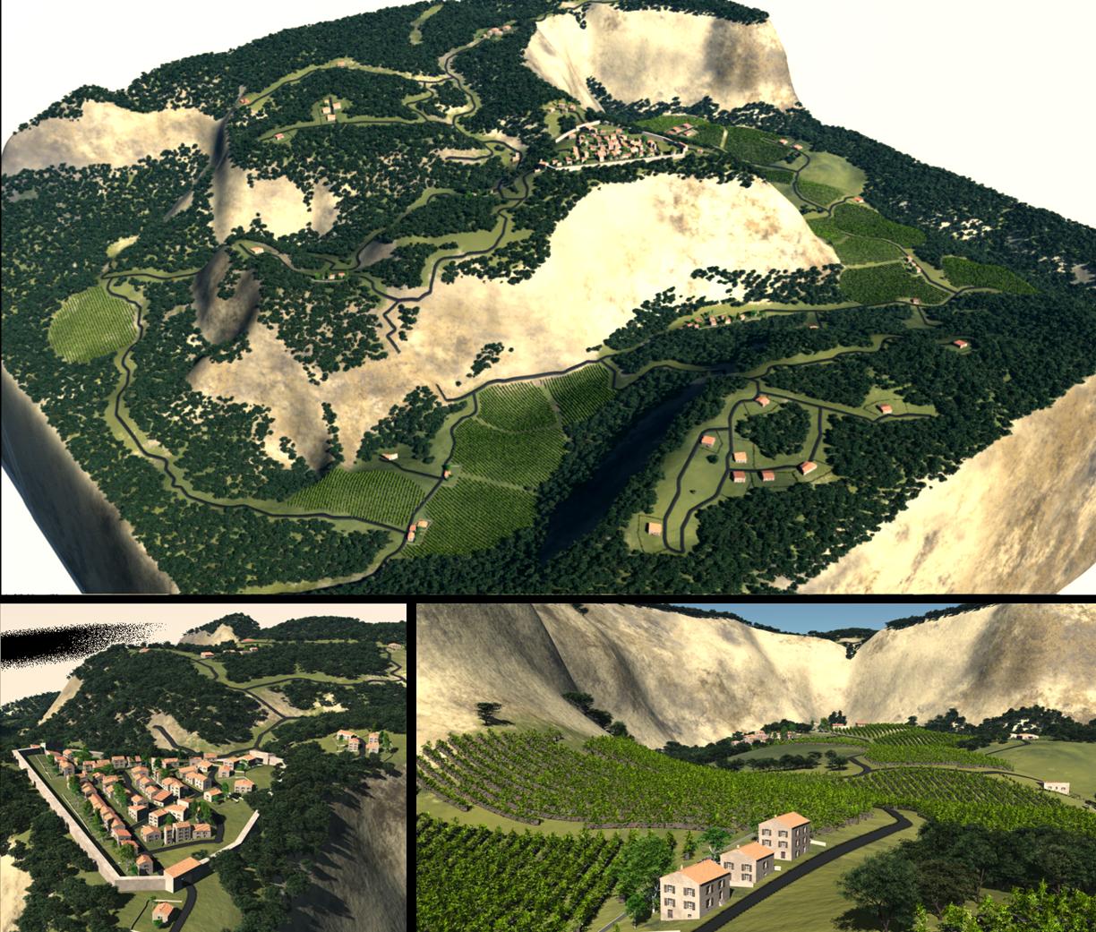
- titre
- Reconstruction of small solar system bodies using photoclinometry by deformation
- auteur
- Claire Capanna, Philippe Lamy, Laurent Jorda, Gilles Gesquière
- resume
- This article tackles the problem of reconstructing the 3D shape model of asteroids and cometary nuclei from images obtained with a visible imaging system aboard a planetary spacecraft. We describe a photoclinometry method based on the optimization of the chi-square difference between observed and synthetic images of the object by deformations of its initial shape, described here as a mesh of triangular facets. The non-linear optimization is performed using the so-called “limited-memory Broyden-Fletcher-Golbfarb-Shanno” algorithm. The deformations can be applied: (i) by modifying the coefficients of a spherical harmonics expansion in order to extract the global shape of the object, and/or (ii) by moving the height of the vertices of a triangular mesh in order to increase the accuracy of the global shape model and/or to derive local topographic maps of the surface. This method has been tested on images of the asteroids Steins and Lutetia obtained by the imaging system aboard the Rosetta spacecraft of the European Space Agency.
- Accès au bibtex
-
- titre
- La modélisation de la ville : Interopérabilité et intégration des données et modèles urbains : standards, normes et tendances
- auteur
- Emmanuel Devys, Gilles Gesquière
- resume
- La convergence des besoins relatifs à la modélisation urbaine entre les besoins utilisateurs d’une part, et ceux de l’ingénierie, de la maîtrise d’ouvrage et de la maîtrise d’oeuvre, ainsi que du monde de la recherche, est un gage de succès de projets urbains durables et pérennes. Ce besoin de convergence conduit en particulier à traiter de manière adaptée la problématique d’interopérabilité et d’intégration des données et modèles urbains. Cet état de l’art a pour objectif de donner un aperçu des standards et normes utilisables pour de tels modèles urbains (2D et 3D), notamment à l’ISO, l’Open Geospatial Consortium (OGC) et au Web3D Consortium, des tendances et initiatives en cours, notamment dans le cadre d’INSPIRE. Il illustrera également l’intérêt et la mise en oeuvre d’un standard tel que CityGML pour les diverses thématiques envisagées pour les modèles urbains, et quelques problématiques d’intérêt, comme par exemple l’aspect multi-échelles, la gestion de la sémantique, l’intégration de données terrain et l’imagerie. Un exemple simple extrait de la problématique de la mise à disposition de modèles numériques urbains pour la réalisation de simulation de phénomènes physiques sera ensuite abordé. L’objectif est de montrer que le partage d’un modèle et le fait de s'appuyer sur des échanges standardisés permet de faciliter les interactions entre les modèles physiques, et ainsi de coupler plusieurs modèles entre eux.
- Accès au bibtex
-
- titre
- Simulating How Salt Decay Ages Buildings
- auteur
- Nicolas Mérillou, Stéphane Mérillou, Eric Galin, Djamchid Ghazanfarpour
- resume
- Salt-based aging plays an important part in the realism of scenes featuring stone structures and monuments. A proposed model, based on physical behaviors and principles, replaces the simulation of complex physical formulations with ad hoc algorithms. It leads to plausible results, ultimately helping designers create aging patterns on affected objects.
- Accès au bibtex
-
Conference papers
- titre
- Génération procédurale de rivières et de terrains
- auteur
- Jean-David Genevaux, Eric Galin, Eric Guérin, Adrien Peytavie, Bedrich Benes
- resume
- Dans cet article, nous proposons une méthode de génération procédurale de terrains dont la structure satisfait les contraintes d’écoulement hydrographique. Étant donné un contour initial fourni par l’utilisateur, notre algorithme crée un réseau hiérarchique de cours d’eau à l’aide d’une grammaire ouverte. Ce réseau est ensuite analysé et enrichi par d’autres données vectorielles afin de décrire de façon plus précise les paramètres de trajectoire et le profil de chacun des cours d’eau. Nous construisons enfin le relief du terrain en respectant les contraintes d’écoulement d’eau dérivant du réseau. Notre approche offre l’utilisateur un contrôle à toutes les étapes du processus. Sans simulation physique, nous parvenons à obtenir des terrains détaillés et structurés à grande échelle.
- Accès au bibtex
-
- titre
- Simplification and Streaming of GIS Terrain for Web Clients
- auteur
- Fabien Cellier, Pierre-Marie Gandoin, Raphaëlle Chaine, Aurélien Barbier Accary, Samir Akkouche
- resume
- The application needs in 3D visualization culminate today, in particular in the field of geographic information systems (GIS), as evidenced by the popularity of applications like Google Earth or Google Map. Meanwhile, the popular success of mobile devices like smartphones or tablets and the explosion of cloud computing directly related to ubiquitous networks accelerates the gradual shift from the traditional desktop application development to web and specialized mobile application development. But if the latest technologies centered around HTML5 facilitate the development of rich internet applications (RIA), the gap in resources between a desktop computer and a smartphone requires still an important conceptual and algorithmic work when one aims to design web applications offering a user experience similar to desktop applications. In this paper, we propose a method of terrain simplification suitable for data compression and streaming, and therefore ideal for the GIS visualization in a web browser. Based on new parallel algorithms, this method was designed to exploit the multi-core architectures of the latest CPU and GPU, within the constraints of the latest HTML5 API (WebGL, WebSockets, WebCL). It offers the main advantage of working on irregular grids, which allows to modelize highly nonuniform terrains (containing for instance roads and buildings) that may be unprojectable (plain 3D and not only 2.5D).
- Accès au bibtex
-
- titre
- Effective Shapes Generation for Bayesian CAD Model Reconstruction
- auteur
- A. Bey, Raphaëlle Chaine, R. Marc, G. Thibault
- resume
- We address the reconstruction of CAD models from 3D point clouds, assuming that an a priori CAD model, roughly similar to the scene to reconstruct, is given. The problem can be solved using a Bayesian approach which states the reconstruction task as the search of the most probable CAD model. This article presents a reliable cylinder generation algorithm that can be used to efficiently reach the configuration which maximizes the target probability, combined with an efficient specific optimization heuristic. Results illustrate how our approach can automatically reconstruct CAD models of industrials scenes.
- Accès au bibtex
-
- titre
- Event and scenario recognition in a video surveillance system for radiotherapy treatments
- auteur
- M. Portela Sotelo, Pascal Dupuis, A. Pereira, E. Desserée, J.-M. Moreau, C. Ginestet, H. Kafrouni
- resume
- Purpose/Objective: We propose a module to monitor a treatment room using video cameras in order to assist and reassure the radiation therapist and to record the sequence of events during the treatment delivery process. This module will complement other existing quality assurance systems by adding external information on the patient and the elements surrounding him or her (people and objects). Such information is today rarely taken into account and may be acquired by means of a global viewing scheme. This system may be used to help minimize errors such as patient's identity, detection of involuntary movements, positioning relatively to a unique referential, presence of treatment accessorizes (bolus, ..) and presence of staff or undesired elements during irradiation, etc.
- Accès au bibtex
-
- titre
- E-learning with Quenlig: an online questionnaire
- auteur
- Yves Caniou, Thierry Excoffier
- resume
- Quenlig is a web application where users answer textually, generic to any kind of questionnaires, and designed as a formative assessment tool. Students can learn their courses, test their knowledge, exercise themselves and get ranked. It allows teachers to automatize examinations and practice lessons (giving context dependent advice when needed), dynamically monitor students progression and transparently verify if they cheat. The system returns statistics to improve the course quality and ensure a good knowledge acquisition. Examinations analysis show that its use in a low variance text based answer context improves knowledge acquisition.
- Accès au bibtex
-
-
- titre
- Reconstruction d'un nuage de points 3D étant donné un modèle CAO a priori
- auteur
- Aurélien Bey, Raphaëlle Chaine, Raphaël Marc, Guillaume Thibault
- resume
- Nous abordons dans cet article le problème de la reconstruction de modèles CAO à partir de nuages de points acquis en environnement industriel, en nous appuyant sur des modèles 3D préexistants ainsi que sur des connaissances métier quant à la composition des environnements traités. Ces diverses connaissances a priori peuvent être utilisées pour guider la reconstruction afin d'obtenir des modèles CAO fiables correspondant aux nuage de points. Nous concentrons plus particulièrement notre travail sur le traitement des parties cylindriques. Nous proposons de formuler le problème de la reconstruction comme la recherche de la configuration la plus probable vis-à-vis de multiples contraintes. Le problème d'optimisation ainsi défini est résolu à l'aide d'une méthode d'exploration stochastique de l'espace des solutions, basée sur l'ajout d'éléments dans la configuration en cours de construction et la gestion gloutonne des conflits pouvant survenir, de manière à améliorer efficacement la configuration à chaque étape. Nous montrons que la méthode proposée permet la reconstruction de modèles fiables en présentant quelques résultats obtenus sur une scène industrielle
- Accès au texte intégral et bibtex
-

Books
- titre
- VRIPHYS 2012: Ninth Workshop on Virtual Reality Interactions and Physical Simulations
- auteur
- Jan Bender, Arjan Kuijper, Dieter Fellner, Eric Guérin
- resume
- The workshop on Virtual Reality Interactions and Physical Simulations (VRIPHYS) is one of the well established international conferences in the field of computer animation and virtual reality. Since 2004, this annual workshop has provided an opportunity for researchers in computer animation and virtual reality to present and discuss their latest results, and to share ideas for potential directions of future research. The first workshop was held in Colima, Mexico, followed by successful workshops in Pisa, Italy,Madrid, Spain, Dublin, Ireland, Grenoble, France, Karlsruhe, Germany, Copenhagen, Denmark and Lyon, France. This year, the 9th VRIPHYS workshop is hosted by the Graduate School of Computational Engineering and the Interactive Graphics Systems Group at the Technical University of Darmstadt as well as Fraunhofer IGD. VRIPHYS is organized in collaboration with Eurographics (EG). The two-day workshop will take place on December 6 - 7, with a technical program consisting of 17 accepted full papers. All submitted papers have been reviewed by members of the International Program Committee (IPC). The technical program is supplemented by two invited speakers.We are very pleased that Jan Peters and Stéphane Cotin have agreed to give a presentation at the VRIPHYS workshop. Jan Peters is a full professor for Intelligent Autonomous Systems at the TU Darmstadt and Stéphane Cotin is the scientific leader of the SHACRA team at Inria Lille. The submission review management system (SRM) was provided by EG. The workshop proceedings are published by EG. The organizing committee would like to acknowledge the help of Stefanie Behnke: her support in organizing the submission and review process, and in compiling the proceedings was greatly appreciated.We also thank NVIDIA for sponsoring the Best Paper Award.We wish to say thanks to all members of the organizing committee for their involvement and continued support. Last, but not least, we would like to thank all members of the IPC, all additional reviewers, the invited speaker, the participants and all who have supported this year’s VRIPHYS workshop.
- Accès au bibtex
-
Poster communications
- titre
- Thickness Diagram for Shape Analysis
- auteur
- David Coeurjolly, Nina Amenta, Raphaëlle Chaine
- resume
- When performing geometrical analysis of shapes, the thickness of the shape at a point is a fundamental quantity both for theoretical and practical purposes. In this paper, we consider a thickness definition which associates a value with each point of the shape (i.e. both on its boundary and interior). If we now consider a discrete shape characterized by a sampling of a continuous shape boundary, such thickness function on interior points induces a combinatorial structure which can be used to efficiently compute some relevant quantities for shape description. The aim of the paper is thus to introduce and analyse the combinatorial structure, and to provide some convergence results when the sampling gets denser since the thickness function is deeply linked to the medial axis of the shape.
- Accès au bibtex
-
Reports
-
- titre
- A simple yet efficient algorithm to turn one oriented triangular mesh connectivity into another
- auteur
- Jérémy Espinas, Raphaëlle Chaine, Pierre-Marie Gandoin
- resume
- This paper addresses the problem of efficiently turning the connectivity of an initial triangular mesh into a new one, using combinatorial edge flip operations only, excluding vertex insertion and deletion. More precisely, we provide a practical but provably good solution for determining a sequence of edge flips between two surface triangulations sharing the same topological genus and the same number of vertices, with a one-to-one correspondence between the vertices of the two meshes. This is original in that the sequence of edge flips can be determined without using any canonical geometric or topological configuration, classically acting as a pivot between the two triangulations. The paper identifies the main difficulties that must be overcome by this direct algorithm, putting in place the foundation for a generic strategy. An efficient instantiation of this strategy is then presented, with an algorithm that proceeds by successive conformation of the facets, through a region-growing mechanism. The effectiveness of this approach is illustrated by practical benchmarks.
- Accès au texte intégral et bibtex
-

Theses
-
- titre
- Reconstruction of CAD model of industrial scenes using a priori knowledge
- auteur
- Aurélien Bey
- resume
- 3D models are often used in order to plan the maintenance of industrial environments.When it comes to the simulation of maintenance interventions, these 3D models have todescribe accurately the actual state of the scenes they stand for. These representationsare usually built from 3D point clouds that are huge set of 3D measurements acquiredin industrial sites, which guarantees the accuracy of the resulting 3D model. Althoughthere exists many works addressing the reconstruction problem, there is no solution toour knowledge which can provide results that are reliable enough to be further used inindustrial applications. Therefore this task is in fact handled by human experts nowadays.This thesis aims at providing a solution automating the reconstruction of industrialsites from 3D point clouds and providing highly reliable results. For that purpose, ourapproach relies on some available a priori knowledge and data about the scene to beprocessed. First, we consider that the 3D models of industrial sites are made of simpleprimitive shapes. Indeed, in the Computer Aided Design (CAD) field, this kind of scenesare described as assemblies of shapes such as planes, spheres, cylinders, cones, tori, . . . Ourown work focuses on planes, cylinders and tori since these three kind of shapes allow thedescription of most of the main components in industrial environment. Furthermore, weset some a priori rules about the way shapes should be assembled in a CAD model standingfor an industrial facility, which are based on expert knowledge about these environments.Eventually, we suppose that a CAD model standing for a scene which is similar to theone to be processed is available. This a priori CAO model typically comes from the priorreconstruction of a scene which looks like the one we are interested in. Despite the factthat they are similar theoretically, there may be significant differences between the sitessince each one has its own life cycle.Our work first states the reconstruction task as a Bayesian problem in which we haveto find the most probable CAD Model with respect to both the point cloud and the a prioriexpectations. In order to reach the CAD model maximizing the target probability, wepropose an iterative approach which improves the solution under construction each time anew randomly generated shape is tried to be inserted in it. Thus, the CAD model is builtstep by step by adding and removing shapes, until the algorithm gets to a local maximumof the target probability.
- Accès au texte intégral et bibtex
-

2011
Journal articles
-
- titre
- Authoring Hierarchical Road Networks
- auteur
- Eric Galin, Adrien Peytavie, Eric Guérin, Bedřich Beneš
- resume
- We present a procedural method for generating hierarchical road networks connecting cities, towns and villages over large terrains. Our approach relies on an original geometric graph generation algorithm based on a non-Euclidean metric combined with a path merging algorithm that creates junctions between the different types of roads. Unlike previous work, our method allows high level user control by manipulating the density and the pattern of the network. The geometry of the highways, primary and secondary roads as well as the interchanges and intersections are automatically created from the graph structure by instantiating generic parameterized models.
- Accès au texte intégral et bibtex
-

- titre
- Détection de cylindres dans les nuages de points de scènes industrielles basée sur l'utilisation de modèles 3D a priori
- auteur
- Aurélien Bey, Raphaëlle Chaine, Raphaël Marc, Guillaume Thibault
- resume
- Nous nous intéressons dans cet article au problème de la reconstruction de modèles 3D CAO à partir de nuages de points 3D issus d’acquisition laser en environnement industriel. Nous proposons pour cela d’utiliser des modèles 3D existants approximant les nuages de points. Ces modèles peuvent en effet être considérés comme des estimations initiales des scènes traitées, et constituent à ce titre une source de connaissance a priori importante. Nous nous intéressons ici plus particulièrement au traitement des cylindres. La solution que nous proposons permet de générer aléatoirement des ensembles de cylindres candidats potentiellement présents dans le nuage de points, et s’appuie pour cela sur l’information a priori. Le recours à l’a priori permet de diminuer la quantité de candidats non pertinents par rapport aux méthode stochastiques existantes (RANSAC), et de produire des cylindres plus fiables. Nous présentons notamment les résultats obtenus sur quelques jeux de données. Pour finir, nous discutons des possibilités d’intégration de cette solution dans une démarche plus globale visant à produire un modèle 3D consistant à partir des cylindres candidats ainsi générés.
- Accès au bibtex
-
-
- titre
- Freestyle: Sculpting meshes with self-adaptive topology
- auteur
- Lucian Stanculescu, Raphaëlle Chaine, Marie-Paule Cani
- resume
- We present a real-time method for sculpting triangular manifold meshes while enabling arbitrary surface deformation with seamless topological changes. Our insight is that the use of quasi-uniform mesh sampling, an interesting option now that very large meshes can be edited and displayed in real-time, provides the right framework for expressing and efficiently processing arbitrary changes of topological genus. The user controls deformation by gesture: he sweeps tools that apply a variety of deformation fields, from smoothing and trimming ones to local inflation and constant volume deformation tools. Meanwhile, the quasi-regular mesh seamlessly splits or locally blends when and where needed, while still following the user-specified deformation. Our method guarantees a closed, self-intersection-free mesh, whatever the user action. We demonstrate the practical usability of the resulting, interactive sculpting system through the sculpture of models that would have been extremely difficult to achieve with both current research methods and state of the art professional software.
- Accès au texte intégral et bibtex
-
Conference papers
- titre
- Generating Large-scale Details: Altering Soil Surface and Structure with Tracks
- auteur
- Alexandre Peyrat, Olivier Terraz, Stéphane Mérillou, Eric Galin, Djamchid Ghazanfarpour
- resume
- Tracks, footsteps and ruts are common elements we can observe in natural sceneries. Wherever there is human activity, we can find marks on the ground left by vehicles or walkers. These marks can be directly dug from a soft ground or left on a hard ground by objects that carry materials on their surfaces. This paper presents a method to alter soil with such tracks. These tracks are defined with a trajectory and the shape of the mark left by the moving object (vehicle or walker) and is then applied to the soil for each step of the trajectory. Using our method we can obtain tracks on a loose soil and the deposit of material through the track on the desired length. This method allows us to produce a great number of large-scale details on terrains.
- Accès au bibtex
-
- titre
- Consistent 3D Model Reconstruction From Point Cloud Data Using A Priori CAD Models
- auteur
- Aurélien Bey, Raphaëlle Chaine, Raphaël Marc, Guillaume Thibault, Samir Akkouche
- resume
- We address the reconstruction of 3D CAD models from point cloud data acquired in industrial environments, using a pre-existing 3D model as an initial estimate of the scene to be processed. Indeed, this prior knowledge can be used to drive the reconstruction so as to generate an accurate 3D model matching the point cloud. We more particularly focus our work on the cylindrical parts of the 3D models. We propose to state the problem in a probabilistic framework: we have to search for the 3D model which maximizes some probability taking several constraints into account, such as the relevancy with respect to the point cloud or the a priori 3D model, and the consistency of the reconstructed model. The resulting optimization problem can then be handled using a stochastic exploration of the solution space, based on the random insertion of elements in the configuration under construction, coupled with a greedy management of the conflicts. We present some results obtained on industrial data with the proposed approach.
- Accès au bibtex
-
- titre
- Ontology Development for the Integration of CAD Models in a Collaborative Environment
- auteur
- Samer Abdul Ghafour, Parisa Ghodous, Behzad Shariat Torbaghan, Eliane Perna
- resume
- A major issue in product development is the exchange and sharing of product knowledge among many actors. This knowledge includes many concepts such as design history, component structure, features, parameters, and more. Thus, to efficiently share design information, the design intent should be persistently captured and the semantics of the modeling terms should be processed both by design collaborators and intelligent systems. Our research investigates the use of Semantic Web technologies for the exchange of “intelligent” CAD models, while maintaining the original relations among entities of the model. Thus, we have proposed an ontological approach based on the construction of a common design features ontology, used as an Interlingua for the exchange of product data. This ontology is represented formally with OWL DL. The ontologies integration process relies basically on reasoning capabilities provided by description logics in order to recognize automatically additional mappings among ontologies entities.
- Accès au bibtex
-
Poster communications
- titre
- 3D Arrow: a Virtual Pointer for Immersive Sculpting
- auteur
- Jérôme Grosjean, Jérôme Simonin, Eric Galin, Stéphane Mérillou
- Accès au bibtex
-
Preprints, Working Papers, ...
- titre
- Triangulations pertinentes pour les formes 3D
- auteur
- Raphaëlle Chaine
- resume
- Confortée par la recrudescence et la variété des supports d’affichage numérique, l’utilisation des images comme vecteur de communication entraîne actuellement une demande croissante en termes de création de contenu virtuel tridimensionnel. Ce besoin de formes numériques 3D ne se limite pas à la création d’objets imaginaires, mais aussi à la production de maquettes virtuelles d’objets du monde réel. Il faut dire que les progrès des technologies d’acquisition 3D permettent désormais de numériser les objets avec du matériel de plus en plus léger et accessible, même pour les loisirs numériques. Cette activité n’est donc plus l’apanage de certaines industries très spécifiques comme le cinéma, le jeu vidéo ou le design industriel, mais touche de nombreux autres métiers : la culture avec les musées virtuels, le commerce électronique avec l’affichage des objets en 3D sur le web, l’architecture avec la simulation de construction ou de rénovation, etc. Face à ce phénomène, il devient de plus en plus important que la génération de contenu virtuel repose sur des modèles géométriques souples d’utilisation, sans sacrifier à leur validité et à leur qualité. Ce manuscrit expose des approches robustes et intuitives pour la modélisation de formes libres, à partir des données issues de la numérisation d’un objet réel ou bien créées à partir de rien, avec des gestes simples, par un artiste ou un amateur. Les formes 3D produites correspondent à des maillages triangulés de qualité, qui peuvent ensuite être visualisés, édités et manipulés avec facilité, grâce à l’introduction de flexibilité dans les traitements. L’adaptation de ces résultats à des contraintes matérielles de mémoire et de débit est également abordée, ainsi que les aspects compression et transmission progressive, en passant par l’intégration d’un aspect temporel. Cette approche de la modélisation géométrique s’inscrit dans un cadre de travail fondé sur l’exploitation des triangulations pertinentes pour la description des formes 3D échantillonnées. La pertinence d’une triangulation pourra dépendre de l’échantillonnage sur lequel elle s’appuie, ou bien sur sa concision et la qualité de ses triangles. Elle s’appuiera parfois aussi sur sa possibilité d’être générée de manière implicite et rapide ou encore sur sa capacité à évoluer dynamiquement. Dans tous les cas, les triangulations utilisées et exhibées seront traitées comme des propriétés sous-jacentes à la description de la forme, en faisant intervenir le moins de paramètres possibles, si ce n’est des paramètres physiquement significatifs ou intuitifs à l’utilisateur
- Accès au bibtex
-
2010
Journal articles
- titre
- Détection de cylindres dans les nuages de points de scènes industrielles basée sur l’utilisation de modèles 3D a priori
- auteur
- Aurélien Bey, Raphaëlle Chaine, Raphaël Marc, Guillaume Thibault
- resume
- Nous nous intéressons dans cet article au problème de la reconstruction de modèles 3D CAO à partir de nuages de points 3D issus d’acquisition laser en environnement industriel. Nous proposons pour cela d’utiliser des modèles 3D existants approximant les nuages de points. Ces modèles peuvent en effet être considérés comme des estimations initiales des scènes traitées, et constituent à ce titre une source de connaissance a priori importante. Nous nous intéressons ici plus particulièrement au traitement des cylindres. La solution que nous proposons permet de générer aléatoirement des ensembles de cylindres candidats potentiellement présents dans le nuage de points, et s’appuie pour cela sur l’information a priori. Le recours à l’a priori permet de diminuer la quantité de candidats non pertinents par rapport aux approches aléatoires existantes (RANSAC), et de produire des cylindres plus fiables. Nous présentons notamment les résultats obtenus sur quelques jeux de données. Pour finir, nous discutons des possibilités d’intégration de cette solution dans une approche plus globale visant à produire un modèle 3D consistant à partir des cylindres candidats ainsi produits.
- Accès au bibtex
-
-
- titre
- Multiresolution control of curves and surfaces with a self-similar model
- auteur
- Houssam Hnaidi, Eric Guérin, Samir Akkouche
- resume
- This paper presents two self-similar models that allow the control of curves and surfaces. The first model is based on IFS (Iterated Function Systems) theory and the second on subdivision curve and surface theory. Both of these methods employ the detail concept as in the wavelet transform and allow the multiresolution control of objects with control points at any resolution level. In the first model, the detail is inserted independently of control points, requiring it to be rotated when applying deformations. On the contrary, the second method describes details relative to control points, allowing free control point deformations. Modelling examples of curves and surfaces are presented, showing manipulation facilities of the models.
- Accès au texte intégral et bibtex
-

- titre
- Feature based terrain generation using diffusion equation
- auteur
- Houssam Hnaidi, Eric Guérin, Samir Akkouche, Adrien Peytavie, Eric Galin
- resume
- This paper presents a diffusion method for generating terrains from a set of parameterized curves that characterize the landform features such as ridge lines, riverbeds or cliffs. Our approach provides the user with an intuitive vector-based feature-oriented control over the terrain. Different types of constraints (such as elevation, slope angle and roughness) can be attached to the curves so as to define the shape of the terrain. The terrain is generated from the curve representation by using an efficient multigrid diffusion algorithm. The algorithm can be efficiently implemented on the GPU, which allows the user to interactively create a vast variety of landscapes.
- Accès au bibtex
-
-
- titre
- Procedural Generation of Roads
- auteur
- Nicolas Marechal, Eric Galin, Adrien Peytavie, N Maréchal, Eric Guérin
- resume
- In this paper, we propose an automatic method for generating roads based on a weighted anisotropic shortest path algorithm. Given an input scene, we automatically create a path connecting an initial and a final point. The trajectory of the road minimizes a cost function that takes into account the different parameters of the scene including the slope of the terrain, natural obstacles such as rivers, lakes, mountains and forests. The road is generated by excavating the terrain along the path and instantiating generic parameterized models.
- Accès au texte intégral et bibtex
-

- titre
- Heat Transfer Simulation for Modeling Realistic Winter Sceneries
- auteur
- Nicolas Maréchal, Eric Guérin, Eric Galin, Stéphane Mérillou, Nicolas Mérillou
- resume
- This paper presents a physically based method for simulating the heat transfers between the different environmental elements to synthesize realistic winter sceneries. We simulate the snow fall over the ground, as well as the conductive, convective and radiative thermal transfers using a finite volume method according to the variations of air and dew point temperatures, the amount of snow, cloud cover and day-night cycles. Our approach takes into account phase changes such as snow melting into water or water freezing into ice.
- Accès au bibtex
-
Conference papers
- titre
- Component-Based Model Synthesis for Low Polygonal Models
- auteur
- Nicolas Marechal, Eric Galin, Eric Guérin, Samir Akkouche
- resume
- This paper presents a method for semi-automatically generating a variety of different objects from an initial low polygonal model. Our approach aims at generating large sets of models with small variants with a view to avoiding instance replications which produce unrealistic repetitive patterns. The generation process consists in decomposing the initial object into a set of components. Their geometry and texture are edited and the modified components are then combined together to create a large set of varying models. Our method has been implemented in the Twilight 2 development framework of Eden Games and Widescreen Games and successfully experimented on different types of models.
- Accès au bibtex
-
Theses
-
- titre
- Procedural generation of world
- auteur
- Adrien Peytavie
- resume
- In this thesis, we address the problem of automatic generation of graphical content with a high level of detail for the generation of worlds. In this quest for realism, the major scientific and technical challenges include: managing the mass of geometric data needed to create varieties of natural objects, taking into account interactions with the various objects and user control.Our approach is based on an original volumetric model for representing and unifying the different materials of land. We offer a range of high-level algorithms, combining simulation steps to ensure physical plausibility and visual realism, and procedural generation techniques to effectively manage complexity. Our algorithms are used to sculpt and complex terrain with caves and overhangs and generate roads with tunnels and bridges to cross natural barriers.
- Accès au texte intégral et bibtex
-

-
- titre
- Graphical content generation
- auteur
- Nicolas Marechal
- resume
- The goal of this thesis is the search for new techniques for generating digital content for video game applications. The lack of variety of objects and details strongly affects the realism of synthetic landscapes. In this context, a major bottleneck is the creation of graphical assets to create the scenes. To simplify and accelerate this task, we present methods to automatically generate graphical content with a view to creating large, convincing and realistic landscapes.We present a first category of method to create and edit quickly a vast variety of objects from an initial model provided by a graphic designer, under the constraint of low polygonal modeling. We also present a procedural method for generating of varieties of objects. Together, these methods can create many varieties of natural forms as well as roads, bridges and tunnels that can automatically adapt to the landform features of an input terrain.We propose another method, based on a physical simulation and heat transfer simulation to create winter landscapes that evolve over time depending on the weather conditions. This approach allows us to follow the evolution of the snowpack and the thickness of the ice that forms on the surface of a lake.
- Accès au texte intégral et bibtex
-

Preprints, Working Papers, ...
- titre
- Control in the generation of natural forms
- auteur
- Houssam Hnaidi
- resume
- The generation of natural shapes has been the subject of much research for many years. Several methods have been proposed to generate realistic natural objects such as terrain, plants and trees, clouds, etc... Iterative models are well known in this field of research due to their ability to generate complex and rough shapes that are adapted to the representation of natural objects. The major drawback of such models is the lack of control over the final result. The latter can come from the stochastic construction method which prevents any control by definition. For models whose construction is deterministic, the parameters of generation are often non-intuitive and thus limit control. For these reasons many studieshave focused on the problem of controlling these models as well as the possibility of using non-iterative models (sketches, based on examples, etc). Often, control introduced by these models is a global control, on the whole final object and therefore does not include local details of this object. In our work, we focus in the problem of control over natural shapes, taking into account local control. To this end, we introduce two different models. The first is based on an iterative formalism with detail concept which is divided into two subfamilies, one based on IFS and the other one based on subdivisionsurfaces. The second model allows the editing of terrain features under a form of vectorial primitives which one used to generate the terrain by guided diffusion method. The latter is the subject of a parallel implementation on graphics card (GPU).
- Accès au bibtex
-
2009
Journal articles
- titre
- MIXED-ASPECT FRACTAL CURVES
- auteur
- Christian Gentil, Eric Tosan, Marc Neveu
- resume
- The aim of our work is to elaborate a method to build parametric shapes (curves, surfaces,\dots) with a non uniform local aspect : every point is assigned a ''geometric texture'' that evolves continuously from a smooth aspect to a rough aspect.\\ We rely on previous work that enables us to represent free form curves that are either smooth or fractal. We propose a formalism based on finite families of iterated function systems that generalizes this previous approach. The principle is to blend shapes with uniform aspects to define a shape with a variable aspect.
- Accès au bibtex
-
-
- titre
- CHuMI Viewer: Compressive Huge Mesh Interactive Viewer
- auteur
- Clément Jamin, Pierre-Marie Gandoin, Samir Akkouche
- resume
- The preprocessing of large meshes to provide and optimize interactive visualization implies a complete reorganization that often introduces significant data growth. This is detrimental to storage and network transmission, but in the near future could also affect the efficiency of the visualization process itself, because of the increasing gap between computing times and external access times. In this article, we attempt to reconcile lossless compression and visualization by proposing a data structure that radically reduces the size of the object while supporting a fast interactive navigation based on a viewing distance criterion. In addition to this double capability, this method works out-of-core and can handle meshes containing several hundred million vertices. Furthermore, it presents the advantage of dealing with any n-dimensional simplicial complex, including triangle soups or volumetric meshes, and provides a significant rate-distortion improvement. The performance attained is near state-of-the-art in terms of the compression ratio as well as the visualization frame rates, offering a unique combination that can be useful in numerous applications.
- Accès au texte intégral et bibtex
-

-
- titre
- Reconstruction Algorithms as a Suitable Basis for Mesh Connectivity Compression
- auteur
- Raphaëlle Chaine, Pierre-Marie Gandoin, Céline Roudet
- resume
- During a highly productive period running from 1995 to about 2002, the research in lossless compression of surface meshes mainly consisted in a hard battle for the best bitrates. But for a few years, compression rates seem stabilized around 1.5 bit per vertex for the connectivity coding of usual triangular meshes, and more and more work is dedicated to remeshing, lossy compression, or gigantic mesh compression, where memory access and CPU optimizations are the new priority. However, the size of 3D models keeps growing, and many application fields keep requiring lossless compression. In this paper, we present a new contribution for single-rate lossless connectivity compression, which first brings improvement over current state of the art bitrates, and secondly, does not constraint the coding of the vertex positions, offering therefore a good complementarity with the best performing geometric compression methods. The initial observation having motivated this work is that very often, most of the connectivity part of a mesh can be automatically deduced from its geometric part using reconstruction algorithms. This has already been used within the limited framework of projectable objects (essentially terrain models and GIS), but finds here its first generalization to arbitrary triangular meshes, without any limitation regarding the topological genus, the number of connected components, the manifoldness or the regularity. This can be obtained by constraining and guiding a Delaunay-based reconstruction algorithm so that it outputs the initial mesh to be coded. The resulting rates seem extremely competitive when the meshes are fully included in Delaunay, and are still good compared to the state of the art in the case of scanned models.
- Accès au texte intégral et bibtex
-

-
- titre
- Progressive Lossless Mesh Compression Via Incremental Parametric Refinement
- auteur
- Sébastien Valette, Raphaëlle Chaine, Rémy Prost
- resume
- In this paper, we propose a novel progressive lossless mesh compression algorithm based on Incremental Parametric Refinement, where the connectivity is uncontrolled in a first step, yielding visually pleasing meshes at each resolution level while saving connectivity information compared to previous approaches. The algorithm starts with a coarse version of the original mesh, which is further refined by means of a novel refinement scheme. The mesh refinement is driven by a geometric criterion, in spirit with surface reconstruction algorithms, aiming at generating uniform meshes. The vertices coordinates are also quantized and transmitted in a progressive way, following a geometric criterion, efficiently allocating the bit budget. With this assumption, the generated intermediate meshes tend to exhibit a uniform sampling. The potential discrepancy between the resulting connectivity and the original one is corrected at the end of the algorithm. We provide a proof-of-concept implementation, yielding very competitive results compared to previous works in terms of rate/distortion trade-off.
- Accès au texte intégral et bibtex
-

- titre
- Un modèle itératif de surfaces pour la construction en bois
- auteur
- Gilles Gouaty, Eric Tosan, Ivo Stotz, Yves Weinand
- resume
- Dans le cadre de la construction en bois, nous nous intéressons à la modélisation de maillages surfaciques 3D basés sur un modèle itératif inspiré du modèle IFS (Iterated Function System). Les formes modélisées doivent satisfaire certaines propriétés afin d’assurer leur constructibilité physique. Nous nous intéressons ici aux contraintes géométriques de planéité des faces d’un maillage quadrangulaire, permettant la construction d’assemblages de panneaux de bois découpés. Nous décrivons dans un premier temps un modèle permettant de représenter certains types de maillages à faces planes. Ce modèle est défini comme une certaine somme de deux courbes. Nous présentons ensuite quelques propriétés élémentaires du modèle itératif que nous utilisons, inspiré du modèle IFS. Nous définissons enfin un modèle de surfaces générées par un opérateur de combinaison entre deux IFS décrivant chacun une certaine courbe. Nous montrons qu’il peut également être considéré comme un carreau à pôles généré par un produit d’IFS.
- Accès au bibtex
-
- titre
- Compression out-of-core pour la visualisation interactive de maillages volumineux
- auteur
- Clément Jamin, Pierre-Marie Gandoin, Samir Akkouche
- resume
- Le prétraitement des maillages à des fins de visualisation interactive implique une réorganisation complète des données qui induit souvent une augmentation significative de la taille des fichiers. Cela nuit non seulement au stockage et à la transmission réseau, mais pourrait aussi, dans un futur proche, affecter l'efficacité de la visualisation elle-même, au vu de l'écart croissant entre la vitesse des processeurs et la lenteur relative des mémoires externes. Dans cet article, nous tentons de réconcilier compression sans perte et visualisation, grâce à une structure de donnée qui réduit la taille des objets tout en permettant une navigation interactive. En supplément de cette double capacité, cette méthode est out-of-core et peut ainsi traiter des maillages de plusieurs centaines de millions de triangles. En outre, tout complexe simplicial de dimension n est accepté en entrée, que ce soit une soupe de triangles ou un maillage volumétrique, et la compression distribue les données de façon à optimiser le ratio débit-distorsion. Les performances sont proches de l'état de l'art, aussi bien en terme de taux de compression qu'en terme de vitesse d'affichage, ce qui offre un compromis utile à de nombreuses applications.
- Accès au bibtex
-
-
- titre
- Procedural Generation of Rock Piles Using Aperiodic Tiling
- auteur
- Adrien Peytavie, Eric Galin, Jérôme Grosjean, Stéphane Mérillou
- resume
- In this paper, we present a tiling method for generating piles of rocks without any computationally demanding physically-based simulation. Previous techniques rely on a periodic tiling of rocks and generate unrealistic repetitive patterns. In contrast, our approach relies on a modified corner cube algorithm to generate a set of aperiodic tiles. We generalize the construction method so that the geometry of rocks should straddle corner cubes with a view to avoiding unrealistic gaps in the arrangement of rocks. Moreover, we propose an original technique to control the shape of rocks into contact by computing the Voronoï cells using a parameterized anisotropic distance. Our method has been successfully used to generate landscapes and stone huts and walls with thousands of rocks piled together.
- Accès au texte intégral et bibtex
-

-
- titre
- Arches : a Framework for Modelling Complex Terrains
- auteur
- Adrien Peytavie, Eric Galin, Jérôme Grosjean, Stéphane Mérillou
- resume
- In this paper, we present a framework for representing complex terrains with such features as overhangs, arches and caves and including different materials such as sand and rocks. Our hybrid model combines a volumetric discrete data structure that stores the different materials and an implicit representation for sculpting and reconstructing the surface of the terrain. Complex scenes can be edited and sculpted interactively with high level tools. We also propose an original rock generation technique that enables us to automatically generate complex rocky sceneries with piles of rocks without any computationally demanding physically-based simulation.
- Accès au texte intégral et bibtex
-

Conference papers
- titre
- Génération procédurale de routes
- auteur
- Adrien Peytavie, Nicolas Marechal, Eric Guérin, Eric Galin
- resume
- Dans cet article, nous proposons une méthode de génération procédurale de routes à l’aide d’un algorithme de plus court chemin anisotrope. La trajectoire de la route minimise une fonction de coût prenant en compte les différents paramètres géométriques de la scène comme la pente du terrain et les obstacles naturels comme les rivières, les lacs, les montagnes et les forêts. Notre méthode permet de détecter et de générer des tunnels et des ponts lorsque cela est nécessaire. Le modèle final est obtenu en creusant le terrain le long de la trajectoire et par instanciation de modèles génériques paramétrés.
- Accès au bibtex
-
- titre
- Simulating Atmospheric Pollution Weathering on Buildings
- auteur
- Nicolas Mérillou, Stéphane Mérillou, Djamchid Ghazanfarpour, Jean-Michel Dischler, Eric Galin
- Accès au bibtex
-
Preprints, Working Papers, ...
- titre
- Algorithms and compact data structures for interactive visualization of gigantic 3D objects
- auteur
- Clément Jamin
- resume
- Progressive compression methods are now mature (obtained rates are close to theoretical bounds) and interactive visualization of huge meshes has been a reality for a few years. However, even if the combination of compression and visualization is often mentioned as a perspective, very few papers deal with this problem, and the files created by visualization algorithms are often much larger than the original ones. In fact, compression favors a low file size to the detriment of a fast data access, whereas visualization methods focus on rendering speed : both goals are opposing and competing. Starting from an existing progressive compression method incompatible with selective and interactive refinements and usable on small-sized meshes only, this thesis tries to reconcile lossless compression and visualization by proposing new algorithms and data structures which radically reduce the size of the objects while supporting a fast interactive navigation. In addition to this double capability, our method works out-of-core and can handle meshes containing several hundreds of millions vertices. Furthermore, it presents the advantage of dealing with any n-dimensional simplicial complex, which includes triangle soups or volumetric meshes.
- Accès au bibtex
-
2008
Journal articles
- titre
- A theoretical framework mapping Grammar based systems and Fractal description
- auteur
- Ikbal Zammouri, Eric Tosan, Béchir Ayeb
- resume
- In this work, we propose a new method to describe fractal shapes using parametric L-systems. This method consists of introducing scaling factors in the production rules of the parametric L-system grammars. We present a turtle monoid on which we base our calculations to show the exact mathematical relation between L-systems and iterated function systems (IFS); we then establish the conditions for the scaling factors to produce plants' and curves' fractal shapes from parametric L-systems. We demonstrate that with specific values of the scaling factors, we find the exact relationship established by Prusinkiewicz and Hammel between L-systems and IFS. Finaly, we present some examples of fractal plant forms ans curves created using parametric L-systems with scaling factors.
- Accès au bibtex
-
- titre
- Toward an efficient triangle-based spherical harmonics representation of 3D objects
- auteur
- Mohamed Mousa, Raphaëlle Chaine, Samir Akkouche, Eric Galin
- resume
- Version étendue et améliorée de l'article publié à Pacific Graphics l'année précédente
- Accès au bibtex
-
- titre
- Generating Vast Varieties of Realistic Leaves with Parametric 2Gmaps L-Systems
- auteur
- Alexandre Peyrat, Olivier Terraz, Stephane Merillou, Eric Galin
- resume
- Creating realistic plants and trees require the ability to generate thousands of leaves with different shapes and textures for different given species. This paper presents an original method to generate large atlases of leaves with many details from a single formal grammar. Leaves are described by a parameterized 2Gmap L-system that describes their evolution in shape and texture through out their entire life cycle. Our approach automatically synthesizes the deformations as well as the color and texture changes as the leaves age, as well as defects such as holes or cracks produced by insect attacks or accidents.
- Accès au bibtex
-
Conference papers
- titre
- Modélisation de terrains complexes 3D
- auteur
- Adrien Peytavie, Eric Galin, Stephane Merillou, Jérôme Grosjean
- resume
- Nous proposons un modèle hybride combinant une représentation discrète et une représentation implicite permettant de synthétiser des terrains complexes de topologie et de géométrie quelconque. Notre approche permet de représenter des surplombs, des grottes, des arches ainsi que les détails du sol tel que les pierres, la terre ou le sable. Des scènes complexes peuvent être éditées et sculptées interactivement avec des outils de haut niveaux. Nous proposons également une méthode de génération d’empilements de rochers.
- Accès au bibtex
-
- titre
- Génération de Variétés d'Objets par Fragments
- auteur
- Nicolas Marechal, Eric Galin, Eric Guérin, Samir Akkouche
- resume
- Cet article présente une méthode permettant de générer une grande variété d'objets de même nature à partir d'un modèle initial. Le processus de génération de variétés consiste à découper l'objet initial en fragments dont la géométrie et la texture sont modifiées avant d'être stockés dans un atlas. Les fragments contenus dans l'atlas sont alors recombinés par instanciation pour générer un très grand nombre de modèles différents pour un faible surcoût mémoire. Notre approche a été intégrée à la plateforme commune Twilight 2 des sociétés Eden Games et Widescreen Games et validée sur différents modèles.
- Accès au bibtex
-
- titre
- Compression out-of-core pour la visualisation interactive de maillages volumineux
- auteur
- Clément Jamin, Pierre-Marie Gandoin, Samir Akkouche
- resume
- Le prétraitement des maillages à des fins de visualisation interactive implique une réorganisation complète des données qui induit souvent une augmentation significative de la taille des fichiers. Cela nuit non seulement au stockage et à la transmission réseau, mais pourrait aussi, dans un futur proche, affecter l'efficacité de la visualisation elle-même, au vu de l'écart croissant entre la vitesse des processeurs et la lenteur relative des mémoires externes. Dans cet article, nous tentons de réconcilier compression sans perte et visualisation, grâce à une structure de donnée qui réduit la taille des objets tout en permettant une navigation interactive. En supplément de cette double capacité, cette méthode est out-of-core et peut ainsi traiter des maillages de plusieurs centaines de millions de triangles. En outre, tout complexe simplicial de dimension n est accepté en entrée, que ce soit une soupe de triangles ou un maillage volumétrique, et la compression distribue les données de façon à optimiser le ratio débit-distorsion. Les performances sont proches de l'état de l'art, aussi bien en terme de taux de compression qu'en terme de vitesse d'affichage, ce qui offre un compromis utile à de nombreuses applications.
- Accès au bibtex
-
- titre
- Towards an Intelligent CAD Models Sharing Based on Semantic Web Technologies
- auteur
- Samer Abdul Ghafour, Parisa Ghodous, B. Shariat, Eliane Perna
- resume
- Interoperability among CAD systems is a well known problem in collaborative product design and development. Nowadays, existing solutions and standards for product data integration are restricted to the process of geometrical data. As a result, the model can hardly be modified, and the original intent of the designer may be misunderstood. Hence, design intent such as design history, features, parameters and constraints should be consistently maintained while processing semantically modeling terms both by design collaborators and intelligent systems. In this paper, we investigate the use of Semantic Web technologies for the development of a common design features ontology, sharable for collaborative design. In our approach, we define the neutral format as an ontology using OWL (Web Ontology Language), and more specifically its sublanguage OWL DL based on descriptive logic, which is then enriched from the logical data model with axioms and rules. Rules have been defined using SWRL (Semantic Web Rule Language) for enriching our ontology expressivity for handling composed properties.
- Accès au bibtex
-
- titre
- Using the Semantic Web for the Integration of Feature-based CAD Models Information
- auteur
- Samer Abdul Ghafour, Parisa Ghodous, B. Shariat, Eliane Perna
- resume
- Nowadays, the increasing number of product development tools entails an effective communication among designcollaborators.Indeed, heterogeneous tools and multiple designers are frequently involved in collaborative product development, and designers often use their own terms and definitions to represent a product design. Hence, modeling terms should be semantically processed both by design collaborators and intelligent systems. In this paper, we investigate the use of Semantic Web technologies, such as descriptive logic-based ontologies and semantic web rules for the integration of feature-based CAD models. A case study is illustrated at the end of this paper providing an example of integrating “hole” features between two CAD systems.
- Accès au bibtex
-
- titre
- Fractal/Wavelet representation of objects
- auteur
- Houssam Hnaidi, Eric Guérin, Samir Akkouche
- resume
- A Fractal model equipped with detail concept like the one used in wavelet transforms is introduced and used to represent objects in a more efficient way . This new representation can be used to deform object (locally and globally) and to manipulate the geometric texture of these objects. This fractal model based on Projected IFS attractors allows the definition of free form fractal shapes controlled by a set of points. The projected IFS is a type of IFS (Iterated Function System) which mixes free forms models with IFS models. The details concept idea taken from wavelet theory represents the geometric texture of the object. This concept is introduced by wavelet transform. The wavelet transform represents a signal in hierarchic manner. The signal is divided in two parts: one representing the signal in different scales, and the other representing the details of this signal. We proposed a model based on projected IFS and used the idea of details introduced by wavelet theory. An approximation step is first done to fit the model to the object, this step is formulated as a non-linear fitting problem and resolved using a modified Levenberg-Marquardt minimization method. Our goal is to change the representation of objects from an ordered set of data(points, pixels,..) to a set of control data and a vector of details such that this new representation facilitate the manipulation of objects. In this work, we focus on 2D curves.
- Accès au bibtex
-
- titre
- Modélisation itérative de surfaces pour la construction en bois
- auteur
- Gilles Gouaty, Eric Tosan, Ivo Stotz, Yves Weinand
- resume
- Dans le cadre de la construction en bois, nous nous intéressons à la modélisation de maillages surfaciques physique. Nous nous intéressons ici aux contraintes géométriques de planéité des faces d’un maillage quadrangulaire, permettant la construction d’assemblages de panneaux de bois découpés. Nous décrivons dans un premier temps un mod`ele permettant de représenter certains types de maillages à faces planes. Nous présentons ensuite quelques propriétés élémentaires du modèle itératif que nous utilisons, inspiré du modèle IFS. Le modèle défini est un IFS généré par un opérateur de combinaison entre deux IFS décrivant chacun une certaine courbe. Ce modèle est défini comme une certaine somme de deux courbes à pôles générées par des IFS. Nous montrons qu’il peut également être considéré comme un carreau à pôles généré par un produit d’IFS.
- Accès au bibtex
-
Book sections
- titre
- The HybridTree: A Hybrid Constructive Shape Representation for Free-Form Modeling
- auteur
- Rémi Allègre, Eric Galin, Raphaëlle Chaine, Samir Akkouche
- resume
- In this paper, we describe a hybrid modeling framework for creating complex 3D objects incrementally. Our system relies on an extended CSG tree that assembles skeletal implicit primitives, triangle meshes and point set models in a coherent fashion: we call this structure the HybridTree. Editing operations are performed by exploiting the complementary abilities of implicit and polygonal mesh surface representations in a complete transparent way for the user. Implicit surfaces are powerful for combining shapes with Boolean and blending operations, while triangle meshes are well-suited for local deformations such as FFD and fast visualization. Our system can handle point sampled geometry through a mesh surface reconstruction algorithm. The HybridTree may be evaluated through four kinds of queries, depending on the implicit or explicit formulation is required: field function and gradient at a given point in space, point membership classification, and polygonization. Every kind of query is achieved automatically in a specific and optimized fashion for every node of the HybridTree.
- Accès au bibtex
-
Reports
-
- titre
- Fractal/wavelet model as a deformation tool
- auteur
- Houssam Hnaidi, Eric Guérin, Samir Akkouche
- resume
- A Fractal model equipped with detail concept like that used in wavelet transforms is introduced and used to perform global and local deformations to objects. This fractal model based on Projected IFS attractors allows the definition of free form fractal shapes controlled by a set of points. The details concept taken from wavelet theory represents the geometric texture of the object. An approximation step is first done to fit the model to the object, this step is formulated as a non-linear fitting problem and resolved using a modified Levenberg-Marquardt minimization method. Global deformation can be achieved by moving control points or scaling and/or rotating the details extracted from the object. In the same manner local deformation can be applied with additional control points. In this work, we focus on 2D curves.
- Accès au texte intégral et bibtex
-

2007
Journal articles
- titre
- Reconstruction dynamique de surface par convection géométrique
- auteur
- Rémi Allègre, Raphaëlle Chaine, Samir Akkouche
- resume
- In this paper, we present a selective and evolutive method for reconstructing a surface from a point cloud that makes it possible to produce a simplified triangulated surface and to update it dynamically in an efficient manner. This method is based on a geometric convection algorithm and extends recent work on dynamic surface reconstruction introduced in (Allègre et al., 2005). We present a new data structure that significantly speeds up the original selective reconstruction algorithm and makes it possible to handle point set models with millions of sample points efficiently. We also show how to control the quality of the resulting meshes. The proposed method can also take into account some attributes like color in the selective reconstruction process.
- Accès au bibtex
-
- titre
- Dynamic Delaunay Tetrahedralisation of a Deforming Surface
- auteur
- Jean-Baptiste Debard, Romain Balp, Raphaëlle Chaine
- resume
- Reconstruction algorithms make it possible to retrieve a surface from the Delaunay tetrahedralisation (DT) of a point sampling, whose density reflects the surface local geometry and thickness. Most of these algorithms are static and some work remains to be done to handle deforming surfaces. In such case, we defend the idea that each point of the sampling should move with the surface using the information given by the motion to allow fast reconstruction. In this article, we tackle the problem of producing a good evolving sampling of a deforming surface S, and maintaining its DT along the motion. The surface is known only through a projection operator (O 1), and a normal operator (O 2) that returns the oriented normal at a point on the surface. On that basis, we offer some perspectives on how reconstruction algorithms can be extended to the tracking of deforming surfaces.
- Accès au bibtex
-
-
- titre
- CAD/CAPP Integration using Feature Ontology
- auteur
- Christel Dartigues, Parisa Ghodous, Michael Gruninger, Denis Pallez, Ram Sriram
- resume
- In a collaborative computer-supported engineering environment, the interoperation of various applications will need a representation that goes beyond the current geometry-based representation, which is inadequate for capturing semantic information. The primary purpose of this study is to discuss a semantically based information exchange protocol that will facilitate seamless interoperability among current and next generation computer-aided design systems (CAD) and between CAD and other systems that use product data. An ontological approach is described to integrating computer-aided design (CAD) and computer-aided process planning (CAPP). Two commercial software applications are used to demonstrate the approach. This involves the development of a shared ontology and domain specific ontologies in the Knowledge Interchange Format (KIF) language. Domain specific ontologies — which are feature-based — are developed after a detailed analysis of the CAD and the CAPP software. Mapping between the domain ontologies and the shared ontology is achieved by several mapping rules. The approach is validated by using a variety of parts.
- Accès au texte intégral et bibtex
-

- titre
- A flexible framework for surface reconstruction from large point sets
- auteur
- Rémi Allègre, Raphaëlle Chaine, Samir Akkouche
- resume
- This paper presents a flexible method to reconstruct simplified mesh surfaces from large unstructured point sets, extending recent work on dynamic surface reconstruction. The method consists of two core components: an efficient selective reconstruction algorithm, based on geometric convection, that simplifies the input point set while reconstructing a surface, and a local update algorithm that dynamically refines or coarsens the reconstructed surface according to specific local sampling constraints. A new data structure is introduced that significantly accelerates the original selective reconstruction algorithm and makes it possible to handle point set models with millions of sample points. This data structure mixes a kd-tree with the Delaunay triangulation of the selected points enriched with a sparse subset of landmark sample points. This design efficiently responds to the specific spatial location issues of the geometric convection algorithm. It also permits the development of an out-of-core implementation of the method, so that simplified mesh surfaces can be seamlessly reconstructed and interactively updated from point sets that do not fit into main memory.
- Accès au bibtex
-
Conference papers
-
- titre
- Insertion de détail dans des figures autosimilaires
- auteur
- Houssam Hnaidi, Eric Guérin, Samir Akkouche
- resume
- This paper deals with the approximation of natural objects using a fractal model equipped with a detail concept like wavelet transforms. The fractal model is a projected Iterated Function System (IFS) model. This model unifies the IFS model and a classical model used in computer graphics (free form representation with control points). The concept of wavelet transforms is used for adding a detail part to the fractal model. The approximation problem has a two steps formulation : a nonlinear fitting optimisation of the fractal model and a linear transform for the computation of the detail coefficients. We have used this approximation method to approximate two leaves border. Then, the detail concept has been used to transfer the geometric texture from one leaf to another, and also to amplify these geometric details.
- Accès au texte intégral et bibtex
-

- titre
- Efficient spherical harmonics representation of 3D objects
- auteur
- Mohamed Mousa, Raphaëlle Chaine, Samir Akkouche, Eric Galin
- resume
- In this paper, we present a new and efficient spherical harmonics decomposition for spherical functions defining 3D triangulated objects. Such spherical functions are intrinsically associated to star-shaped objects. However, our results can be extended to any triangular object after segmentation into star-shaped surface patches and recomposition of the results in the implicit framework. There is thus no restriction about the genus number of the object. We demonstrate that the evaluation of the spherical harmonics coefficients can be performed by a Monte Carlo integration over the edges, which makes the computation more accurate and faster than previous techniques, and provides a better control over the precision error in contrast to the voxel-based methods. We present several applications of our research, including fast spectral surface reconstruction from point clouds, local surface smoothing and interactive geometric texture transfer.
- Accès au bibtex
-
- titre
- A Streaming Algorithm for Surface Reconstruction
- auteur
- Rémi Allègre, Raphaëlle Chaine, Samir Akkouche
- resume
- We present a streaming algorithm for reconstructing closed surfaces from large non-uniform point sets based on a geometric convection technique. Assuming that the sample points are organized into slices stacked along one coordinate axis, a triangle mesh can be efficiently reconstructed in a streamable layout with a controlled memory footprint. Our algorithm associates a streaming 3D Delaunay triangulation data-structure with a multilayer version of the geometric convection algorithm. Our method can process millions of sample points at the rate of 50k points per minute with 350 MB of main memory.
- Accès au bibtex
-
-
- titre
- Mesh Connectivity Compression Using Convection Reconstruction
- auteur
- Raphaëlle Chaine, Pierre-Marie Gandoin, Céline Roudet
- resume
- During a highly productive period running from 1995 to about 2002, the research in lossless compression of 3D meshes mainly consisted in a hard battle for the best bitrates. But for a few years, compression rates seem stabilized around 1.5 bit per vertex for the connectivity coding of usual meshes, and more and more work is dedicated to remeshing, lossy compression, or gigantic mesh compression, where memory and CPU optimizations are the new priority. However, the size of 3D models keeps growing, and many application fields keep requiring lossless compression. In this paper, we present a new contribution for single-rate lossless connectivity compression, which first brings improvement over current state of the art bitrates, and secondly, does not constraint the coding of the vertex positions, offering therefore a good complementarity with the best performing geometric compression methods. The initial observation having motivated this work is that very often, most of the connectivity part of a mesh can be automatically deduced from its geometric part using reconstruction algorithms. This has already been used within the limited framework of projectable objects (essentially terrain models and GIS), but finds here its first generalization to arbitrary triangular meshes, without any limitation regarding the topological genus, the number of connected components, the manifoldness or the regularity. This can be obtained by constraining and guiding a Delaunay-based reconstruction algorithm so that it outputs the initial mesh to be coded. The resulting rates seem extremely competitive when the meshes are fully included in Delaunay, and are still good compared to the state of the art in the general case.
- Accès au texte intégral et bibtex
-

- titre
- Modélisation itérative de courbes et surfaces : aspect multirésolution.
- auteur
- Eric Tosan, Iver Bailly-Salins, Gilles Gouaty, Ivo Stotz, Yves Weinand
- resume
- Nous présentons un modèle itératif de figures à motifs fractals. Ce modèle est exprimé dans un formalisme type IFS (Iterated Function System), qui est relié à l'approche par schéma de subdivision. Ce modèle itératif permet de définir des formes à pôles multirésolution (courbes et surfaces).
- Accès au bibtex
-
Book sections
- titre
- Surfaces implicites
- auteur
- Marie-Paule Cani, Eric Galin
- Accès au bibtex
-
Preprints, Working Papers, ...
- titre
- Calcul efficace et direct des représentations de maillage 3D utilisant les harmoniques sphériques
- auteur
- Mohamed Mousa
- resume
- Dans le domaine de l'informatique graphique, les harmoniques sphériques jouent un rôle important dans applications aussi variées que la visibilité 3D de surfaces, l'illumination globale, le rendu, le filtrage de surface et la reconnaissance de forme. La transformée en harmoniques sphériques permet de réaliser l'analyse fréquentielle de fonctions définies sur une sphère.Nous nous intéressons ici au cas particulier des fonctions sphériques définissant un maillage(maillage d'une surface étoilée, BRDF linéaires par morceaux, fonction indicatrice de l'intersection entre un objet et une sphère) et nous offrons un algorithme permettant de calculer les coefficients de la transformée en harmoniques sphériques directement à partir des triangles ou des arêtes composant le maillage. Cet algorithme s'accompagne d'une analyse permettant de contrôler la précision et l'erreur géométrique commise suite à des opérations de filtrage. On évite ainsi les problèmes d'erreurs systématiques liés à une voxélisation régulière de l'espace dans le quel est plongée la forme 3D. Nous avons appliqué ces résultats dans une variété d'applications telles que le filtrage, le transfert de textures géométriques, la reconstruction de surfaces
- Accès au bibtex
-
2006
Journal articles
- titre
- Direct Spherical Harmonics Transform of a Triangulated Mesh
- auteur
- Mohamed Mousa, Raphaëlle Chaine, Samir Akkouche
- resume
- Spherical harmonics transform plays an important role in research in shape description. Current methods to compute the spherical harmonics decomposition of the characteristic function of the intersection of a polyhedral solid with a sphere involve expensive voxelization, and are prone to numerical errors associated with the size of the voxels. This paper describes a fast and accurate technique for computing spherical harmonics coefficients directly from the description of the mesh. The algorithm runs in linear time O(pn), where n is the number of triangles of the mesh and p is the number of terms calculated, which is roughly linear.
- Accès au bibtex
-
- titre
- The HybridTree: Mixing Skeletal Implicit Surfaces, Triangle Meshes and Point Sets in a Free-form Modeling System
- auteur
- Rémi Allègre, Eric Galin, Raphaëlle Chaine, Samir Akkouche
- resume
- In this paper, we present a hybrid modeling framework for creating complex 3D objects incrementally. Our system relies on an extended CSG tree that assembles skeletal implicit primitives, triangle meshes and point set models in a coherent fashion: we call this structure the HybridTree. Editing operations are performed by exploiting the complementary abilities of implicit and polygonal mesh surface representations in a complete transparent way for the user. Implicit surfaces are powerful for combining shapes with Boolean and blending operations, while triangle meshes are well-suited for local deformations such as FFD and fast visualization. Our system can handle point sampled geometry through a mesh surface reconstruction algorithm. The HybridTree may be evaluated through four kinds of queries, depending on the implicit or explicit formulation is required: field function and gradient at a given point in space, point membership classification, and polygonization. Every kind of query is achieved automatically in a specific and optimized fashion for every node of the HybridTree.
- Accès au bibtex
-
Conference papers
- titre
- Frequency-Based Representation of 3D Point-Based Surfaces Using the Spherical Harmonics
- auteur
- Mohamed Mousa, Raphaëlle Chaine, Samir Akkouche
- resume
- In this paper, we propose a precise frequency-based representation for oriented point-based surfaces using spherical harmonics. The representation can be useful in many applications, such as filtering, progressive transmission and coding of 3D surfaces. The basic computation in our approach is the spherical harmonics transform of local spherical radial functions induced by a set of points. An important feature of our approach is that the calculations are performed directly on local 2D triangulations of the point-based surface without any prior space voxelization. This property ensures that the complexity of our computation of the spherical harmonics transform is linear in the number of triangles in the local patch. We present some experimental results which demonstrate our technique.
- Accès au bibtex
-
- titre
- Geometric modelling with IFS
- auteur
- Christian Gentil, Eric Tosan, Marc Neveu
- resume
- Le but de notre travail est d'élaborer une méthode de construction des formes paramétrées (courbes,surfaces, ...) dont l'aspect local est variable et non uniforme : à chaque point sera associé une « texture géométrique » pouvant passer continument du lisse au rugueux. Nous nous appuyons sur des travaux précédents qui ont permis de représenter des courbes et surfaces à poles qui sont au choix lisses ou fractales. Nous proposons un formalisme basé sur des familles finies d'IFS qui généralise cette approche. Le principe est de mélanger des formes à aspect uniforme pour définir une forme à aspect variable.
- Accès au bibtex
-
- titre
- A Dynamic Surface Reconstruction Framework for Large Unstructured Point Sets
- auteur
- Rémi Allègre, Raphaëlle Chaine, Samir Akkouche
- resume
- We present a method to reconstruct simplified mesh surfaces from large unstructured point sets, extending recent work on dynamic surface reconstruction. The method consists of two core components: an efficient selective reconstruction algorithm, based on geometric convection, that simplifies the input point set while reconstructing a surface, and a local update algorithm that dynamically refines or coarsens the reconstructed surface according to specific local sampling constraints. We introduce a new data-structure that significantly accelerates the original selective reconstruction algorithm and makes it possible to handle point set models with millions of sample points. Our data-structure mixes a kd-tree with the Delaunay triangulation of the selected points enriched with a sparse subset of landmark sample points. This design efficiently responds to the specific spatial location issues of the geometric convection algorithm. We also develop an out-of-core implementation of the method, that permits to seamlessly reconstruct and interactively update simplified mesh surfaces from point sets that do not fit into main memory.
- Accès au bibtex
-
- titre
- A Fast Particle System Framework for Interactive Implicit Modeling
- auteur
- Eric Galin, Samir Akkouche, Rémi Allègre
- resume
- In this paper, we present a controllable, fast and efficient particle system framework for skeletal implicit surfaces defined by the BlobTree model. We propose efficient algorithms for generating sets of particles for every type of skeletal element and for combining those sets for warping, blending and Boolean nodes. Given a target level of detail, our system generates particles which are distributed uniformly over the implicit surface. Our incremental approach lends itself to interactive editing of complex models.
- Accès au bibtex
-
- titre
- Une modélisation géométrique itérative basée sur les automates.
- auteur
- Eric Tosan, Iver Bailly-Salins, Gilles Gouaty, Ivo Stotz, Peter Buser, Yves Weinand
- resume
- Nous présentons un modéle itératif inspiré du modèle CIFS (Controlled Iterative Function System) de Prusinkiewicz - encore appelé RIFS (Recurrent Iterative Function System) par Barnsley ou MRIFS (Mutually Recursive Iterative Function System) par Culik. Le principe de ces modèles est de définir des familles de figures géométriques avec des règles de production et des systèmes d'équations. Dans cet article, nous en présentons deux généralisations, qui permettent de contrôler la géométrie et la topologie des formes produites.
- Accès au bibtex
-
- titre
- Formes fractales mixtes.
- auteur
- Christian Gentil, Eric Tosan, Marc Neveu
- resume
- Le but de notre travail est d'élaborer une méthode de construction des formes paramétrées (courbes, surfaces, ...) dont l'aspect local est variable et non uniforme : à chaque point sera associé une « texture géométrique » pouvant passer continument du lisse au rugueux. Nous nous appuyons sur des travaux précédents qui ont permis de représenter des courbes et surfaces à poles qui sont au choix lisses ou fractales. Nous proposons un formalisme basé sur des familles finies d'IFS qui généralise cette approche. Le principe est de mélanger des formes à aspect uniforme pour définir une forme à aspect variable.
- Accès au bibtex
-
- titre
- Frequency-Based Representation of 3D Models using Spherical Harmonics
- auteur
- Mohamed Mousa, Raphaëlle Chaine, Samir Akkouche
- resume
- 3D meshes are the most common representation of 3D models. However, surfaces represented by 3D meshes may contain noise or some unrequired details. Multiresolution representations and filtering techniques are very useful in this case. In this paper, we propose a new and compact representation for the surface of a general 3D mesh using the spherical harmonics. This representation can be useful in many applications such as filtering, progressive transmission and compression of 3D surfaces. First, we present a basic framework for star-shaped objects. Then, we show how to extend this framework to general form meshes using certain segmentation techniques in combination with implicit surface techniques. An interesting feature of our approach is that the computation of the involved spherical harmonics transform is decomposed into the computation of spherical harmonics transforms based on elementary triangles which compose the mesh. This feature shows that the complexity of the computation of the used spherical harmonics transform linearly dependant on the number of triangles of the mesh. We present some experimental results which demonstrate our technique.
- Accès au bibtex
-
Preprints, Working Papers, ...
- titre
- Contributions to the introduction of flexibility in 3D model reconstruction and editing
- auteur
- Rémi Allègre
- resume
- This thesis deals with geometric modeling of complex 3D free-form shapes. In the context of the Art3D project (ACI Masses de Données), we have investigated two research directions related to the representation of digitized objects, with a flexibility goal: dynamic surface reconstruction and multirepresentation modeling. In the first part of the thesis, we introduce a flexible combinatorial approach to surface reconstruction that makes it possible to directly generate a simplified triangulated surface from a dense input point set. The reconstructed surface can be next locally refined or coarsened in a dynamic fashion. The second part presents a hybrid modeling framework for creating complex shapes from scanned models or simple primitives. We have developed an extended CSG tree that mixes implicit surfaces, polygonal meshes, and point set models in a coherent fashion
- Accès au bibtex
-
- titre
- Modélisation de formes complexes
- auteur
- Eric Galin
- Accès au bibtex
-
- titre
- Modelling and simulating complexe natural scenes
- auteur
- Brett Desbenoit
- resume
- In this thesis, we address the modelling realistic natural sceneries. We focus on the modelling of details and their distribution in a complex scene. Details have a great impact over the overall realism of the final scene. Our approach consists in modeling details such as mushrooms, lichens, leaves or fractures and storing them in an atlas of shapes. Those details are distributed in the scene according to specific physically and biologically based dispersion and propagation algorithms, which are controlled by the parameters of the environment such as the wetness, the temperature or the amount of direct and indirect lighting. Our approach enables us to add a vast variety of details without the burden of editing them by hand.
- Accès au bibtex
-
2005
Journal articles
- titre
- A framework for modeling, animating and morphing textured implicit models
- auteur
- Aurélien Barbier Accary, Eric Galin, Samir Akkouche
- resume
- This paper presents a framework for modeling, animating and morphing textured implicit models. Our hierarchical skeletal implicit surface model incorporates key-frame animation and procedural solid texturing in a unified and coherent way. Our system enables the designer to create complex special effects by synchronizing shape, animation and texture transformations.
- Accès au bibtex
-
Conference papers
- titre
- Une représentation fréquentielle des modèles 3D utilisant les harmoniques sphériques
- auteur
- Mohamed Mousa, Raphaëlle Chaine, Samir Akkouche
- resume
- Les surfaces représentées par des maillages 3D peuvent contenir du bruit ou des détails superflus. Les représentations multirésolutions et les techniques de filtrage sont très utiles dans ce cas. Dans cet article, nous proposons une technique de représentation compacte d’une surface 3D maillée en utilisant les harmoniques sphériques. Le calcul de base s’applique directement aux objets étoilés par rapport à un point. Nous montrons ensuite comment ce calcul peut être étendu facilement aux maillages généraux en utilisant certaines techniques de segmentation en combinaison avec les méthodes de représentation de surfaces implicites. Un autre point intéressant de notre approche est que le calcul de la transformée en harmoniques sphériques est décomposé en calcul des transformées en harmoniques sphériques sur les triangles élémentaires du maillage. Quelques exemples expérimentaux démontrant l’efficacité de notre approche sont présentés.
- Accès au bibtex
-
- titre
- Fast processing of triangle meshes using triangle fans
- auteur
- Eric Galin, Samir Akkouche
- resume
- This paper presents a technique for decomposing a triangulated model into a set of triangle fans. We show that the triangle fan representation improves the performance of several fundamental geometric algorithms operating over triangle meshes. We present two accelerated algorithms, one for computing the nearest intersection between a ray and a fan of triangles, and one for computing the Euclidean distance from a point to a fan of triangles. We demonstrate the effectiveness of the triangle fan representation in several applications, including collision detection, implicit surface modeling and fast ray-tracing.
- Accès au bibtex
-
- titre
- Convection-Driven Dynamic Surface Reconstruction
- auteur
- Rémi Allègre, Raphaëlle Chaine, Samir Akkouche
- resume
- In this paper, we introduce a flexible framework for the reconstruction of a surface from an unorganized point set, extending the geometric convection approach introduced by Chaine. Given a dense input point cloud, we first extract a triangulated surface that interpolates a subset of the initial data. We compute this surface in an output sensitive manner by decimating the input point set on-the-fly during the reconstruction process. Our simplification procedure relies on a simple criterion that locally detects and reduces oversampling. If needed, we then operate in a dynamic fashion for local refinement or further simplification of the reconstructed surface. Our method allows to locally update the reconstructed surface by inserting or removing sample points without restarting the convection process from scratch. This iterative correction process can be controlled interactively by the user or automatized given some specific local sampling constraints.
- Accès au bibtex
-
- titre
- Interactive implicit modeling with hierarchical spatial caching
- auteur
- Ryan Schmitt, Brian Wyvill, Eric Galin
- resume
- Abstract: Complex implicit CSG models can be represented hierarchically as a tree of nodes (the BlobTree) . However, current methods cannot be used to visualize changes made to these models at interactive rates due to the large number of potential field evaluations required. A hierarchical spatial caching technique is presented which accelerates evaluations of the potential function. This method introduces the concept of a caching node inserted into the implicit model tree. Caching nodes store exact potential field values at the vertices of a voxel grid and rely on tri-linear and tri-quadratic reconstruction filters to locally approximate the potential field of a sub-tree. A lazy evaluation scheme is used to avoid expensive pre-computation. Polygonization timings with and without caching are compared for a complex model undergoing manipulation in an interactive modeling tool. An order-of-magnitude improvement in visualization time is achieved for complex implicit models containing thousands of primitives.
- Accès au bibtex
-
- titre
- Modèle itératif et surfaces de subdivision
- auteur
- Eric Tosan, Eric Guérin, Ikbal Zammouri
- Accès au bibtex
-
Book sections
-
- titre
- Fractal Inverse Problem: Approximation Formulation and Differential Methods
- auteur
- Eric Guérin, Eric Tosan
- resume
- Fractal Inverse Problem: Approximation Formulation and Differential Methods.
- Accès au texte intégral et bibtex
-

2004
Journal articles
- titre
- Fast distance Computation between a Point and Cylinders, Cones, Line-swept-Spheres and Cone-Spheres
- auteur
- Aurélien Barbier Accary, Eric Galin
- resume
- This paper presents algorithms for computing the distance between a point and a cylinder, a cone, a cylinder-sphere and a cone-sphere. Some optimizations are provided when queries are performed along a line which may be useful for ray tracing applications.
- Accès au bibtex
-
Conference papers
-
- titre
- Visualisation rapide de formes fractales
- auteur
- Gilles Gouaty, Eric Tosan, Eric Guérin
- resume
- Notre objectif est d’obtenir le rendu 3D en temps interactif d’images fractales. Les figures que nous cherchons à visualiser reposent sur un modèle introduit et développé au LIRIS : le modèle d’IFS projeté. Nous rappelons dans un premier temps les principaux concepts sur lesquels s’appuient le modèle d’IFS puis nous donnons la définition du modèle que nous utilisons. Le système de visualisation que nous proposons est inspiré de l’algorithme de BARNSLEY permettant la visualisation des IFS. Nous proposons un nouvel algorithme qui rend compte de la multi-résolution sous-jacente aux fractales. Nous présentons ensuite une optimisation qui permet de limiter les effets néfastes du zoom sur la complexité de l’algorithme. Pour conclure, les résultats de performance des différents algorithmes sont présentés sous forme d’un tableau comparatif.
- Accès au texte intégral et bibtex
-

- titre
- A Hybrid Shape Representation for Free-form Modeling
- auteur
- Rémi Allègre, Aurélien Barbier Accary, Eric Galin, Samir Akkouche
- resume
- In this paper, we introduce a hybrid modeling framework for creating complex objects. Our system relies on an extended CSG tree that assembles skeletal implicit surfaces and polygonal meshes in a coherent fashion: we call this structure the HybridTree. Editing operations are performed by exploiting the complementary abilities of both implicit and parametric surface representations. Implicit surfaces are powerful for combining shapes with Boolean and blending operations, while polygonal meshes are well-suited for local deformations such as FFD and fast visualization. The evaluation of the HybridTree is performed on the fly either through field function queries when the implicit form is required, or through a mesh creation process which is specific and optimized for every kind of node. Both types of queries are achieved in a complete transparent way for the user.
- Accès au bibtex
-
- titre
- Représentation Topologique des Formes Fractales
- auteur
- Eric Tosan
- Accès au bibtex
-
- titre
- Complex Skeletal Implicit Surfaces with Levels of Detail
- auteur
- Aurélien Barbier Accary, Eric Galin, Samir Akkouche
- resume
- Recent research has demonstrated the effectiveness of complex skeletal primitives such as subdivision curves and surfaces in implicit surface modeling. This paper presents a hierarchichal modeling system with an automatic levels of detail management for a simpler modeling with an accelerated rendering. We manage levels of detail with smooth transitions and tree optimizations speeding up visualization by an order of magnitude, which allows an interactive editing of the shapes.
- Accès au bibtex
-
Reports
-
- titre
- Fractal inverse problem: an analytical approach
- auteur
- Eric Guérin, Eric Tosan
- resume
- Fractal inverse problem: The fractal inverse problem is an important research area with a great number of potential application fields. It constists in finding a fractal model or code that generates a given object. This concept has been introduced by Barnsley with the well known collage theorem [Bar88]. When the considered object is an image, we often speak about fractal image compression. A method has been proposed by Jacquin to solve this kind of inverse problem [Jac92].
- Accès au texte intégral et bibtex
-

2003
Conference papers
- titre
- Controlled metamorphosis of animated objects
- auteur
- Aurélien Barbier Accary, Eric Galin, Samir Akkouche
- resume
- Although many animation, deformation and metamorphosis techniques have been proposed, the simultaneous combination of those three transformations has never been addressed for three dimensional objects so far. This paper presents a framework for controlling metamorphosis between two animated implicit models built from skeletal elements. It relies on the animated BlobTree model that encompasses the animation and metamorphosis in an unified and coherent fashion. Our method is general and supports a wide range of animation systems such as key-frames or physically based systems.
- Accès au bibtex
-
- titre
- Fractal Compression of Images with Projected IFS
- auteur
- Eric Guérin, Eric Tosan, Atilla Baskurt
- resume
- Standard fractal image compression, proposed by Jacquin, is based on IFS (Iterated Function Systems) defined in R². This modelization implies restrictions in the set of images being able to be compressed. These images have to be self similar in R². We propose a new model, the projected IFS, to approximate and code grey level images. This model has the ability to define affine IFS in a high dimension space, and to project it through control points, resulting in a non strictly self similar object in R². We proposed a method for approximating curves with such a model. In this paper, we extend the model capabilities to surfaces and images. This includes the combination of projected IFS in a quadtree structure and a complete coding scheme. First results show that our method gives better results than standard fractal image compression. Furthermore, in the very low bitrate context, the distortion/rate performances are equivalent to those obtained with EZW algorithm.
- Accès au bibtex
-
- titre
- Fractal approximation and compression using projected ifs
- auteur
- Eric Guérin, Eric Tosan, Atilla Baskurt
- resume
- Approximation of natural objects (curves, surfaces, or images) with fractal models is an important center of interest for research. The general inverse problem paradigm concerns many application fields and a large variety of studies have been proposed to address it. The most known of them is the fractal image compression method introduced by Jacquin. Generally speaking, these techniques lack of flexibility in term of control over the approximated shape. Furthermore, iteration space used is the visualisation space, R². Previous work achieved a general framework for fractal modeling: fractal free forms. This model allows user to define self-similar objects in a space of a higher dimension. We propose a resolution of the inverse problem based on this model and a non-linear regression algorithm. A hierachical extension of this model is introduced for modeling heterogeneous objects, for which characteristics are varying in space. A complete coding scheme has been performed on such a model showing good performances for low bitrate compression.
- Accès au bibtex
-